
Bestand:Map Europe alliances 1914-de.svg

Afmetingen van deze voorvertoning van het type PNG van dit SVG-bestand: 800 × 475 pixels Andere resoluties: 320 × 190 pixels | 640 × 380 pixels | 1.024 × 608 pixels | 1.280 × 761 pixels | 2.560 × 1.521 pixels | 998 × 593 pixels.
Oorspronkelijk bestand (SVG-bestand, nominaal 998 × 593 pixels, bestandsgrootte: 124 kB)
| Dit is een bestand van Wikimedia Commons. Onderstaande beschrijving komt van de beschrijving van het bestand daar. |
| Beschrijving |
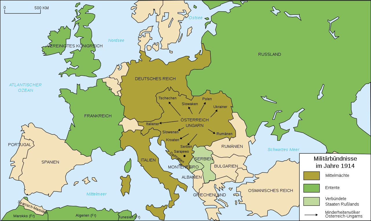
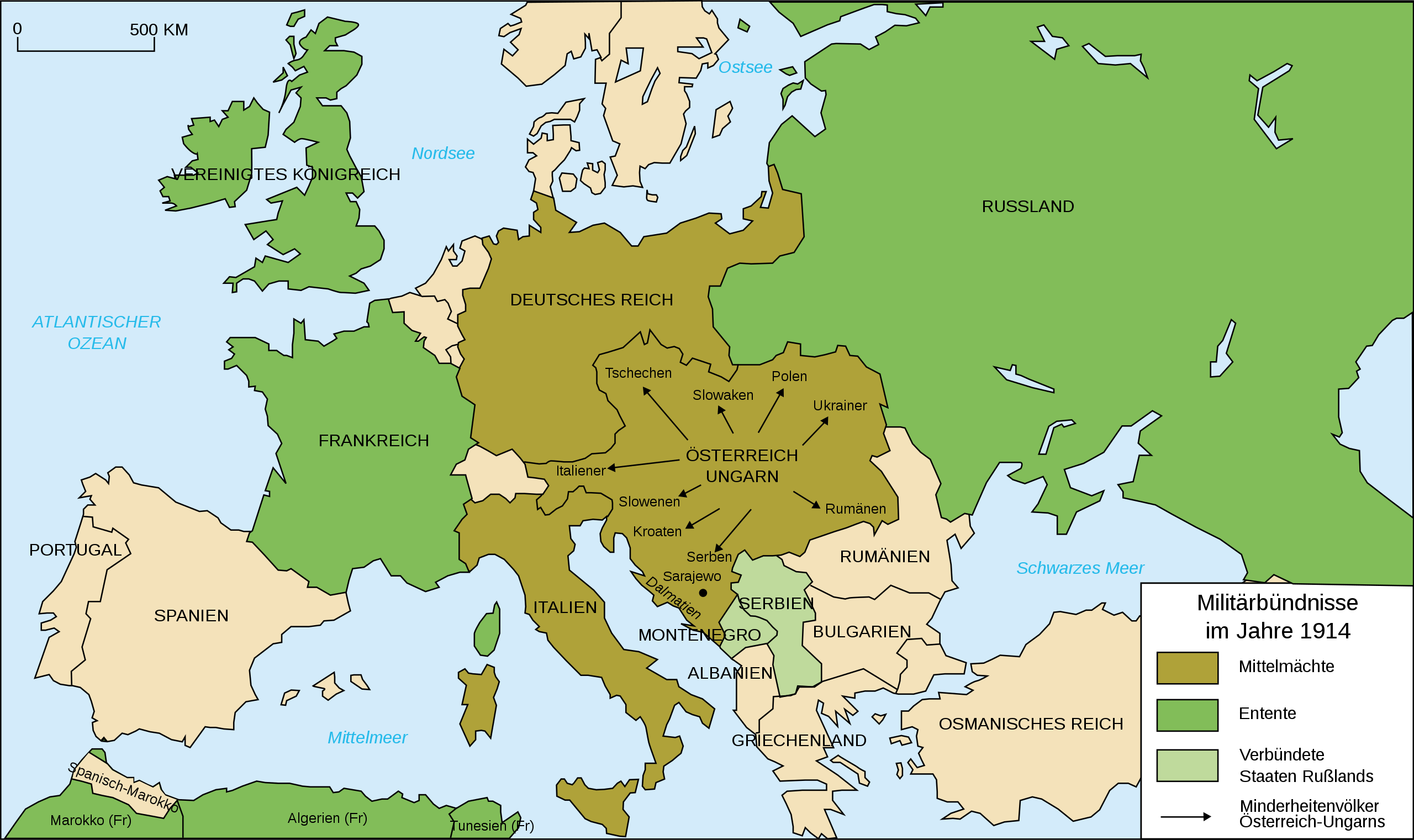
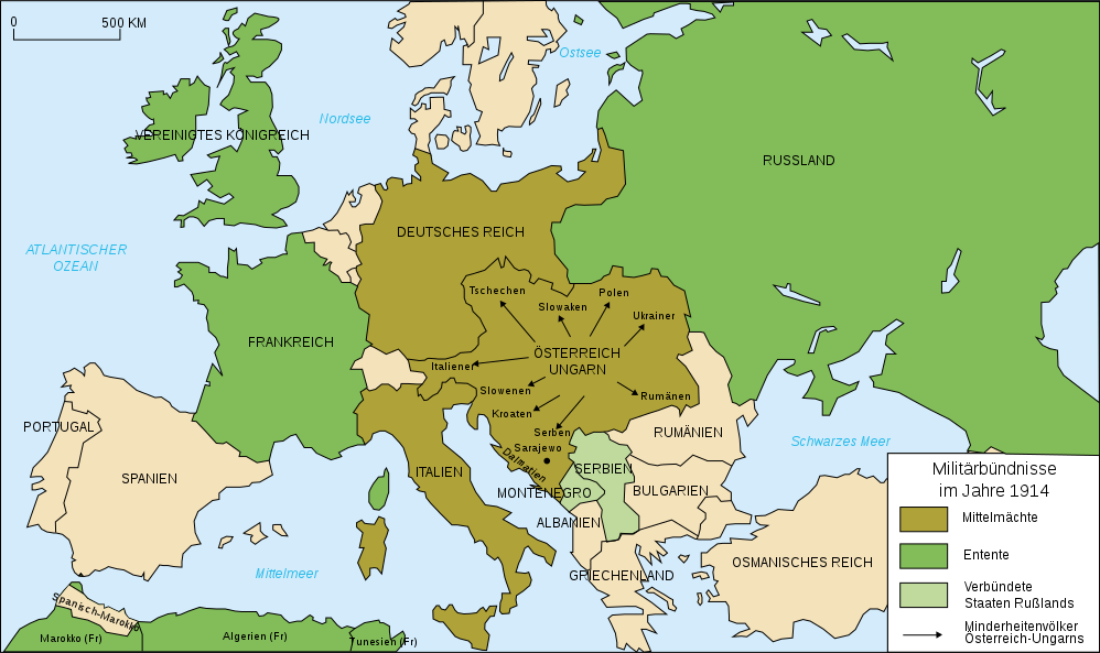
Deutsch: Karte von Militärbündnisse in Europa in 1914, (deutsch)
English: Map of military alliances of Europe in 1914. (German)
Français : Carte des alliances militaires en Europe en 1914 (Allemagne).
Русский: Схема военных альянсов в Европе в 1914 г. (нем.) |
| Datum | (UTC) |
| Bron | |
| Auteur |
|
| Andere versies |
Afgeleide werken van dit bestand: Map Europe alliances 1914-sv.svg
[] .gif)
|


| Dit is een geretoucheerde foto, wat betekent dat de originele versie digitaal aangepast is. Aanpassingen: Into German, auf deutsch. Het origineel kan hier bekeken worden: Map Europe alliances 1914-fr.svg. Aanpassingen gedaan door Danbornekde.
|
Ik, de auteursrechthebbende van dit werk, maak het hierbij onder de volgende licentie beschikbaar:
Dit bestand is gelicenseerd onder de Creative Commons-licenties Naamsvermelding-Gelijk delen 2.5 Algemeen, 2.0 Algemeen en 1.0 Algemeen.
- De gebruiker mag:
- Delen – het werk kopiëren, verspreiden en doorgeven
- Remixen – afgeleide werken maken
- Onder de volgende voorwaarden:
- naamsvermelding – U moet op een gepaste manier aan naamsvermelding doen, een link naar de licentie geven, en aangeven of er wijzigingen in het werk zijn aangebracht. U mag dit op elke redelijke manier doen, maar niet zodanig dat de indruk wordt gewekt dat de licentiegever instemt met uw werk of uw gebruik van zijn werk.
- Gelijk delen – Als u het werk heeft geremixt, veranderd, of erop heeft voortgebouwd, moet u het gewijzigde materiaal verspreiden onder dezelfde licentie als het oorspronkelijke werk, of een daarmee compatibele licentie.
Oorspronkelijk uploadlogboek
This image is a derivative work of the following images:
- Image:Map_Europe_alliances_1914-fr.svg licensed with Cc-by-sa-2.5,2.0,1.0
- 2007-02-26T23:36:35Z Bibi Saint-Pol 998x593 (100171 Bytes) {{Information |Description= {{fr|Carte des alliances militaires en Europe en 1914.}} |Source=Création personnelle (version renommée de [[:Image:Les rivalités en Europe en 1914.svg]]) |Date=2006-10-31 |Author=[[User:Histori
Uploaded with derivativeFX
Bestandsgeschiedenis
Klik op een datum/tijd om het bestand te zien zoals het destijds was.
| Datum/tijd | Miniatuur | Afmetingen | Gebruiker | Opmerking | |
|---|---|---|---|---|---|
| huidige versie | 1 feb 2020 22:34 | | 998 × 593 (124 kB) | Radek Linner | File uploaded using svgtranslate tool (https://tools.wmflabs.org/svgtranslate/). Added translation for cs. |
| 30 nov 2015 23:15 |  | 998 × 593 (98 kB) | Turnless | Russian islands | |
| 19 jul 2010 13:14 |  | 998 × 593 (98 kB) | KaterBegemot | Minor graphical corrections. "Militärbündnisse in 1914" was a incorrect translation. | |
| 26 jan 2009 00:25 |  | 998 × 593 (100 kB) | Tinloaf | Fixing some spelling mistakes. | |
| 4 okt 2008 04:00 |  | 998 × 593 (98 kB) | Danbornekde~commonswiki | {{Information |Description={{fr|Carte des alliances militaires en Europe en 1914.}} Karte von Militärbündnisse in Europa in 1914, deutsch |Source=*Image:Map_Europe_alliances_1914-fr.svg |Date=2008-10-04 01:57 (UTC) |Author=*derivative work: ~~~ * |
Bestandsgebruik
Geen enkele pagina gebruikt dit bestand.
Globaal bestandsgebruik
De volgende andere wiki's gebruiken dit bestand:
- Gebruikt op de.wikipedia.org
- Gebruikt op nds.wikipedia.org
- Gebruikt op rm.wikipedia.org
- Gebruikt op zh.wikipedia.org