
Bestand:Map boatlifts canal du centre.svg

Afmetingen van deze voorvertoning van het type PNG van dit SVG-bestand: 534 × 375 pixels Andere resoluties: 320 × 225 pixels | 640 × 449 pixels | 1.024 × 719 pixels | 1.280 × 899 pixels | 2.560 × 1.798 pixels.
Oorspronkelijk bestand (SVG-bestand, nominaal 534 × 375 pixels, bestandsgrootte: 418 kB)
| Dit is een bestand van Wikimedia Commons. Onderstaande beschrijving komt van de beschrijving van het bestand daar. |
Beschrijving
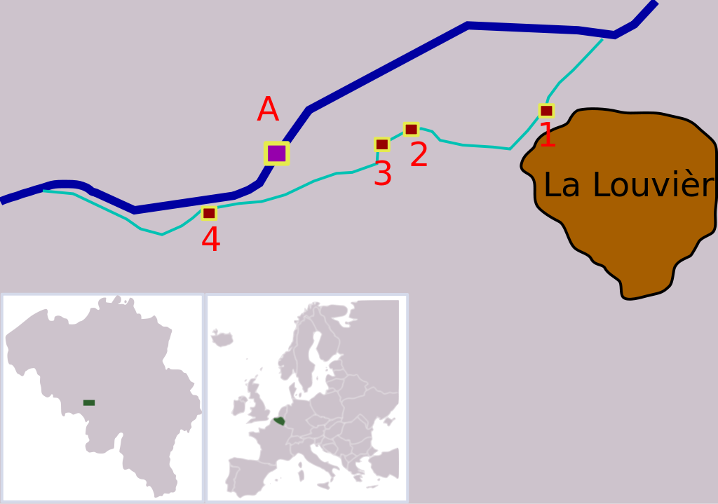
| Beschrijving | Map showing the locations of the four boatlifts on Canal du Centre, Belgium. The boatlifts are a UNESCO world heritage site. The numbers correspond with the UNESCO inscription, "A" is the new boatlift that replaced them. |
| Datum | |
| Bron |
Eigen werk Deze niet W3C-verklaarde vectorafbeelding is gemaakt met Inkscape . |
| Auteur | Finnrind |
Licentie
I, Finnrind, de auteursrechthebbende van dit werk, maakt het hierbij onder de volgende licenties beschikbaar:

|
Toestemming wordt verleend voor het kopiëren, verspreiden en/of wijzigen van dit document onder de voorwaarden van de GNU-licentie voor vrije documentatie, versie 1.2 of enige latere versie als gepubliceerd door de Free Software Foundation; zonder Invariant Sections, zonder Front-Cover Texts, en zonder Back-Cover Texts. Een kopie van de licentie is opgenomen in de sectie GNU-licentie voor vrije documentatie. |
| Dit bestand is gelicenseerd onder de Creative Commons-licentie Naamsvermelding-Gelijk delen 3.0 Unported | ||
| Naamsvermelding: I, Finnrind | ||
| ||
| Deze licentietag is toegevoegd aan dit bestand in verband met de GFDL licentie-update. |
Dit bestand is gelicenseerd onder de Creative Commons-licenties Naamsvermelding-Gelijk delen 2.5 Algemeen, 2.0 Algemeen en 1.0 Algemeen.
Naamsvermelding: I, Finnrind
- De gebruiker mag:
- Delen – het werk kopiëren, verspreiden en doorgeven
- Remixen – afgeleide werken maken
- Onder de volgende voorwaarden:
- naamsvermelding – U moet op een gepaste manier aan naamsvermelding doen, een link naar de licentie geven, en aangeven of er wijzigingen in het werk zijn aangebracht. U mag dit op elke redelijke manier doen, maar niet zodanig dat de indruk wordt gewekt dat de licentiegever instemt met uw werk of uw gebruik van zijn werk.
- Gelijk delen – Als u het werk heeft geremixt, veranderd, of erop heeft voortgebouwd, moet u het gewijzigde materiaal verspreiden onder dezelfde licentie als het oorspronkelijke werk, of een daarmee compatibele licentie.
U mag zelf één van de licenties kiezen.
Bestandsgeschiedenis
Klik op een datum/tijd om het bestand te zien zoals het destijds was.
| Datum/tijd | Miniatuur | Afmetingen | Gebruiker | Opmerking | |
|---|---|---|---|---|---|
| huidige versie | 15 jul 2007 21:08 | | 534 × 375 (418 kB) | Finnrind | |
| 15 jul 2007 20:31 |  | 534 × 375 (412 kB) | Finnrind | ||
| 15 jul 2007 20:25 |  | 534 × 375 (412 kB) | Finnrind | ||
| 15 jul 2007 20:21 |  | 258 × 183 (151 kB) | Finnrind | {{Information |Description=Map showing the locations of the four boatlifts on Canal du Centre, Belgium. The boatlifts are a UNESCO world heritage site. The numbers correspond with the UNESCO inscription, "A" is the new boatlift that replaced them. |Source |
Bestandsgebruik
Dit bestand wordt op de volgende 2 pagina's gebruikt:
Globaal bestandsgebruik
De volgende andere wiki's gebruiken dit bestand:
- Gebruikt op ca.wikipedia.org
- Gebruikt op de.wikipedia.org
- Gebruikt op en.wikipedia.org
- Gebruikt op eo.wikipedia.org
- Gebruikt op es.wikipedia.org
- Gebruikt op fi.wikipedia.org
- Gebruikt op fr.wikipedia.org
- Gebruikt op gl.wikipedia.org
- Gebruikt op he.wikipedia.org
- Gebruikt op hr.wikipedia.org
- Gebruikt op hu.wikipedia.org
- Gebruikt op lt.wikipedia.org
- Gebruikt op mt.wikipedia.org
- Gebruikt op no.wikipedia.org
- Gebruikt op pl.wikipedia.org
- Gebruikt op pt.wikipedia.org
- Gebruikt op ro.wikipedia.org
- Gebruikt op ru.wikipedia.org
- Gebruikt op sh.wikipedia.org
- Gebruikt op sr.wikipedia.org
- Gebruikt op zh.wikipedia.org