
Bestand:Map of Blair County Pennsylvania With Municipal and Township Labels.png
Geen hogere resolutie beschikbaar.
Map_of_Blair_County_Pennsylvania_With_Municipal_and_Township_Labels.png (420 × 516 pixels, bestandsgrootte: 36 kB, MIME-type: image/png)
| Dit is een bestand van Wikimedia Commons. Onderstaande beschrijving komt van de beschrijving van het bestand daar. |
Beschrijving
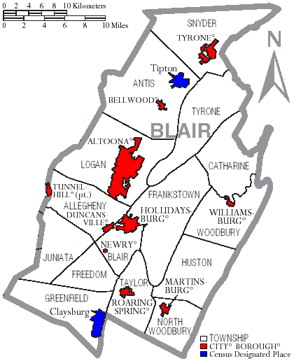
| Beschrijving | Map of Blair County, Pennsylvania, United States with township and municipal boundaries |
| Datum | |
| Bron | taken from US Census website [1] and modified by User:Ruhrfisch |
| Auteur | US Census, Ruhrfisch |
| Toestemming (Hergebruik van dit bestand) |
US Census / US Government work is public domain, my modifications licensed under the GNU Free Documentation License |
| Andere versies | one with error (had Tunnelhill) |
Licentie
I, Ruhrfisch, de auteursrechthebbende van dit werk, maakt het hierbij onder de volgende licenties beschikbaar:

|
Toestemming wordt verleend voor het kopiëren, verspreiden en/of wijzigen van dit document onder de voorwaarden van de GNU-licentie voor vrije documentatie, versie 1.2 of enige latere versie als gepubliceerd door de Free Software Foundation; zonder Invariant Sections, zonder Front-Cover Texts, en zonder Back-Cover Texts. Een kopie van de licentie is opgenomen in de sectie GNU-licentie voor vrije documentatie. |
| Dit bestand is gelicenseerd onder de Creative Commons-licentie Naamsvermelding-Gelijk delen 3.0 Unported | ||
| Naamsvermelding: I, Ruhrfisch | ||
| ||
| Deze licentietag is toegevoegd aan dit bestand in verband met de GFDL licentie-update. |
Dit bestand is gelicenseerd onder de Creative Commons-licentie Naamsvermelding-Gelijk delen 2.5 Unported
Naamsvermelding: I, Ruhrfisch
- De gebruiker mag:
- Delen – het werk kopiëren, verspreiden en doorgeven
- Remixen – afgeleide werken maken
- Onder de volgende voorwaarden:
- naamsvermelding – U moet op een gepaste manier aan naamsvermelding doen, een link naar de licentie geven, en aangeven of er wijzigingen in het werk zijn aangebracht. U mag dit op elke redelijke manier doen, maar niet zodanig dat de indruk wordt gewekt dat de licentiegever instemt met uw werk of uw gebruik van zijn werk.
- Gelijk delen – Als u het werk heeft geremixt, veranderd, of erop heeft voortgebouwd, moet u het gewijzigde materiaal verspreiden onder dezelfde licentie als het oorspronkelijke werk, of een daarmee compatibele licentie.
U mag zelf één van de licenties kiezen.
and
This image or file is a work of a United States Census Bureau employee, taken or made as part of that person's official duties. As a work of the U.S. federal government, the image is in the public domain.
|
 |
Bestandsgeschiedenis
Klik op een datum/tijd om het bestand te zien zoals het destijds was.
| Datum/tijd | Miniatuur | Afmetingen | Gebruiker | Opmerking | |
|---|---|---|---|---|---|
| huidige versie | 13 sep 2008 16:51 | | 420 × 516 (36 kB) | Ruhrfisch | Cleanup, all other information the same |
| 19 mei 2007 15:39 |  | 420 × 516 (36 kB) | Ruhrfisch | == Summary == {{Information| |Description= Map of Blair County, Pennsylvania, United States with township and municipal boundaries |Source= taken from US Census website [http://www2.census.gov/geo/maps/general_ref/cousub_outline/cen2k_pgsz/pa_cosub.pdf] | |
| 18 mei 2007 23:00 |  | 420 × 516 (36 kB) | Ruhrfisch | {{Information |Description=Map of Blair County Pennsylvania With Municipal and Township Labels.png |Source= taken from US Census website [http://www2.census.gov/geo/maps/general_ref/cousub_outline/cen2k_pgsz/pa_cosub.pdf] and modified by [[User:Ruhrfisch] | |
| 8 apr 2006 15:26 |  | 420 × 516 (38 kB) | Ruhrfisch | Map of Blair County, Pennsylvania, United States with township and municipal boundaries is taken from US Census website [http://www2.census.gov/geo/maps/general_ref/cousub_outline/cen2k_pgsz/pa_cosub.pdf] and modified by User:Ruhrfisch in April 2006. |
Bestandsgebruik
Dit bestand wordt op de volgende pagina gebruikt:
Globaal bestandsgebruik
De volgende andere wiki's gebruiken dit bestand:
- Gebruikt op de.wikipedia.org
- Gebruikt op en.wikipedia.org
- Gebruikt op es.wikipedia.org
- Gebruikt op ja.wikipedia.org
- Gebruikt op pl.wikipedia.org