
Bestand:Map of Columbia County Pennsylvania With Municipal and Township Labels.png
Geen hogere resolutie beschikbaar.
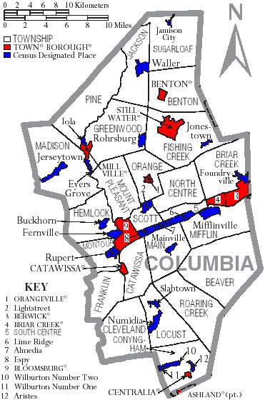
Map_of_Columbia_County_Pennsylvania_With_Municipal_and_Township_Labels.png (371 × 560 pixels, bestandsgrootte: 49 kB, MIME-type: image/png)
| Dit is een bestand van Wikimedia Commons. Onderstaande beschrijving komt van de beschrijving van het bestand daar. |
Beschrijving
Map of Columbia County, Pennsylvania, United States with township and municipal boundaries is taken from US Census website [1] and modified by User:Ruhrfisch in April 2006. My modifications licensed under the GNU Free Documentation License.
Source: US Census website [2]
Licentie

|
Toestemming wordt verleend voor het kopiëren, verspreiden en/of wijzigen van dit document onder de voorwaarden van de GNU-licentie voor vrije documentatie, versie 1.2 of enige latere versie als gepubliceerd door de Free Software Foundation; zonder Invariant Sections, zonder Front-Cover Texts, en zonder Back-Cover Texts. Een kopie van de licentie is opgenomen in de sectie GNU-licentie voor vrije documentatie. |
| Dit bestand is gelicenseerd onder de Creative Commons-licentie Naamsvermelding-Gelijk delen 3.0 Unported | ||
| ||
| Deze licentietag is toegevoegd aan dit bestand in verband met de GFDL licentie-update. |
Bestandsgeschiedenis
Klik op een datum/tijd om het bestand te zien zoals het destijds was.
| Datum/tijd | Miniatuur | Afmetingen | Gebruiker | Opmerking | |
|---|---|---|---|---|---|
| huidige versie | 13 sep 2008 17:06 | | 371 × 560 (49 kB) | Ruhrfisch | Cleanup, all other information the same |
| 11 apr 2006 17:50 |  | 371 × 560 (50 kB) | Ruhrfisch | Map of Columbia County, Pennsylvania, United States with township and municipal boundaries is taken from US Census website [http://www2.census.gov/geo/maps/general_ref/cousub_outline/cen2k_pgsz/pa_cosub.pdf] and modified by User:Ruhrfisch in April 200 | |
| 10 apr 2006 20:59 |  | 371 × 560 (50 kB) | Ruhrfisch | Map of Columbia County, Pennsylvania, United States with township and municipal boundaries is taken from US Census website [http://www2.census.gov/geo/maps/general_ref/cousub_outline/cen2k_pgsz/pa_cosub.pdf] and modified by User:Ruhrfisch in April 200 | |
| 10 apr 2006 03:57 |  | 371 × 560 (52 kB) | Ruhrfisch | Map of Columbia County, Pennsylvania, United States with township and municipal boundaries is taken from US Census website [http://www2.census.gov/geo/maps/general_ref/cousub_outline/cen2k_pgsz/pa_cosub.pdf] and modified by User:Ruhrfisch in April 200 |
Bestandsgebruik
Dit bestand wordt op de volgende pagina gebruikt:
Globaal bestandsgebruik
De volgende andere wiki's gebruiken dit bestand:
- Gebruikt op de.wikipedia.org
- Gebruikt op en.wikipedia.org
- Gebruikt op ja.wikipedia.org
- Gebruikt op pl.wikipedia.org
- Gebruikt op pt.wikipedia.org