
Bestand:Map of Tierra del Fuego showing Ona, Yahgan, Haush.jpg

Oorspronkelijk bestand (2.823 × 2.179 pixels, bestandsgrootte: 1,76 MB, MIME-type: image/jpeg)
| Dit is een bestand van Wikimedia Commons. Onderstaande beschrijving komt van de beschrijving van het bestand daar. |
Beschrijving
| Beschrijving |
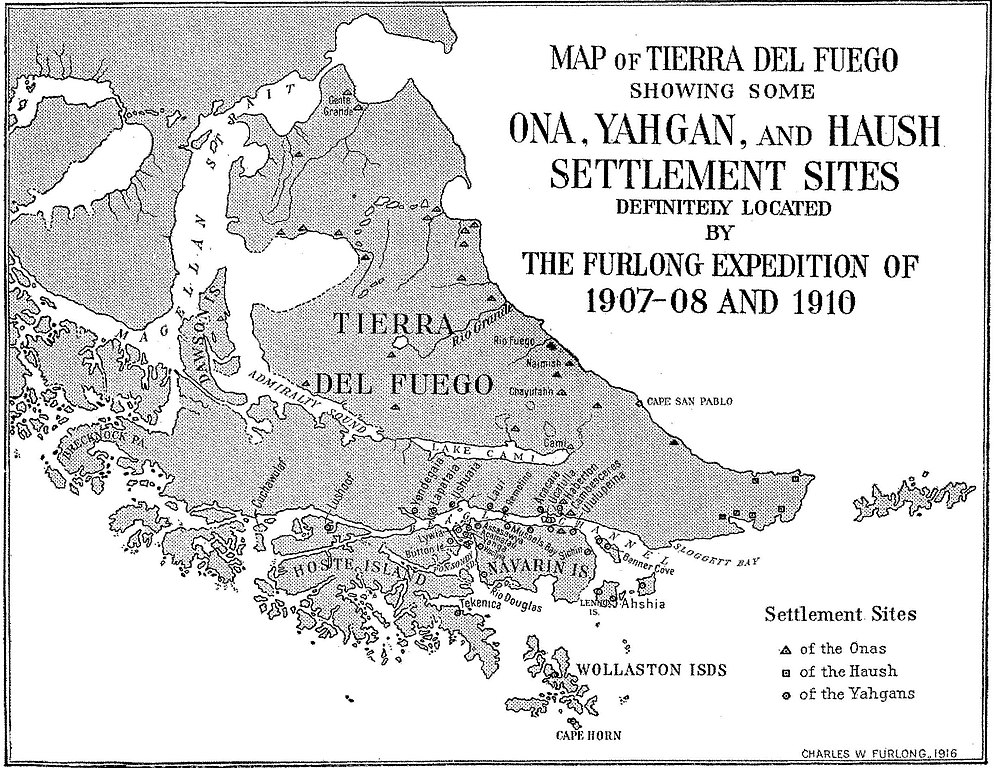
English: Fig. 4— Map of Tierra del Fuego showing some Ona, Yahgan, and Haush settlement sites. Scale,
1 :4,800,000. Note: The site at Cape San Pablo is an Ona site and should be represented by a triangle. Names have been given to these sites whenever possible. All are aboriginal names except the follow- ing: Gente Grande, Rio Fuego, Haberton, Cambesceres, Banner Cove, Rio Douglas, Mussels Bay, Button Island. The exact location of Lushoof is doubtful. Cuchawulaf is the name applied to the island and probably to its principal camp site. There are many other settlement sites not shown here. Some of those shown have been abandoned. With one or two exceptions these are or have been important settlements, supporting a fluctuating population, varying from a few families to perhaps over three hundred in case of the Yahgans, to perhaps one hundred in case of the Onas, but usually only small groups in the case of the Haush. Note the center of Yahgan population in Yahga and vicinity. |
| Datum | |
| Bron | Furlong, Charles Wellington. “Tribal Distribution and Settlements of the Fuegians, Comprising Nomenclature, Etymology, Philology, and Populations.” Geographical Review 3, no. 3 (1917): 169–87. https://doi.org/10.2307/207659; https://ia801605.us.archive.org/BookReader/BookReaderImages.php?zip=/12/items/jstor-207659/207659_jp2.zip&file=207659_jp2/207659_0009.jp2&scale=2.6745607333842627&rotate=0 |
| Auteur | Furlong, Charles Wellington |
Licentie
Dit mediabestand is in het publiek domein in de Verenigde Staten van Amerika. Dit geldt voor werken uit de VS waarvan de copyright is verlopen, meestal omdat de eerste publicatie ervan verscheen voor 1 januari 1929. Zie ook deze pagina voor verdere uitleg
|
 | |
 |
Let op! Dit bestand hoeft niet in het publiek domein te zijn buiten de VS (dit geldt voor Canada, China (excl. Hong Kong, Macao of Taiwan), Duitsland, Mexico en Zwitserland). De auteur en het jaar van publicatie zijn essentiële informatie en moeten zijn vastgesteld. Zie ook Wikipedia:Public domain en Wikipedia:Copyrights voor meer informatie.
|
Bestandsgeschiedenis
Klik op een datum/tijd om het bestand te zien zoals het destijds was.
| Datum/tijd | Miniatuur | Afmetingen | Gebruiker | Opmerking | |
|---|---|---|---|---|---|
| huidige versie | 13 jul 2016 20:44 | | 2.823 × 2.179 (1,76 MB) | Rec79 | {{Information |Description ={{en|1=Fig. 4— Map of Tierra del Fuego showing some Ona, Yahgan, and Haush settlement sites. Scale, 1 :4,800,000. Note: The site at Cape San Pablo is an Ona site and should be represented by a triangle. Names have be... |
Bestandsgebruik
Globaal bestandsgebruik
De volgende andere wiki's gebruiken dit bestand:
- Gebruikt op en.wikipedia.org
- Gebruikt op es.wikipedia.org
- Gebruikt op eu.wikipedia.org
- Gebruikt op ha.wikipedia.org
- Gebruikt op sv.wikipedia.org