
Bestand:Map of the Imperial Circles (1560)-en.svg

Afmetingen van deze voorvertoning van het type PNG van dit SVG-bestand: 613 × 600 pixels Andere resoluties: 245 × 240 pixels | 491 × 480 pixels | 785 × 768 pixels | 1.046 × 1.024 pixels | 2.093 × 2.048 pixels | 1.165 × 1.140 pixels.
Oorspronkelijk bestand (SVG-bestand, nominaal 1.165 × 1.140 pixels, bestandsgrootte: 336 kB)
| Dit is een bestand van Wikimedia Commons. Onderstaande beschrijving komt van de beschrijving van het bestand daar. |
Beschrijving
| Beschrijving |
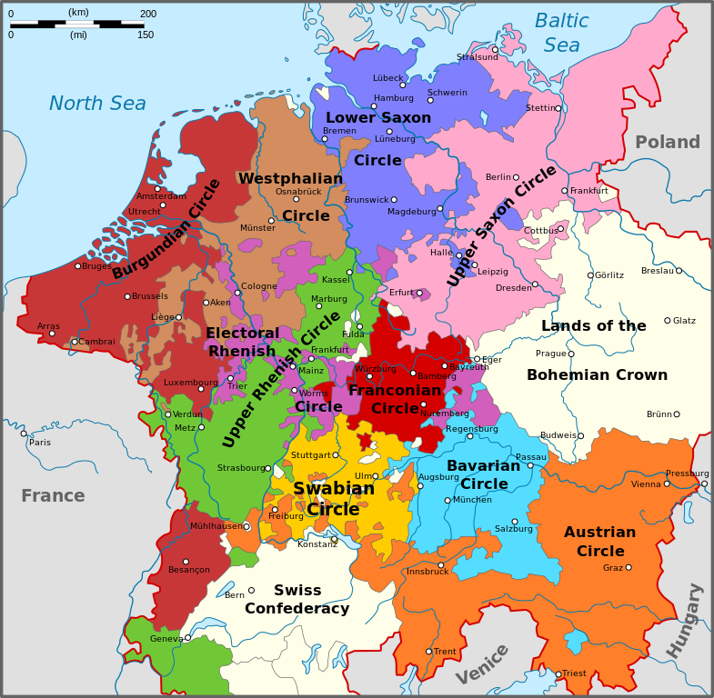
English: Map of the Imperial Circles after the Transaction of Augsburg (1548). English version.
Nederlands: Kaart van de Kreitsen na de Transactie van Augsburg (1548). Engelse versie.
Hrvatski: Karta okružja Svetog Rimskog Carstva nakon Augsburškog prijenosa iz 1548. Engleska inačica |
| Datum | |
| Bron | Eigen werk |
| Auteur | Sir Iain |
| Andere versies |
[] 1512
1560
|
-bg.png)
-de.png)
-en.png)
-fr.svg)
.png)
-de.svg)
-en.svg)
-es.svg)
-la.svg)
-nl.svg)
-en.svg)
Licentie
Ik, de auteursrechthebbende van dit werk, maak het hierbij onder de volgende licenties beschikbaar:
Dit bestand is gelicenseerd onder de Creative Commons-licentie Naamsvermelding-Gelijk delen 3.0 Unported
- De gebruiker mag:
- Delen – het werk kopiëren, verspreiden en doorgeven
- Remixen – afgeleide werken maken
- Onder de volgende voorwaarden:
- naamsvermelding – U moet op een gepaste manier aan naamsvermelding doen, een link naar de licentie geven, en aangeven of er wijzigingen in het werk zijn aangebracht. U mag dit op elke redelijke manier doen, maar niet zodanig dat de indruk wordt gewekt dat de licentiegever instemt met uw werk of uw gebruik van zijn werk.
- Gelijk delen – Als u het werk heeft geremixt, veranderd, of erop heeft voortgebouwd, moet u het gewijzigde materiaal verspreiden onder dezelfde licentie als het oorspronkelijke werk, of een daarmee compatibele licentie.

|
Toestemming wordt verleend voor het kopiëren, verspreiden en/of wijzigen van dit document onder de voorwaarden van de GNU-licentie voor vrije documentatie, versie 1.2 of enige latere versie als gepubliceerd door de Free Software Foundation; zonder Invariant Sections, zonder Front-Cover Texts, en zonder Back-Cover Texts. Een kopie van de licentie is opgenomen in de sectie GNU-licentie voor vrije documentatie. |
U mag zelf één van de licenties kiezen.
Bestandsgeschiedenis
Klik op een datum/tijd om het bestand te zien zoals het destijds was.
| Datum/tijd | Miniatuur | Afmetingen | Gebruiker | Opmerking | |
|---|---|---|---|---|---|
| huidige versie | 14 aug 2010 18:34 | | 1.165 × 1.140 (336 kB) | Sir Iain | The upper-Palatinate was actually part of the Electoral Rhenish Circle, contrary to almost all of the existing maps. |
| 29 jun 2010 12:42 |  | 1.165 × 1.140 (332 kB) | Sir Iain | Changed text on path to objects. Text on path wouldn't display correctly. | |
| 29 jun 2010 12:37 |  | 1.165 × 1.140 (279 kB) | Sir Iain | {{Information |Description={{en|1=Map of the Imperial Circles after the Transaction of Augsburg (1548). English version.}} {{nl|1=Kaart van de Kreitsen na de Transactie van Augsburg (1548). Engelse versie.}} |Source={{own}} |Author=[[User:Sir Iain|Sir Iai |
Bestandsgebruik
Geen enkele pagina gebruikt dit bestand.
Globaal bestandsgebruik
De volgende andere wiki's gebruiken dit bestand:
- Gebruikt op az.wikipedia.org
- Gebruikt op ca.wikipedia.org
- Gebruikt op cs.wikipedia.org
- Gebruikt op el.wikipedia.org
- Gebruikt op en.wikipedia.org
- Gebruikt op et.wikipedia.org
- Gebruikt op fi.wikipedia.org
- Gebruikt op hr.wikipedia.org
- Gebruikt op id.wikipedia.org
- Gebruikt op ja.wikipedia.org
- Gebruikt op ko.wikipedia.org
- Gebruikt op lt.wikipedia.org
- Senoji konfederacija
- Cešyno kunigaikštystė
- Nysos kunigaikštystė
- Racibužo kunigaikštystė
- Opolės kunigaikštystė
- Bžego kunigaikštystė
- Legnicos kunigaikštystė
- Gloguvo kunigaikštystė
- Parmos hercogystė
- Milano hercogystė
- Čekijos karalystė
- Monferato marka
- Frankonijos imperinė apygarda
- Austrijos imperinė apygarda
- Šablonas:Šventosios Romos imperijos teritorijos
- Burgundijos imperinė apygarda
- Žemutinio Reino-Vestfalijos imperinė apygarda
- Italijos karalystė (viduramžiai)
- Moravijos markgrafystė
- Gebruikt op lv.wikipedia.org
- Gebruikt op no.wikipedia.org
- Gebruikt op pt.wikipedia.org
- Gebruikt op sh.wikipedia.org
- Gebruikt op sr.wikipedia.org
- Gebruikt op tr.wikipedia.org
- Gebruikt op uk.wikipedia.org
Globaal gebruik van dit bestand bekijken.
-en.svg)
-en.svg)