
Bestand:Map of the provinces of South Africa 1910-1976 with English labels.svg

Afmetingen van deze voorvertoning van het type PNG van dit SVG-bestand: 684 × 599 pixels Andere resoluties: 274 × 240 pixels | 548 × 480 pixels | 876 × 768 pixels | 1.168 × 1.024 pixels | 2.337 × 2.048 pixels | 809 × 709 pixels.
Oorspronkelijk bestand (SVG-bestand, nominaal 809 × 709 pixels, bestandsgrootte: 393 kB)
| Dit is een bestand van Wikimedia Commons. Onderstaande beschrijving komt van de beschrijving van het bestand daar. |
Beschrijving
| Beschrijving |
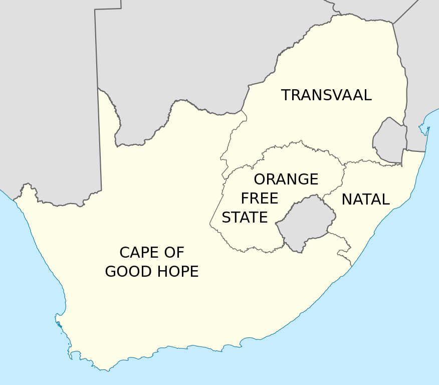
English: Map of South Africa showing the provinces as they were from 1910 to 1976, with labels in English. Based on File:Map of South Africa with provincial borders 1910-1976.svg. |
| Datum | |
| Bron | Eigen werk |
| Auteur | Htonl |
| Andere versies | File:Map of South Africa with provincial borders 1910-1976.svg, File:Kaart van die provinsies van Suid-Afrika 1910-1976 met Afrikaanse byskrifte.svg |
Licentie
Ik, de auteursrechthebbende van dit werk, maak het hierbij onder de volgende licenties beschikbaar:
Dit bestand is gelicenseerd onder de Creative Commons-licentie Naamsvermelding-Gelijk delen 3.0 Unported
- De gebruiker mag:
- Delen – het werk kopiëren, verspreiden en doorgeven
- Remixen – afgeleide werken maken
- Onder de volgende voorwaarden:
- naamsvermelding – U moet op een gepaste manier aan naamsvermelding doen, een link naar de licentie geven, en aangeven of er wijzigingen in het werk zijn aangebracht. U mag dit op elke redelijke manier doen, maar niet zodanig dat de indruk wordt gewekt dat de licentiegever instemt met uw werk of uw gebruik van zijn werk.
- Gelijk delen – Als u het werk heeft geremixt, veranderd, of erop heeft voortgebouwd, moet u het gewijzigde materiaal verspreiden onder dezelfde licentie als het oorspronkelijke werk, of een daarmee compatibele licentie.

|
Toestemming wordt verleend voor het kopiëren, verspreiden en/of wijzigen van dit document onder de voorwaarden van de GNU-licentie voor vrije documentatie, versie 1.2 of enige latere versie als gepubliceerd door de Free Software Foundation; zonder Invariant Sections, zonder Front-Cover Texts, en zonder Back-Cover Texts. Een kopie van de licentie is opgenomen in de sectie GNU-licentie voor vrije documentatie. |
U mag zelf één van de licenties kiezen.
Bestandsgeschiedenis
Klik op een datum/tijd om het bestand te zien zoals het destijds was.
| Datum/tijd | Miniatuur | Afmetingen | Gebruiker | Opmerking | |
|---|---|---|---|---|---|
| huidige versie | 7 mrt 2011 23:55 | | 809 × 709 (393 kB) | Htonl | == Summary == {{Information |Description ={{en|1=Map of South Africa showing the provinces as they were from 1910 to 1976, with labels in English. Based on File:Map of South Africa with provincial borders 1910-1976.svg.}} |Source ={{own}} |
Bestandsgebruik
Dit bestand wordt op de volgende pagina gebruikt:
Globaal bestandsgebruik
De volgende andere wiki's gebruiken dit bestand:
- Gebruikt op af.wikipedia.org
- Gebruikt op ar.wikipedia.org
- Gebruikt op ast.wikipedia.org
- Gebruikt op azb.wikipedia.org
- Gebruikt op bn.wikipedia.org
- Gebruikt op ca.wikipedia.org
- Gebruikt op de.wikipedia.org
- Gebruikt op en.wikipedia.org
- Gebruikt op es.wikipedia.org
- Gebruikt op id.wikipedia.org
- Gebruikt op it.wikipedia.org
- Gebruikt op ml.wikipedia.org
- Gebruikt op ms.wikipedia.org
- Gebruikt op pl.wikipedia.org
- Gebruikt op ro.wikipedia.org
- Gebruikt op sl.wikipedia.org
- Gebruikt op sw.wikipedia.org
- Gebruikt op th.wikipedia.org
- Gebruikt op tn.wikipedia.org
- Gebruikt op tr.wikipedia.org
- Gebruikt op uk.wikipedia.org
- Gebruikt op zh.wikipedia.org