
Bestand:Mentawai Islands Map.png

Grootte van deze voorvertoning: 521 × 600 pixels. Andere resoluties: 208 × 240 pixels | 417 × 480 pixels | 667 × 768 pixels | 889 × 1.024 pixels | 1.360 × 1.566 pixels.
Oorspronkelijk bestand (1.360 × 1.566 pixels, bestandsgrootte: 96 kB, MIME-type: image/png)
| Dit is een bestand van Wikimedia Commons. Onderstaande beschrijving komt van de beschrijving van het bestand daar. |
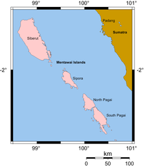
| Beschrijving | Map of the Mentawai Islands drawn by MichaelJLowe, based upon public domain map from [1]. |
| Datum | |
| Bron | self drawn |
| Auteur | MichaelJLowe |
| Toestemming (Hergebruik van dit bestand) |
Dit bestand is gelicenseerd onder de Creative Commons-licentie Naamsvermelding-Gelijk delen 2.5 Unported Naamsvermelding: Michael J. Lowe
|
Bestandsgeschiedenis
Klik op een datum/tijd om het bestand te zien zoals het destijds was.
| Datum/tijd | Miniatuur | Afmetingen | Gebruiker | Opmerking | |
|---|---|---|---|---|---|
| huidige versie | 13 apr 2007 13:42 | | 1.360 × 1.566 (96 kB) | MichaelJLowe | {{Information |Description=Map of the Mentawai Islands drawn by MichaelJLowe, based upon public domain map from [http://www.aquarius.geomar.de/omc]. |Source=self drawn |Date=2007-04 |Author=[[:en:User:Mic |
Bestandsgebruik
Dit bestand wordt op de volgende pagina gebruikt:
Globaal bestandsgebruik
De volgende andere wiki's gebruiken dit bestand:
- Gebruikt op ca.wikipedia.org
- Gebruikt op da.wikipedia.org
- Gebruikt op en.wikipedia.org
- Gebruikt op fr.wikipedia.org
- Gebruikt op he.wikipedia.org
- Gebruikt op ilo.wikipedia.org
- Gebruikt op it.wikipedia.org
- Gebruikt op lt.wikipedia.org
- Gebruikt op pl.wikipedia.org
- Gebruikt op pt.wikipedia.org
- Gebruikt op ru.wikipedia.org
- Gebruikt op vi.wikipedia.org