
Bestand:Moss Landing California aerial view.jpg

Grootte van deze voorvertoning: 800 × 534 pixels. Andere resoluties: 320 × 214 pixels | 640 × 427 pixels | 1.024 × 683 pixels | 1.500 × 1.001 pixels.
Oorspronkelijk bestand (1.500 × 1.001 pixels, bestandsgrootte: 644 kB, MIME-type: image/jpeg)
| Dit is een bestand van Wikimedia Commons. Onderstaande beschrijving komt van de beschrijving van het bestand daar. |
| Beschrijving |
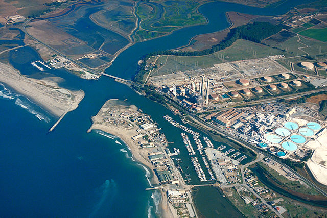
English: Aerial view of Moss Landing, Monterey County, California, USA. The Elkhorn slough runs the area and about 6 miles (8 km) inland. The huge Moss Landing Power Plant is visible at the center.
Coordinates: 36°48′21.95″N 121°46′57.55″W / 36.8060972°N 121.7826528°W |
|||
| Locatie | Moss Landing, Monterey County, California, USA | |||
| Datum | not specified or unknown | |||
| Bron |
U.S. Army Corps of Engineers Digital Visual Library Image page Image description page Digital Visual Library home page |
|||
| Auteur | U.S. Army Corps of Engineers, photographer not specified or unknown | |||
| Toestemming (Hergebruik van dit bestand) |
|
Bestandsgeschiedenis
Klik op een datum/tijd om het bestand te zien zoals het destijds was.
| Datum/tijd | Miniatuur | Afmetingen | Gebruiker | Opmerking | |
|---|---|---|---|---|---|
| huidige versie | 4 mei 2007 03:35 | | 1.500 × 1.001 (644 kB) | DanMS | {{Information | Description = {{en|Aerial view of Moss Landing, Monterey County, California, USA. The Elkhorn slough runs the area and about 6 miles (8 km) inland. The huge Moss Landing Power Plant is visible at the center. }} Coordinates: {{Coor dms| |
Bestandsgebruik
Dit bestand wordt op de volgende pagina gebruikt:
Globaal bestandsgebruik
De volgende andere wiki's gebruiken dit bestand:
- Gebruikt op azb.wikipedia.org
- Gebruikt op ceb.wikipedia.org
- Gebruikt op de.wikipedia.org
- Gebruikt op en.wikipedia.org
- Gebruikt op es.wikipedia.org
- Gebruikt op fa.wikipedia.org
- Gebruikt op fr.wikipedia.org
- Gebruikt op pt.wikipedia.org
- Gebruikt op sr.wikipedia.org
- Gebruikt op uk.wikipedia.org
- Gebruikt op vi.wikipedia.org
- Gebruikt op www.wikidata.org
- Gebruikt op zh.wikipedia.org