
Bestand:NorthAmerica-WaterDivides.png

Grootte van deze voorvertoning: 600 × 600 pixels. Andere resoluties: 240 × 240 pixels | 480 × 480 pixels | 900 × 900 pixels.
Oorspronkelijk bestand (900 × 900 pixels, bestandsgrootte: 370 kB, MIME-type: image/png)
| Dit is een bestand van Wikimedia Commons. Onderstaande beschrijving komt van de beschrijving van het bestand daar. |
Beschrijving
| Beschrijving |
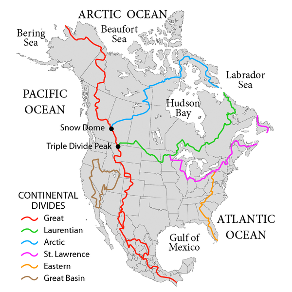
English: Map showing the major Continental divides of North America, following the style of File:NorthAmericaDivides.gif and intended as a replacement. Made using File:BlankMap-North America-Subdivisions.svg as a base map. Various maps and other sources consulted, such as: File:Ocean drainage.png, Drainage Basins, The Atlas of Canada, http://www.cec.org/atlas/files/watersheds/na_watersheds_en.jpg, and others. Note: the Eastern watershed boundary in the southern areas (orange line), and the St. Lawrence watershed boundary in the northern areas (magenta line) of this map more or less defined the Royal Proclamation's western boundaries. |
| Datum | |
| Bron | Eigen werk |
| Auteur | Pfly |
Licentie
Ik, de auteursrechthebbende van dit werk, maak het hierbij onder de volgende licenties beschikbaar:
Dit bestand is gelicenseerd onder de Creative Commons-licentie Naamsvermelding-Gelijk delen 3.0 Unported
- De gebruiker mag:
- Delen – het werk kopiëren, verspreiden en doorgeven
- Remixen – afgeleide werken maken
- Onder de volgende voorwaarden:
- naamsvermelding – U moet op een gepaste manier aan naamsvermelding doen, een link naar de licentie geven, en aangeven of er wijzigingen in het werk zijn aangebracht. U mag dit op elke redelijke manier doen, maar niet zodanig dat de indruk wordt gewekt dat de licentiegever instemt met uw werk of uw gebruik van zijn werk.
- Gelijk delen – Als u het werk heeft geremixt, veranderd, of erop heeft voortgebouwd, moet u het gewijzigde materiaal verspreiden onder dezelfde licentie als het oorspronkelijke werk, of een daarmee compatibele licentie.

|
Toestemming wordt verleend voor het kopiëren, verspreiden en/of wijzigen van dit document onder de voorwaarden van de GNU-licentie voor vrije documentatie, versie 1.2 of enige latere versie als gepubliceerd door de Free Software Foundation; zonder Invariant Sections, zonder Front-Cover Texts, en zonder Back-Cover Texts. Een kopie van de licentie is opgenomen in de sectie GNU-licentie voor vrije documentatie. |
U mag zelf één van de licenties kiezen.
Bestandsgeschiedenis
Klik op een datum/tijd om het bestand te zien zoals het destijds was.
| Datum/tijd | Miniatuur | Afmetingen | Gebruiker | Opmerking | |
|---|---|---|---|---|---|
| huidige versie | 1 okt 2019 04:47 | | 900 × 900 (370 kB) | Palaeozoic99 | Correct St. Lawrence |
| 22 nov 2018 09:12 |  | 900 × 900 (440 kB) | Pfly | Try to remove transparency one more time, sigh | |
| 22 nov 2018 08:51 |  | 900 × 900 (290 kB) | Pfly | Reverting to original with non-transparent background, as the transparency was displaying very badly, even unreadably, on mobile devices | |
| 22 nov 2018 08:49 |  | 900 × 900 (256 kB) | Pfly | revert my own reversion--made mistake | |
| 22 nov 2018 08:44 |  | 900 × 900 (290 kB) | Pfly | Reverted to version as of 21:09, 23 November 2010 (UTC): Transparent background looks very bad, even unreadable on mobile. | |
| 15 jul 2012 04:46 |  | 900 × 900 (256 kB) | Ubiquinoid | mildly updated: including names of oceans/seas in vicinity of North America (as displayed), per IHO | |
| 15 jul 2012 04:43 |  | 900 × 900 (256 kB) | Ubiquinoid | mildly updated: including names of oceans/seas in vicinity of North America (as displayed), per IHO | |
| 23 nov 2010 23:09 |  | 900 × 900 (290 kB) | Pfly | {{Information |Description={{en|1=Map showing the major Continental divides of North America, following the style of File:NorthAmericaDivides.gif and intended as a replacement. Made using [[:File:BlankMap-North America-Subd |
Bestandsgebruik
Dit bestand wordt op de volgende pagina gebruikt:
Globaal bestandsgebruik
De volgende andere wiki's gebruiken dit bestand:
- Gebruikt op ar.wikipedia.org
- Gebruikt op cs.wikipedia.org
- Gebruikt op de.wikipedia.org
- Gebruikt op en.wikipedia.org
- North America
- List of rivers of the Americas
- Royal Proclamation of 1763
- Continental Divide of the Americas
- Rupert's Land
- Pigeon River (Minnesota–Ontario)
- Atlantic seaboard watershed
- Eastern Continental Divide
- Talk:Kensington Runestone
- Talk:List of lighthouses in the United States
- Great Divide Basin
- Central United States
- Triple Divide Peak (Montana)
- Chicago Portage
- Snow Dome (Canada)
- Hudson Bay drainage basin
- Geography of North America
- Laurentian Divide
- Continental divide
- Great Basin Divide
- Watersheds of North America
- Canadian canoe routes
- Voyageurs
- Pacific Slope
- Centennial Voyageur Canoe Pageant
- Triple divide
- St. Lawrence River Divide
- Timeline of Alberta history
- Gebruikt op en.wiktionary.org
- Gebruikt op eo.wikipedia.org
- Gebruikt op es.wikipedia.org
- Gebruikt op fr.wikipedia.org
- Gebruikt op hr.wikipedia.org
- Gebruikt op id.wikipedia.org
- Gebruikt op ig.wikipedia.org
- Gebruikt op it.wikipedia.org
Globaal gebruik van dit bestand bekijken.