
Bestand:October 2012 - Overall Excellence in Smart Growth 2012- Lancaster, CA, The BLVD Transformation (8634270433).jpg

Oorspronkelijk bestand (5.616 × 3.744 pixels, bestandsgrootte: 12,78 MB, MIME-type: image/jpeg)
| Dit is een bestand van Wikimedia Commons. Onderstaande beschrijving komt van de beschrijving van het bestand daar. |
.jpg)
Beschrijving
| Beschrijving |
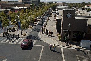
The redesign of Lancaster Boulevard helped transform downtown Lancaster into a thriving residential and commercial district through investments in new streetscape design, public facilities, affordable homes, and local businesses. Dubbed “The BLVD Transformation,” this comprehensive effort engaged residents and businesses to revitalize the formerly dilapidated downtown and make it a distinctive destination. Completed after just eight months of construction, The BLVD demonstrates how redesigning a corridor guided by a strategic vision can spark new life in a community. Photo courtesy of EPA. www.epa.gov/smartgrowth/awards/sg_awards_publication_2012... |
| Datum | |
| Bron | October 2012 - Overall Excellence in Smart Growth 2012: Lancaster, CA, The BLVD Transformation |
| Auteur | USEPA Environmental-Protection-Agency |
| Cameralocatie | | Deze en andere afbeeldingen in: OpenStreetMap |
|---|
.jpg¶ms=034.697907_N_-118.142037_E_globe:Earth_type:camera_source:Flickr_&language=nl)
Licentie
Deze afbeelding of andere media is een werk van een werknemer van de Environmental Protection Agency, gemaakt tijdens de officiële taken van een werknemer. Als werk van de Amerikaanse federale overheid, bevinden zich alle EPA-bestanden zich in het publiek domein.
|
||
| Deze afbeelding is oorspronkelijk op Flickr geplaatst door usepagov op https://flickr.com/photos/24400159@N05/8634270433. Dit is op 1 oktober 2016 door de FlickreviewR-Bot beoordeeld en de licentie onder de voorwaarden van United States Government Work is bevestigd. |
Bestandsgeschiedenis
Klik op een datum/tijd om het bestand te zien zoals het destijds was.
| Datum/tijd | Miniatuur | Afmetingen | Gebruiker | Opmerking | |
|---|---|---|---|---|---|
| huidige versie | 1 okt 2016 07:50 | | 5.616 × 3.744 (12,78 MB) | Vanished Account Byeznhpyxeuztibuo | Transferred from Flickr via Flickr2Commons |
Bestandsgebruik
Dit bestand wordt op de volgende pagina gebruikt:
Globaal bestandsgebruik
De volgende andere wiki's gebruiken dit bestand:
- Gebruikt op ar.wikipedia.org
- Gebruikt op arz.wikipedia.org
- Gebruikt op azb.wikipedia.org
- Gebruikt op be.wikipedia.org
- Gebruikt op bg.wikipedia.org
- Gebruikt op ca.wikipedia.org
- Gebruikt op ce.wikipedia.org
- Gebruikt op dag.wikipedia.org
- Gebruikt op de.wikipedia.org
- Gebruikt op en.wikipedia.org
- Gebruikt op en.wikivoyage.org
- Gebruikt op eo.wikipedia.org
- Gebruikt op es.wikipedia.org
- Gebruikt op eu.wikipedia.org
- Gebruikt op fr.wikipedia.org
- Gebruikt op ga.wikipedia.org
- Gebruikt op he.wikivoyage.org
- Gebruikt op ht.wikipedia.org
- Gebruikt op hu.wikipedia.org
- Gebruikt op it.wikipedia.org
- Gebruikt op it.wikivoyage.org
- Gebruikt op ko.wikipedia.org
- Gebruikt op lld.wikipedia.org
- Gebruikt op no.wikipedia.org
- Gebruikt op pt.wikipedia.org
- Gebruikt op ro.wikipedia.org
- Gebruikt op ru.wikipedia.org
- Gebruikt op sr.wikipedia.org
- Gebruikt op sw.wikipedia.org
- Gebruikt op szl.wikipedia.org
- Gebruikt op tt.wikipedia.org
- Gebruikt op uk.wikipedia.org
- Gebruikt op uz.wikipedia.org
- Gebruikt op vo.wikipedia.org
- Gebruikt op www.wikidata.org
- Gebruikt op zh.wikipedia.org
.jpg)