
Bestand:Overland-Richmond.png
Grootte van deze voorvertoning: 392 × 599 pixels. Andere resoluties: 157 × 240 pixels | 314 × 480 pixels | 502 × 768 pixels | 670 × 1.024 pixels | 1.594 × 2.436 pixels.
Oorspronkelijk bestand (1.594 × 2.436 pixels, bestandsgrootte: 769 kB, MIME-type: image/png)
| Dit is een bestand van Wikimedia Commons. Onderstaande beschrijving komt van de beschrijving van het bestand daar. |
Beschrijving
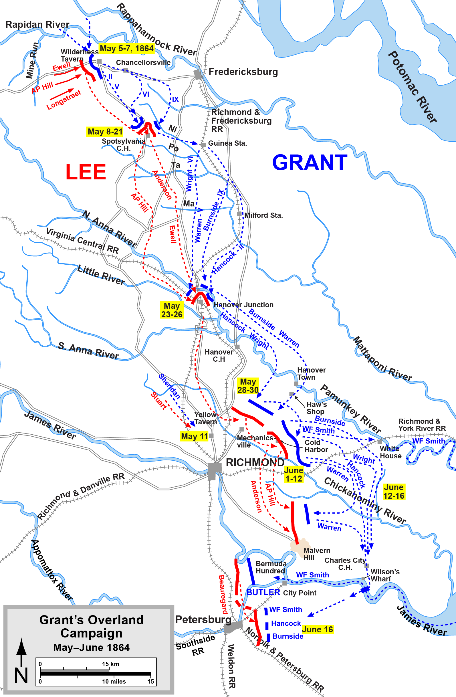
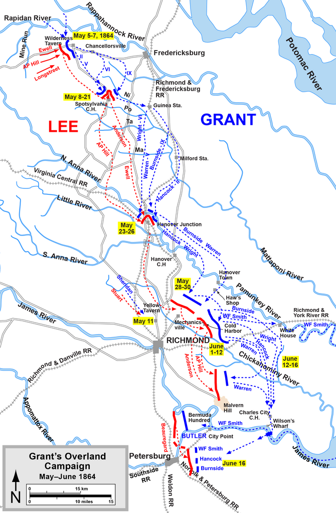
| Beschrijving | Overland Campaign |
| Bron | Graphic source file is available at http://www.posix.com/CWmaps/ |
| Auteur | Drawn by Hal Jespersen in Adobe Illustrator CS5. |
Licentie
Dit bestand is gelicenseerd onder de Creative Commons-licentie Naamsvermelding 3.0 Unported
Naamsvermelding: Map by Hal Jespersen, www.posix.com/CW
- De gebruiker mag:
- Delen – het werk kopiëren, verspreiden en doorgeven
- Remixen – afgeleide werken maken
- Onder de volgende voorwaarden:
- naamsvermelding – U moet op een gepaste manier aan naamsvermelding doen, een link naar de licentie geven, en aangeven of er wijzigingen in het werk zijn aangebracht. U mag dit op elke redelijke manier doen, maar niet zodanig dat de indruk wordt gewekt dat de licentiegever instemt met uw werk of uw gebruik van zijn werk.
Bestandsgeschiedenis
Klik op een datum/tijd om het bestand te zien zoals het destijds was.
| Datum/tijd | Miniatuur | Afmetingen | Gebruiker | Opmerking | |
|---|---|---|---|---|---|
| huidige versie | 17 apr 2011 00:12 | | 1.594 × 2.436 (769 kB) | Hlj | Add a label for Wilson's Wharf. Same license. |
| 6 apr 2011 23:45 |  | 1.594 × 2.436 (766 kB) | Hlj | Added some more detail to the road network (needed for a related map). Same license. | |
| 17 mrt 2011 22:01 |  | 1.594 × 2.436 (739 kB) | Hlj | Minor graphical changes to conform to new ACW map style for roads and rivers. Same license. | |
| 4 aug 2010 22:57 |  | 1.607 × 2.436 (667 kB) | Hlj | New version improves accuracy of unit positions and graphic style that matches others in the ACW series. Added legend box. Drawn by Hal Jespersen in Adobe Illustrator CS5. Graphic source file is available at http://www.posix.com/CWmaps/ {{cc-by-3.0|Map by | |
| 16 nov 2007 18:00 |  | 757 × 1.165 (716 kB) | Hlj | {{Information |Description=Map of 1864 Overland Campaign |Source=self-made |Date=corrected typo November 16, 2007 |Author= Hlj |Permission= |other_versions= }} | |
| 27 aug 2006 09:33 |  | 1.504 × 2.325 (874 kB) | Edmund Ferman |
Bestandsgebruik
Dit bestand wordt op de volgende 2 pagina's gebruikt:
Globaal bestandsgebruik
De volgende andere wiki's gebruiken dit bestand:
- Gebruikt op da.wikipedia.org
- Gebruikt op de.wikipedia.org
- Gebruikt op es.wikipedia.org
- Gebruikt op fi.wikipedia.org
- Gebruikt op fr.wikipedia.org
- Gebruikt op hu.wikipedia.org
- Gebruikt op it.wikipedia.org
- Gebruikt op ja.wikipedia.org
- Gebruikt op la.wikipedia.org
- Gebruikt op no.wikipedia.org
- Gebruikt op pt.wikipedia.org
- Gebruikt op ru.wikipedia.org
- Gebruikt op vi.wikipedia.org