
Bestand:Pakistan-Waziristan-Map.png

Grootte van deze voorvertoning: 606 × 599 pixels. Andere resoluties: 243 × 240 pixels | 486 × 480 pixels | 700 × 692 pixels.
Oorspronkelijk bestand (700 × 692 pixels, bestandsgrootte: 96 kB, MIME-type: image/png)
| Dit is een bestand van Wikimedia Commons. Onderstaande beschrijving komt van de beschrijving van het bestand daar. |
Beschrijving
| Beschrijving |
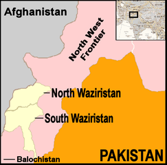
English: Map showing location of North and South Waziristan in northern Pakistan and bordering on Afghanistan |
||||
| Datum | |||||
| Bron | drawn by uploader using Jasc Paint Shop, using as insert map a reference map in Public Domain from the United States Central Intelligence Agency | ||||
| Auteur | Thaddeus P. Bejnar | ||||
| Toestemming (Hergebruik van dit bestand) |
Public Domain, I (Thaddeus P. Bejnar) hereby release this work to the Public Domain | ||||
| Andere versies |
|


.svg)

.png)


.svg)


.svg)


_Territory_Change_2014-2016.gif)

_(within_Northern_Syria).svg)


.png)
.svg)


_map.png)
.svg)


.svg)


Licentie
| Ik, de auteursrechthebbende van dit werk, geef dit werk vrij in het publieke domein. Dit is wereldwijd van toepassing. In sommige landen is dit wettelijk niet mogelijk; in die gevallen geldt: Ik sta iedereen toe dit werk voor eender welk doel te gebruiken, zonder enige voorwaarden, tenzij zulke voorwaarden door de wet worden voorgeschreven. |
Bestandsgeschiedenis
Klik op een datum/tijd om het bestand te zien zoals het destijds was.
| Datum/tijd | Miniatuur | Afmetingen | Gebruiker | Opmerking | |
|---|---|---|---|---|---|
| huidige versie | 7 nov 2006 23:59 | | 700 × 692 (96 kB) | Bejnar | {{Information |Description=Map showing location of North and South Waziristan in northern Pakistan and bordering on Afghanistan |Source=drawn by uploader using Jasc Paint Shop |Date=7 November 2006 |Author=Thaddeus P. Bejnar |Permission=Public Domain, I ( |
Bestandsgebruik
Dit bestand wordt op de volgende 2 pagina's gebruikt:
Globaal bestandsgebruik
De volgende andere wiki's gebruiken dit bestand:
- Gebruikt op ar.wikipedia.org
- Gebruikt op ca.wikipedia.org
- Gebruikt op cs.wikipedia.org
- Gebruikt op cy.wikipedia.org
- Gebruikt op de.wikinews.org
- Gebruikt op en.wikinews.org
- 17 troops killed in bombing on Afghanistan-Pakistan border; Separate bombing kills dozens of civilians
- High level al-Qaeda leader reported dead
- Pakistani military launches ground offensive against Taliban and al-Qaeda
- Pakistan: Twelve militants killed in recent fighting
- Suspected US drone attack kills at least fourteen in Pakistan
- Gebruikt op fr.wikipedia.org
- Gebruikt op it.wikipedia.org
- Gebruikt op pt.wikipedia.org
- Gebruikt op pt.wikinews.org