
Bestand:Papilio glaucus range map.JPG

Grootte van deze voorvertoning: 519 × 599 pixels. Andere resoluties: 208 × 240 pixels | 524 × 605 pixels.
Oorspronkelijk bestand (524 × 605 pixels, bestandsgrootte: 51 kB, MIME-type: image/jpeg)
| Dit is een bestand van Wikimedia Commons. Onderstaande beschrijving komt van de beschrijving van het bestand daar. |
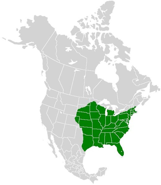
| Beschrijving | A range map showing the distribution of the Eastern Tiger Swallowtail (Papilio glaucus) |
| Datum | (UTC) |
| Bron | |
| Auteur |
|
| Dit is een geretoucheerde foto, wat betekent dat de originele versie digitaal aangepast is. Aanpassingen: I added color to show the range of the Eastern Tiger Swallowtail. Het origineel kan hier bekeken worden: North America second level political division 2.svg. Aanpassingen gedaan door Meganmccarty.
|
Ik, de auteursrechthebbende van dit werk, maak het hierbij onder de volgende licentie beschikbaar:
Dit bestand is gelicenseerd onder de Creative Commons-licentie Naamsvermelding-Gelijk delen 2.5 Unported
- De gebruiker mag:
- Delen – het werk kopiëren, verspreiden en doorgeven
- Remixen – afgeleide werken maken
- Onder de volgende voorwaarden:
- naamsvermelding – U moet op een gepaste manier aan naamsvermelding doen, een link naar de licentie geven, en aangeven of er wijzigingen in het werk zijn aangebracht. U mag dit op elke redelijke manier doen, maar niet zodanig dat de indruk wordt gewekt dat de licentiegever instemt met uw werk of uw gebruik van zijn werk.
- Gelijk delen – Als u het werk heeft geremixt, veranderd, of erop heeft voortgebouwd, moet u het gewijzigde materiaal verspreiden onder dezelfde licentie als het oorspronkelijke werk, of een daarmee compatibele licentie.
Oorspronkelijk uploadlogboek
This image is a derivative work of the following images:
- File:North_America_second_level_political_division_2.svg licensed with Cc-by-sa-2.5, Cc-by-sa-2.5
- 2007-12-08T23:23:36Z Lokal Profil 1712x1992 (335351 Bytes) Code cleanup
- 2007-10-07T07:55:13Z AlexCovarrubias 1712x1992 (350437 Bytes) == Summary == {{Information |Description=Map of North America and its second-level political divisions. Canadian provinces, US and Mexican states. Canada, Mexico, United States. |Source=Canada and US map by Alan Rockefeller.
Uploaded with derivativeFX
Bestandsgeschiedenis
Klik op een datum/tijd om het bestand te zien zoals het destijds was.
| Datum/tijd | Miniatuur | Afmetingen | Gebruiker | Opmerking | |
|---|---|---|---|---|---|
| huidige versie | 21 jan 2011 00:11 | | 524 × 605 (51 kB) | Meganmccarty | Removed range from Mexico and southern tip of Florida. Papilio glaucus is not found in these areas. P. alexiares replaces P. glaucus in Mexico. |
| 31 dec 2008 20:41 |  | 531 × 613 (26 kB) | Meganmccarty | {{Information |Description={{en|Map of North America and its second-level political divisions. Canadian provinces, US and Mexican states. Canada, Mexico, United States. Non-contiguous parts of a states/provinces are "grouped" together with the main area |
Bestandsgebruik
Dit bestand wordt op de volgende pagina gebruikt:
Globaal bestandsgebruik
De volgende andere wiki's gebruiken dit bestand:
- Gebruikt op arz.wikipedia.org
- Gebruikt op bg.wikipedia.org
- Gebruikt op ceb.wikipedia.org
- Gebruikt op cy.wikipedia.org
- Gebruikt op de.wikipedia.org
- Gebruikt op en.wikipedia.org
- Gebruikt op fr.wikipedia.org
- Gebruikt op gd.wiktionary.org
- Gebruikt op it.wikipedia.org
- Gebruikt op ml.wikipedia.org
- Gebruikt op ru.wikipedia.org
- Gebruikt op sv.wikipedia.org
- Gebruikt op vi.wikipedia.org
- Gebruikt op war.wikipedia.org
- Gebruikt op www.wikidata.org
- Gebruikt op zh.wikipedia.org