
Bestand:Provinces of France.png
Grootte van deze voorvertoning: 596 × 599 pixels. Andere resoluties: 239 × 240 pixels | 477 × 480 pixels | 894 × 899 pixels.
Oorspronkelijk bestand (894 × 899 pixels, bestandsgrootte: 39 kB, MIME-type: image/png)
| Dit is een bestand van Wikimedia Commons. Onderstaande beschrijving komt van de beschrijving van het bestand daar. |

|
Bestand:Provinces of France (numered-monochrome).svg is een vectorversie van dit bestand. Indien niet van slechtere kwaliteit dient deze gebruikt te worden in plaats van deze rasterafbeelding.
File:Provinces of France.png → File:Provinces of France (numered-monochrome).svg
Zie Help:SVG voor meer informatie. |
.svg) |
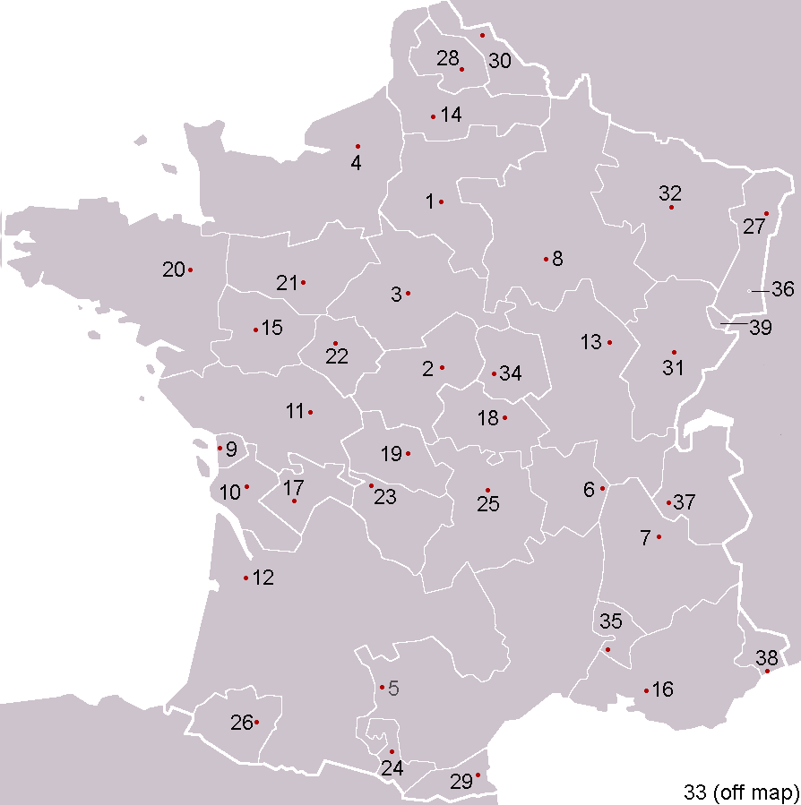
Beschrijving
Español: Provincias de Francia
Pre-Republican provinces of France, numbered according to union with France, with provincial capitals marked.
Created by reference to a 1952 Nouveau Petit Larousse by User:OwenBlacker and licenced under the GFDL.
Provinces as follows, in the format English name (French name, Year of union; Capital):
- Royal Domain (Île-de-France, 987, Paris)
- Berry (Berry, 1101, Bourges)
- Duchy of Orléanais (Orléanais, 1198, Orléans)
- Normandy (Normandie, 1204, Rouen)
- Languedoc, mainly the County of Toulouse (Languedoc, 1270, Toulouse)
- Lyonnais (Lyonnais, 1313, Lyon)
- Dauphiné, (Dauphiné, 1349, Grenoble)
- County of Champagne (Champagne, 1361, Troyes)
- Aunis, a fief of Aquitaine (Aunis, 1371, La Rochelle)
- Saintonge (Saintonge, 1371, Saintes)
- Poitou (Poitou, 1416, Poitiers)
- Duchy of Aquitaine (Aquitaine, 1453, Bordeaux), taken from England and split into provinces of Gascogne (Armagnac) and Guyenne (Bordeaux), but excluding the viscounties of Foix, Béarn, Bigorre and Périgord (kept by Navarre)
- Duchy of Burgundy (Bourgogne, 1477, Dijon)
- Picardy (Picardie, 1482, Amiens)
- Anjou (Anjou, 1482, Angers)
- County of Provence (Provence, 1482, Aix-en-Provence)
- County of Angoulême (Angoumois, 1515, Angoulême)
- Duchy of Bourbon (Bourbonnais, 1527, Moulins)
- La Marche (Marche, 1527, Guéret)
- Duchy of Britanny (Bretagne, 1532, Rennes)
- County of Maine (Maine, 1584, Le Mans) and County of Perche (Perche, 1525, Nogent-le-Rotrou)
- Touraine (Touraine, 1584, Tours)
- Limousin (Limousin, 1589, Limoges), excluding Viscounty of Périgord (kept by Navarre)
- County of Foix (Comté de Foix, 1607, Foix) and Viscounty of Périgord (Périgord, 1607, Périgueux, attached to province of Guyenne), both former fiefs from Navarre
- Duchy of Auvergne (Auvergne, 1610, Clermont-Ferrand)
- Viscounty of Béarn (Béarn, 1620, Pau)
- Alsace (Alsace, 1648, Strasbourg)
- County of Artois, a fief of the w:Habsburgs' Spanish Netherlands (Artois, 1659, Arras)
- Roussillon (Roussillon, 1659, Perpignan)
- Flanders, a fief of the w:Habsburgs' Spanish Netherlands (Flandre, 1668, Lille)
- Free County of Burgundy (Franche-Comté, 1678, Besançon)
- Duchy of Lorraine, a personal territory of Stanisław I of Poland within the Holy Roman Empire (Lorraine, 1766, Nancy)
- Corsica (off map, Corse, 1768, Ajaccio)
The following were not provinces of France before the Revolution, but joined or were annexed to France after it, when departments had replaced all former provinces: - Duchy of Nivernais (Nivernais, 1789, Nevers)
- Comtat Venaissin, a Papal fief (Comtat Venaissain, 1791, Avignon)
- Imperial Free City of Mulhouse (Mulhouse, 1798)
- Duchy of Savoy, a state of the Kingdom of Sardinia-Piedmont (Savoie, 1860, Chambéry)
- County of Nice, a state of the Kingdom of Sardinia-Piedmont (Comté de Nice, 1860, Nice)
- Principality of Montbéliard (Montbéliard, 1816, Montbéliard)
- Free cities of Menton and Roquebrune (1861), joining France after the separation (under the protectorate of Sardinia) in 1848 from Monaco

|
Toestemming wordt verleend voor het kopiëren, verspreiden en/of wijzigen van dit document onder de voorwaarden van de GNU-licentie voor vrije documentatie, versie 1.2 of enige latere versie als gepubliceerd door de Free Software Foundation; zonder Invariant Sections, zonder Front-Cover Texts, en zonder Back-Cover Texts. Een kopie van de licentie is opgenomen in de sectie GNU-licentie voor vrije documentatie. |
| Dit bestand is gelicenseerd onder de Creative Commons-licentie Naamsvermelding-Gelijk delen 3.0 Unported | ||
| ||
| Deze licentietag is toegevoegd aan dit bestand in verband met de GFDL licentie-update. |
derivative works
Afgeleide werken van dit bestand: Forteresses marches de Bretagne.png
Bestandsgeschiedenis
Klik op een datum/tijd om het bestand te zien zoals het destijds was.
| Datum/tijd | Miniatuur | Afmetingen | Gebruiker | Opmerking | |
|---|---|---|---|---|---|
| huidige versie | 5 feb 2005 02:53 | | 894 × 899 (39 kB) | OwenBlacker | Corrected map |
| 5 feb 2005 01:59 |  | 894 × 899 (39 kB) | OwenBlacker | Corrected map | |
| 4 feb 2005 22:24 |  | 894 × 899 (39 kB) | OwenBlacker | Pre-Republican provinces of France |
Bestandsgebruik
Dit bestand wordt op de volgende 2 pagina's gebruikt:
Globaal bestandsgebruik
De volgende andere wiki's gebruiken dit bestand:
- Gebruikt op an.wikipedia.org
- Gebruikt op ar.wikipedia.org
- كورسيكا
- لورين (منطقة)
- لانغيدوك
- بروفنس
- غشكونية
- بيكاردي
- ألزس
- إيل دو فرانس
- ليموزان
- أوني
- إفرنش كمته
- منطقة سافوا
- دوفيني
- روسيون (مقاطعة)
- قالب:مقاطعات فرنسية سابقة
- بيرش
- برطانية (فرنسا)
- أنجو
- بواتو
- مين (مقاطعة)
- بونيفاسيو
- شامبانيا (مقاطعة)
- دوقية نرمندية
- دول (فرنسا)
- بروفين
- تيل (فرنسا)
- آجدي
- روآن
- فوجير
- مورلي (فرنسا)
- بوتو (فرنسا)
- آركاشون
- جينيفيلييه
- بريانسون
- كاستيلان
- بيساك
- بنطيز
- أوري (فرنسا)
- كاربينتراس
- درو (فرنسا)
- ألتكيرش
- آنجليه
- أرجينتان
- أوبيناس
- إبلافية
- بريودي
- كابورج
- قشتال
- فورباخ
Globaal gebruik van dit bestand bekijken.