
Bestand:Raigad in Maharashtra (India).svg

Afmetingen van deze voorvertoning van het type PNG van dit SVG-bestand: 800 × 585 pixels Andere resoluties: 320 × 234 pixels | 640 × 468 pixels | 1.024 × 748 pixels | 1.280 × 935 pixels | 2.560 × 1.871 pixels | 1.233 × 901 pixels.
Oorspronkelijk bestand (SVG-bestand, nominaal 1.233 × 901 pixels, bestandsgrootte: 1,16 MB)
| Dit is een bestand van Wikimedia Commons. Onderstaande beschrijving komt van de beschrijving van het bestand daar. |
.svg)
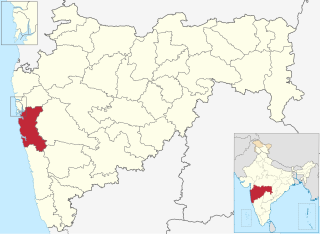
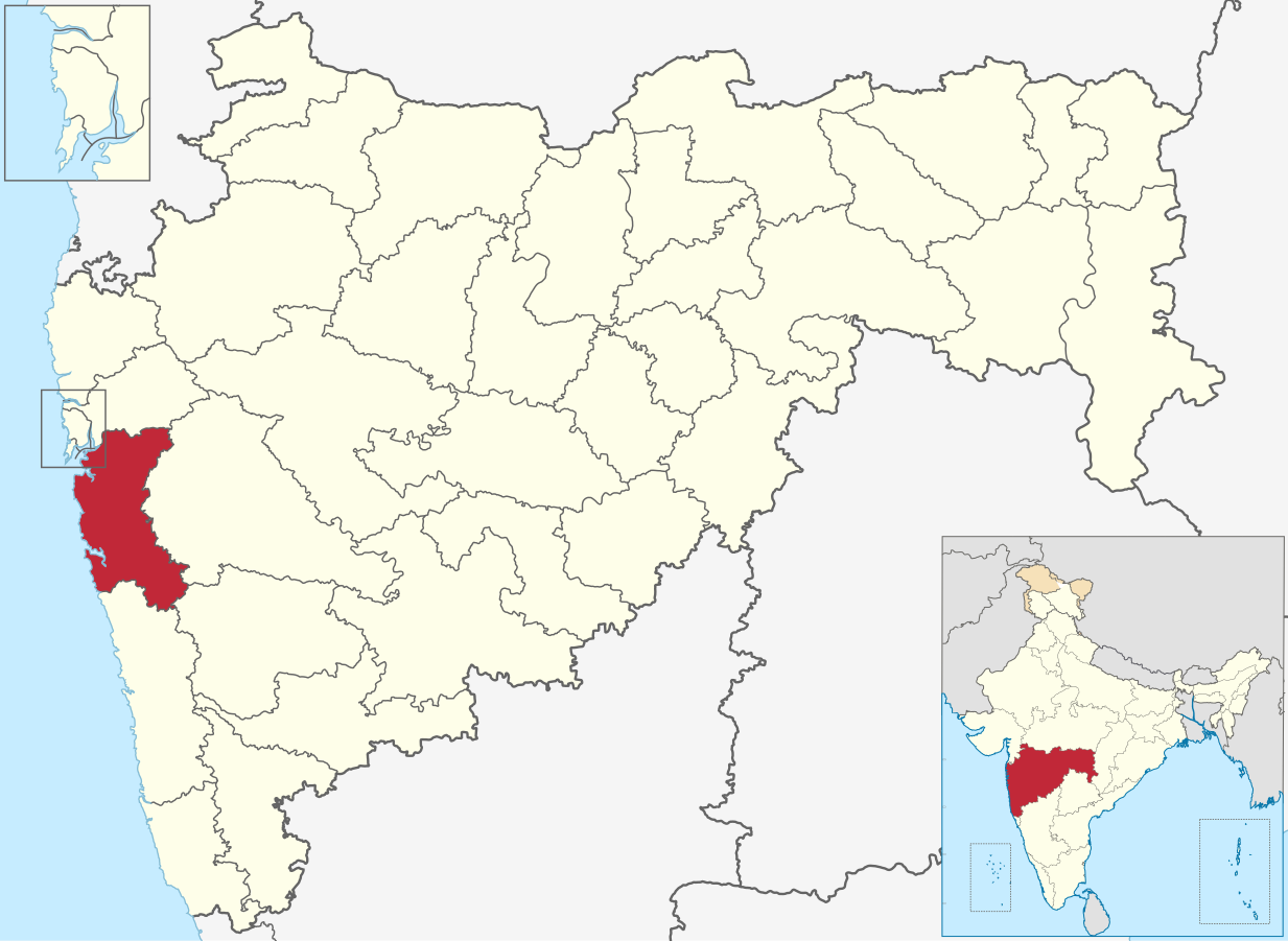
| Beschrijving | Map of Raigad district of Maharashtra |
| Datum | 2 March 2021 |
| Bron | Derivative of File:India Maharashtra location map.svg |
| Auteur | Own work based on User:Chumwa |
| Toestemming (Hergebruik van dit bestand) |
Dit bestand is gelicenseerd onder de Creative Commons-licentie Naamsvermelding-Gelijk delen 3.0 Unported
|
Category:Districts of Maharashtra
Bestandsgeschiedenis
Klik op een datum/tijd om het bestand te zien zoals het destijds was.
| Datum/tijd | Miniatuur | Afmetingen | Gebruiker | Opmerking | |
|---|---|---|---|---|---|
| huidige versie | 4 jul 2023 19:50 | | 1.233 × 901 (1,16 MB) | C1MM | updated bounds |
| 1 mei 2022 07:03 |  | 1.146 × 838 (805 kB) | C1MM | updated bounds | |
| 6 jun 2021 17:11 |  | 1.223 × 894 (1,24 MB) | C1MM | c bounds | |
| 3 mrt 2021 04:33 |  | 875 × 640 (767 kB) | C1MM | {{Information|Description=Map of Raigad district of Maharashtra|Source=Derivative of File:India Maharashtra location map.svg|Date=2 March 2021|Author=Own work based on User:Chumwa|Permission={{Cc-by-sa-3.0}}}} Category:Districts of Maharashtra |
Bestandsgebruik
Dit bestand wordt op de volgende pagina gebruikt:
Globaal bestandsgebruik
De volgende andere wiki's gebruiken dit bestand:
- Gebruikt op ar.wikipedia.org
- Gebruikt op arz.wikipedia.org
- Gebruikt op bn.wikipedia.org
- Gebruikt op ca.wikipedia.org
- Gebruikt op de.wikipedia.org
- Gebruikt op en.wikipedia.org
- Uran
- Alibag
- Matheran
- Karjat
- Roha
- Panvel
- Chaul
- Neral, India
- Kashid
- Revdanda
- Raigad district
- Khopoli
- Lonere
- Wahal
- Mahad
- Ambivali Tarf Tungaratan
- Birwadi
- Dhatau
- Kalundre
- Kegaon
- Kherdi
- Mhasla
- Mohpada
- Murud, Raigad
- Nagothane
- Poladpur
- Roha Ashtami
- Shrivardhan
- Taloje Panchnand
- Utekhol
- Sarasgad
- Rasayani
- Bamandongri
- Devale, Raigad
- Khalapur
- Mangaon
- Pen, India
- Pali, Raigad
- Mora, Maharashtra
- Shelu
- Chikhale, Panvel
- Rajpuri, Raigad
- Goregaon (Raigad)
- Bhivpuri
- Khandas
Globaal gebruik van dit bestand bekijken.
.svg)
.svg)