
Bestand:Santa-barbara-island-nps-map.PNG
Geen hogere resolutie beschikbaar.
Santa-barbara-island-nps-map.PNG (485 × 425 pixels, bestandsgrootte: 16 kB, MIME-type: image/png)
| Dit is een bestand van Wikimedia Commons. Onderstaande beschrijving komt van de beschrijving van het bestand daar. |
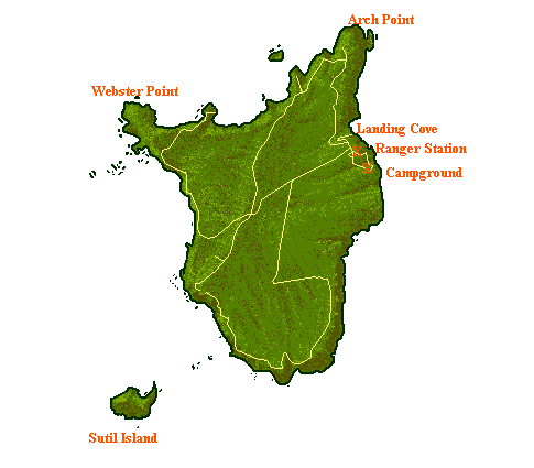
Beschrijving
- NPS map of Santa Barbara Island — in Channel Islands National Park, Southern California.
- Showing campgrounds, trails, access coves, and adjacent islets.
converted from .gif into .png format
| Dit beeld- of mediabestand bevat materiaal gebaseerd op een werk van een National Park Service medewerker, gemaakt als onderdeel van de officiële taken van die persoon. Als een werk van de Amerikaanse federale overheid, bevindt dergelijk werk zich in het publieke domein in de Verenigde Staten. Zie de NPS website en NPS copyright policy voor meer informatie. |
Bestandsgeschiedenis
Klik op een datum/tijd om het bestand te zien zoals het destijds was.
| Datum/tijd | Miniatuur | Afmetingen | Gebruiker | Opmerking | |
|---|---|---|---|---|---|
| huidige versie | 20 mei 2009 16:04 | | 485 × 425 (16 kB) | Telim tor | NPS map of Santa Barbara Island, converted from .gif into .png format {{PD-USGov-NPS}} Category:Santa Barbara Island Category:Channel Islands National Park Category:Maps of California <!--{{ImageUpload|basic}}--> |
Bestandsgebruik
Dit bestand wordt op de volgende pagina gebruikt:
Globaal bestandsgebruik
De volgende andere wiki's gebruiken dit bestand:
- Gebruikt op en.wikipedia.org
- Gebruikt op gl.wikipedia.org
- Gebruikt op it.wikipedia.org
- Gebruikt op pl.wikipedia.org