
Bestand:Satellite image of Flevopolder, Netherlands (5.48E 52.43N).png

Grootte van deze voorvertoning: 800 × 548 pixels. Andere resoluties: 320 × 219 pixels | 640 × 439 pixels | 1.024 × 702 pixels.
Oorspronkelijk bestand (1.024 × 702 pixels, bestandsgrootte: 1,49 MB, MIME-type: image/png)
| Dit is een bestand van Wikimedia Commons. Onderstaande beschrijving komt van de beschrijving van het bestand daar. |
.png)
| Beschrijving |
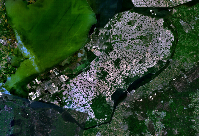
English: Satellite image of the Flevopolder in the Netherlands. Technically, the Flevopolder consists of Zuidelijk Flevoland (Southern Flevoland), Oostelijk Flevoland (Eastern Flevoland) and the Noordoostpolder (North Eastern Polder). This image shows Southern and Eastern Flevoland. |
| Bron | Screenshot from NASA's World Wind |
| Auteur | Foto: NASA |
| Deze afbeelding bevindt zich in het publiek domein omdat het een screenshot is van NASA’s software World Wind die gebruik maakt van een publiek domein-laag, zoals Blue Marble, MODIS, Landsat, SRTM, USGS of GLOBE.
|
 |
Bestandsgeschiedenis
Klik op een datum/tijd om het bestand te zien zoals het destijds was.
| Datum/tijd | Miniatuur | Afmetingen | Gebruiker | Opmerking | |
|---|---|---|---|---|---|
| huidige versie | 4 mei 2005 15:25 | | 1.024 × 702 (1,49 MB) | Galwaygirl | Satellite image of the Flevopolder in the Netherlands. Screenshot from NASA's World Wind {{PD}} |
Bestandsgebruik
Dit bestand wordt op de volgende 6 pagina's gebruikt:
Globaal bestandsgebruik
De volgende andere wiki's gebruiken dit bestand:
- Gebruikt op an.wikipedia.org
- Gebruikt op ar.wikipedia.org
- Gebruikt op ast.wikipedia.org
- Gebruikt op br.wikipedia.org
- Gebruikt op ca.wikipedia.org
- Gebruikt op cs.wikipedia.org
- Gebruikt op da.wikipedia.org
- Gebruikt op de.wikipedia.org
- Gebruikt op el.wikipedia.org
- Gebruikt op en.wikipedia.org
- Gebruikt op es.wikipedia.org
- Gebruikt op eu.wikipedia.org
- Gebruikt op fa.wikipedia.org
- Gebruikt op fr.wikipedia.org
- Gebruikt op gl.wikipedia.org
- Gebruikt op he.wikipedia.org
- Gebruikt op hr.wikipedia.org
- Gebruikt op hy.wikipedia.org
- Gebruikt op id.wikipedia.org
- Gebruikt op kk.wikipedia.org
- Gebruikt op ko.wikipedia.org
- Gebruikt op ms.wikipedia.org
- Gebruikt op no.wikipedia.org
- Gebruikt op oc.wikipedia.org
- Gebruikt op ro.wikipedia.org
- Gebruikt op ru.wikipedia.org
- Gebruikt op sh.wikipedia.org
- Gebruikt op simple.wikipedia.org
- Gebruikt op sr.wikipedia.org
- Gebruikt op ta.wikipedia.org
- Gebruikt op tr.wikipedia.org
- Gebruikt op uk.wikipedia.org
Globaal gebruik van dit bestand bekijken.
.png)
.png)