
Bestand:Scotland sections of Munro's tables.png

Grootte van deze voorvertoning: 433 × 599 pixels. Andere resoluties: 173 × 240 pixels | 347 × 480 pixels | 555 × 768 pixels | 740 × 1.024 pixels | 2.109 × 2.916 pixels.
Oorspronkelijk bestand (2.109 × 2.916 pixels, bestandsgrootte: 341 kB, MIME-type: image/png)
| Dit is een bestand van Wikimedia Commons. Onderstaande beschrijving komt van de beschrijving van het bestand daar. |
Beschrijving
| Beschrijving |
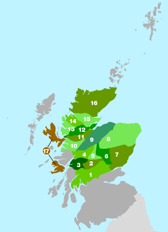
English: Rough outline of the areas used in Munro's 1891 tables to divide up the mountain ranges of Scotland. Map based on information in the 2006 edition of The Munros - SMC Hillwalkers' Guide ISBN 0907521940 |
| Bron | Eigen werk |
| Auteur | Cnbrb |
Licentie
| Ik, de auteursrechthebbende van dit werk, geef dit werk vrij in het publieke domein. Dit is wereldwijd van toepassing. In sommige landen is dit wettelijk niet mogelijk; in die gevallen geldt: Ik sta iedereen toe dit werk voor eender welk doel te gebruiken, zonder enige voorwaarden, tenzij zulke voorwaarden door de wet worden voorgeschreven. |
Bestandsgeschiedenis
Klik op een datum/tijd om het bestand te zien zoals het destijds was.
| Datum/tijd | Miniatuur | Afmetingen | Gebruiker | Opmerking | |
|---|---|---|---|---|---|
| huidige versie | 26 jul 2008 23:54 | | 2.109 × 2.916 (341 kB) | Cnbrb | {{Information |Description= English: English: Rough outline of the areas used in Munro's 1891 tables to divide up the mountain ranges of Scotland. Map based on information in the 2006 edition of The Munros - SMC Hillwalkers' Guide ISBN 0907521940 |Source |
| 27 jun 2008 22:00 |  | 600 × 828 (75 kB) | Cnbrb | {{Information |Description={{en|1=English: Rough outline of the areas used in Munro's 1891 tables to divide up the mountain ranges of Scotland. Map based on information in the 2006 edition of '''The Munros - SMC Hillwalkers' Guide''' ISBN 0907521940}} |So |
Bestandsgebruik
Dit bestand wordt op de volgende pagina gebruikt:
Globaal bestandsgebruik
De volgende andere wiki's gebruiken dit bestand:
- Gebruikt op bg.wikipedia.org
- Gebruikt op cy.wikipedia.org
- Gebruikt op de.wikipedia.org
- Gebruikt op en.wikipedia.org
- Gebruikt op es.wikipedia.org
- Gebruikt op eu.wikipedia.org
- Gebruikt op ga.wikipedia.org
- Gebruikt op it.wikipedia.org
- Gebruikt op nn.wikipedia.org
- Gebruikt op no.wikipedia.org
- Gebruikt op www.wikidata.org