
Bestand:SeamontDavidson expedition bathymetric-2002.jpg
Geen hogere resolutie beschikbaar.
SeamontDavidson_expedition_bathymetric-2002.jpg (600 × 478 pixels, bestandsgrootte: 59 kB, MIME-type: image/jpeg)
| Dit is een bestand van Wikimedia Commons. Onderstaande beschrijving komt van de beschrijving van het bestand daar. |
Beschrijving
| Beschrijving |
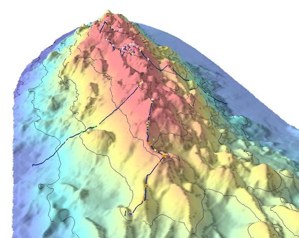
English: Bathymetric showing details of part of Davidson Seamount. The lines indicate the path of the 2002 expedition, and the dots signifigant coral nurseries
Français : Relevé bathymétrique montrant les détails du relief sous-marin du Mont Davidson. les lignes indiquent les lieux étudiés par l'expédition de 2002, et les points désignent les surseries coralliennes |
| Datum | import on Commons : 2010/10/30 |
| Bron | Direct link File page |
| Auteur | C. King/[1]/[2] |
| Toestemming (Hergebruik van dit bestand) |
The above two organizations are a part of NOAA; thus it is public domain (see below) |
Licentie
Deze afbeelding is in het publiek domein omdat het materiaal bevat dat oorspronkelijk van de National Oceanic and Atmospheric Administration kwam in de Verenigde Staten en genomen of gemaakt is tijdens de officiële werkzaamheden van een werknemer.
|
Bestandsgeschiedenis
Klik op een datum/tijd om het bestand te zien zoals het destijds was.
| Datum/tijd | Miniatuur | Afmetingen | Gebruiker | Opmerking | |
|---|---|---|---|---|---|
| huidige versie | 30 okt 2010 10:21 | | 600 × 478 (59 kB) | Lamiot | {{Information |Description= {{en|Bathymetric showing details of part of Davidson Seamount. The lines indicate the path of the 2002 expedition, and the dots signifigant coral nurseries}} {{fr|Relevé bathymétrique montrant les détails du relief sous-mari |
Bestandsgebruik
Dit bestand wordt op de volgende pagina gebruikt:
Globaal bestandsgebruik
De volgende andere wiki's gebruiken dit bestand:
- Gebruikt op bs.wikipedia.org
- Gebruikt op en.wikipedia.org
- Gebruikt op fa.wikipedia.org
- Gebruikt op fr.wikipedia.org
- Gebruikt op gl.wikipedia.org
- Gebruikt op he.wikipedia.org
- Gebruikt op mk.wikipedia.org
- Gebruikt op simple.wikipedia.org
- Gebruikt op sr.wikipedia.org
- Gebruikt op th.wikipedia.org
- Gebruikt op tr.wikipedia.org
- Gebruikt op tt.wikipedia.org
- Gebruikt op www.wikidata.org