
Bestand:Sears Point California aerial view.jpg

Grootte van deze voorvertoning: 800 × 533 pixels. Andere resoluties: 320 × 213 pixels | 640 × 427 pixels | 1.024 × 683 pixels | 1.500 × 1.000 pixels.
Oorspronkelijk bestand (1.500 × 1.000 pixels, bestandsgrootte: 590 kB, MIME-type: image/jpeg)
| Dit is een bestand van Wikimedia Commons. Onderstaande beschrijving komt van de beschrijving van het bestand daar. |
| Beschrijving |
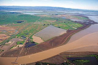
English: Sears Point in Sonoma County, California, USA. Sears Point is the end of a range of hills or low mountains ending at the northern end of San Pablo Bay and the Napa Sonoma Marsh, which is the flat marshy land across the picture. The Petaluma River flows into the bay at the bottom of the picture.
Coordinates: 38°9′3.46″N 122°27′8.99″W / 38.1509611°N 122.4524972°W |
|||
| Locatie | Sonoma County, California, USA | |||
| Datum | not specified or unknown | |||
| Bron |
U.S. Army Corps of Engineers Digital Visual Library Image page Image description page Digital Visual Library home page |
|||
| Auteur | U.S. Army Corps of Engineers, photographer not specified or unknown | |||
| Toestemming (Hergebruik van dit bestand) |
|
Bestandsgeschiedenis
Klik op een datum/tijd om het bestand te zien zoals het destijds was.
| Datum/tijd | Miniatuur | Afmetingen | Gebruiker | Opmerking | |
|---|---|---|---|---|---|
| huidige versie | 4 mei 2007 06:11 | | 1.500 × 1.000 (590 kB) | DanMS | {{Information | Description = {{en|Sears Point in Sonoma County, California, USA. Sears Point is the end of a range of hills or low mountains ending at the northern end of San Pablo Bay and the Napa Sonoma Marsh, which is the flat marshy land across th |
Bestandsgebruik
Dit bestand wordt op de volgende pagina gebruikt:
Globaal bestandsgebruik
De volgende andere wiki's gebruiken dit bestand:
- Gebruikt op en.wikipedia.org
- Gebruikt op www.wikidata.org