
Bestand:Slovakia1941 02.png
Grootte van deze voorvertoning: 794 × 600 pixels. Andere resoluties: 318 × 240 pixels | 636 × 480 pixels | 997 × 753 pixels.
Oorspronkelijk bestand (997 × 753 pixels, bestandsgrootte: 50 kB, MIME-type: image/png)
| Dit is een bestand van Wikimedia Commons. Onderstaande beschrijving komt van de beschrijving van het bestand daar. |
Beschrijving
| Beschrijving |
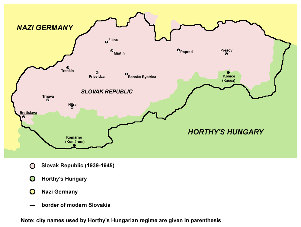
English: historic map of Slovak Republic (1939-1945) |
| Datum | 28 december 2006 (originele uploaddatum) |
| Bron | Eigen werk |
| Auteur | PANONIAN |
| Andere versies |
[]
|


.png)

References
Published references:
- The Times History of Europe, Times Books, London, 2002.
- Richard Overy, The Times History of the 20th Century, Times Books, London, 2003.
- Istorijski atlas, Zavod za udžbenike i nastavna sredstva - Zavod za kartografiju "Geokarta", Beograd, 1999.
- Peter Rokai - Zoltan Đere - Tibor Pal - Aleksandar Kasaš, Istorija Mađara, Beograd, 2002.
Internet references:
Licentie
self made map by user:PANONIAN

|
This map has been uploaded by Electionworld from en.wikipedia.org to enable the |
| Ik, de auteursrechthebbende van dit werk, geef dit werk vrij in het publieke domein. Dit is wereldwijd van toepassing. In sommige landen is dit wettelijk niet mogelijk; in die gevallen geldt: Ik sta iedereen toe dit werk voor eender welk doel te gebruiken, zonder enige voorwaarden, tenzij zulke voorwaarden door de wet worden voorgeschreven. |
derivative works
Afgeleide werken van dit bestand:
Bestandsgeschiedenis
Klik op een datum/tijd om het bestand te zien zoals het destijds was.
| Datum/tijd | Miniatuur | Afmetingen | Gebruiker | Opmerking | |
|---|---|---|---|---|---|
| huidige versie | 29 apr 2011 11:43 | | 997 × 753 (50 kB) | Piastu | Reverted to version as of 10:58, 5 March 2011 |
| 29 apr 2011 11:33 |  | 794 × 600 (95 kB) | Damianwiszowaty12 | Translate words in picture. | |
| 5 mrt 2011 12:58 |  | 997 × 753 (50 kB) | PANONIAN | aesthetical correction | |
| 22 aug 2009 19:04 |  | 997 × 753 (50 kB) | PANONIAN | ||
| 22 aug 2009 16:02 |  | 997 × 662 (46 kB) | PANONIAN | ||
| 28 dec 2006 18:25 |  | 773 × 448 (8 kB) | Electionworld | {{ew|en|PANONIAN}} historic map of Slovakia (self made) {{PD-self}} Category:Maps of the history of Slovakia Category:Maps of World War II in Europe |
Bestandsgebruik
Dit bestand wordt op de volgende pagina gebruikt:
Globaal bestandsgebruik
De volgende andere wiki's gebruiken dit bestand:
- Gebruikt op an.wikipedia.org
- Gebruikt op azb.wikipedia.org
- Gebruikt op be-tarask.wikipedia.org
- Gebruikt op be.wikipedia.org
- Gebruikt op bg.wikipedia.org
- Gebruikt op bs.wikipedia.org
- Gebruikt op ca.wikipedia.org
- Gebruikt op cs.wikipedia.org
- Gebruikt op cv.wikipedia.org
- Gebruikt op da.wikipedia.org
- Gebruikt op de.wikipedia.org
- Gebruikt op el.wikipedia.org
- Gebruikt op en.wikipedia.org
- Gebruikt op eo.wikipedia.org
- Gebruikt op et.wikipedia.org
- Gebruikt op fa.wikipedia.org
- Gebruikt op fo.wikipedia.org
- Gebruikt op fr.wikipedia.org
- Gebruikt op he.wikipedia.org
- Gebruikt op hr.wikipedia.org
- Gebruikt op hu.wikipedia.org
- Gebruikt op id.wikipedia.org
- Gebruikt op is.wikipedia.org
- Gebruikt op it.wikipedia.org
- Gebruikt op ja.wikipedia.org
- Gebruikt op jv.wikipedia.org
- Gebruikt op ko.wikipedia.org
- Gebruikt op lt.wikipedia.org
- Gebruikt op no.wikipedia.org
- Gebruikt op pl.wikipedia.org
- Gebruikt op pt.wikipedia.org
- Gebruikt op ro.wikipedia.org
- Gebruikt op sh.wikipedia.org
Globaal gebruik van dit bestand bekijken.