
Bestand:St Lawrence, Fulstow - geograph.org.uk - 433108.jpg
Geen hogere resolutie beschikbaar.
St_Lawrence,_Fulstow_-_geograph.org.uk_-_433108.jpg (640 × 480 pixels, bestandsgrootte: 81 kB, MIME-type: image/jpeg)
| Dit is een bestand van Wikimedia Commons. Onderstaande beschrijving komt van de beschrijving van het bestand daar. |
Beschrijving
| Beschrijving |
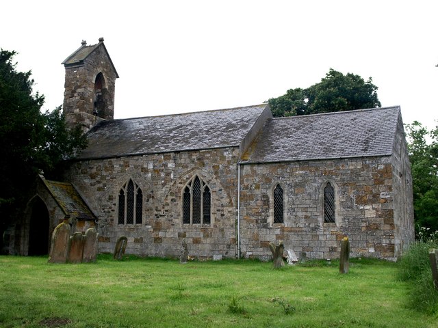
English: St Lawrence, Fulstow The walls of the church of St Lawrence have the remains of arcades, which point to the fact that there were north and south aisles and that this building comes from the Early English period - about 1160 to 1180. There are the remains of three bays on the outer wall of the south side and two on the north. The font is also Early English. Inside the porch entrance are two 14th century effigies of a cross-legged knight, Sir Robert de Hilton, and his lady.
On this day, a note in the porch read, "St Lawrence and Flower Cleaning Roaster." I guess it should have said, "Flower Arranging and Cleaning Roster". |
| Datum | |
| Bron | From geograph.org.uk |
| Auteur | Dave Hitchborne |
| Naamsvermelding (required by the license) | Dave Hitchborne / St Lawrence, Fulstow / |
| Cameralocatie | | Deze en andere afbeeldingen in: OpenStreetMap |
|---|
_heading:337.00&language=nl)
| Objectlocatie | | Deze en andere afbeeldingen in: OpenStreetMap |
|---|
_heading:337.00&language=nl)
Licentie

|
Deze afbeelding komt uit de Geograph British Isles-collectie. Zie de pagina van deze foto op de website van Geograph voor contactinformatie van de fotograaf. Het auteursrecht van deze foto is in handen van Dave Hitchborne en de foto is gelicenceerd voor hergebruik onder de Creative Commons Naamsvermelding-Gelijk delen 2.0 licentie.
|
Dit bestand is gelicenseerd onder de Creative Commons-licentie Naamsvermelding-Gelijk delen 2.0 Unported
Naamsvermelding: Dave Hitchborne
- De gebruiker mag:
- Delen – het werk kopiëren, verspreiden en doorgeven
- Remixen – afgeleide werken maken
- Onder de volgende voorwaarden:
- naamsvermelding – U moet op een gepaste manier aan naamsvermelding doen, een link naar de licentie geven, en aangeven of er wijzigingen in het werk zijn aangebracht. U mag dit op elke redelijke manier doen, maar niet zodanig dat de indruk wordt gewekt dat de licentiegever instemt met uw werk of uw gebruik van zijn werk.
- Gelijk delen – Als u het werk heeft geremixt, veranderd, of erop heeft voortgebouwd, moet u het gewijzigde materiaal verspreiden onder dezelfde licentie als het oorspronkelijke werk, of een daarmee compatibele licentie.
Bestandsgeschiedenis
Klik op een datum/tijd om het bestand te zien zoals het destijds was.
| Datum/tijd | Miniatuur | Afmetingen | Gebruiker | Opmerking | |
|---|---|---|---|---|---|
| huidige versie | 4 feb 2011 11:03 | | 640 × 480 (81 kB) | GeographBot | == {{int:filedesc}} == {{Information |description={{en|1=St Lawrence, Fulstow The walls of the church of St Lawrence have the remains of arcades, which point to the fact that there were north and south aisles and that this building comes from the Early En |
Bestandsgebruik
Dit bestand wordt op de volgende pagina gebruikt:
Globaal bestandsgebruik
De volgende andere wiki's gebruiken dit bestand:
- Gebruikt op ceb.wikipedia.org
- Gebruikt op cy.wikipedia.org
- Gebruikt op en.wikipedia.org
- Gebruikt op es.wikipedia.org
- Gebruikt op fa.wikipedia.org
- Gebruikt op fr.wikipedia.org
- Gebruikt op it.wikipedia.org
- Gebruikt op lld.wikipedia.org
- Gebruikt op www.wikidata.org