
Bestand:Tannenberg3008.jpg
Grootte van deze voorvertoning: 775 × 600 pixels. Andere resoluties: 310 × 240 pixels | 620 × 480 pixels | 993 × 768 pixels | 1.242 × 961 pixels.
Oorspronkelijk bestand (1.242 × 961 pixels, bestandsgrootte: 207 kB, MIME-type: image/jpeg)
| Dit is een bestand van Wikimedia Commons. Onderstaande beschrijving komt van de beschrijving van het bestand daar. |

|
Bestand:East Prussian Campaign (27—30 Aug 1914) - ru.svg is een vectorversie van dit bestand. Indien niet van slechtere kwaliteit dient deze gebruikt te worden in plaats van deze rasterafbeelding.
File:Tannenberg3008.jpg → File:East Prussian Campaign (27—30 Aug 1914) - ru.svg
Zie Help:SVG voor meer informatie. |
_-_ru.svg) |
| Beschrijving |
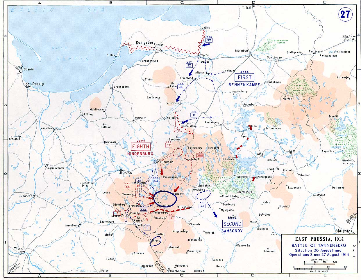
English: Battle of Tannenberg (1914) in its last phase |
| Bron |
Taken from the campaign series, made public by the US-Army under dean.usma.edu
|
| Auteur | US-Army under www.dean.usma.edu |
| Toestemming (Hergebruik van dit bestand) |
The picture is public domain. |
Deze afbeelding is een werk van een soldaat of werknemer van de U.S. Army, genomen of gemaakt tijdens de uitvoering van diens officiële taken. Als werk van de federale overheid van de Verenigde Staten bevindt deze afbeelding zich in het publiek domein.
|
 |
Bestandsgeschiedenis
Klik op een datum/tijd om het bestand te zien zoals het destijds was.
| Datum/tijd | Miniatuur | Afmetingen | Gebruiker | Opmerking | |
|---|---|---|---|---|---|
| huidige versie | 22 sep 2005 16:29 | | 1.242 × 961 (207 kB) | Nasiruddin | Taken from the campaign series, made public by the US-Army under www.dean.usma.edu The öpicture is public domain. It shows the battle of Tannenberg in its last phase {{PD-USGov-Military-Army}} Category:World War I maps |
Bestandsgebruik
Dit bestand wordt op de volgende pagina gebruikt:
Globaal bestandsgebruik
De volgende andere wiki's gebruiken dit bestand:
- Gebruikt op be-tarask.wikipedia.org
- Gebruikt op be.wikipedia.org
- Gebruikt op ca.wikipedia.org
- Gebruikt op cs.wikipedia.org
- Gebruikt op da.wikipedia.org
- Gebruikt op de.wikipedia.org
- Gebruikt op el.wikipedia.org
- Gebruikt op en.wikipedia.org
- Gebruikt op et.wikipedia.org
- Gebruikt op fi.wikipedia.org
- Gebruikt op fr.wikipedia.org
- Gebruikt op he.wikipedia.org
- Gebruikt op hr.wikipedia.org
- Gebruikt op it.wikipedia.org
- Gebruikt op ja.wikipedia.org
- Gebruikt op ko.wikipedia.org
- Gebruikt op lv.wikipedia.org
- Gebruikt op no.wikipedia.org
- Gebruikt op pl.wikipedia.org
- Gebruikt op sv.wikipedia.org
- Gebruikt op uk.wikipedia.org
- Gebruikt op vi.wikipedia.org
- Gebruikt op zh.wikipedia.org