
Bestand:Via domitia map600x600 (1).png
Geen hogere resolutie beschikbaar.
Via_domitia_map600x600_(1).png (600 × 600 pixels, bestandsgrootte: 58 kB, MIME-type: image/png)
| Dit is een bestand van Wikimedia Commons. Onderstaande beschrijving komt van de beschrijving van het bestand daar. |
.png)
Beschrijving
| Beschrijving |
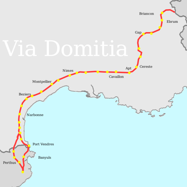
English: Thomas Miles, made on the gimp, consulting several maps, using wikipedia's blank France Map as template |
| Datum | 17 mei 2007 (originele uploaddatum) |
| Bron | Verplaatst vanaf en.wikipedia naar Commons. |
| Auteur | T L Miles op de Engelstalige Wikipedia |
Licentie
| Dit werk vrijgegeven in het publieke domein door de auteur, T L Miles op de Engelstalige Wikipedia. Dit is wereldwijd van toepassing. In sommige landen is dit wettelijk niet mogelijk; in die gevallen geldt: T L Miles staat iedereen toe dit werk voor eender welk doel te gebruiken, zonder enige voorwaarden, tenzij zulke voorwaarden door de wet worden voorgeschreven. |
Oorspronkelijk uploadlogboek
De oorspronkelijke beschrijving van deze afbeelding stond hier. Alle volgende gebruikersnamen verwijzen naar en.wikipedia.
- 2007-05-17 19:01 T L Miles 600×600×8 (58888 bytes) Thomas Miles, made on the gimp, consulting several maps, using wikipedia's blank France Map as template
Bestandsgeschiedenis
Klik op een datum/tijd om het bestand te zien zoals het destijds was.
| Datum/tijd | Miniatuur | Afmetingen | Gebruiker | Opmerking | |
|---|---|---|---|---|---|
| huidige versie | 7 apr 2008 21:50 | | 600 × 600 (58 kB) | File Upload Bot (Magnus Manske) | {{BotMoveToCommons|en.wikipedia}} {{Information |Description={{en|Thomas Miles, made on the gimp, consulting several maps, using wikipedia's blank France Map as template}} |Source=Transferred from [http://en.wikipedia.org en.wikipedia] |Date=2007-05-17 ( |
Bestandsgebruik
Dit bestand wordt op de volgende pagina gebruikt:
Globaal bestandsgebruik
De volgende andere wiki's gebruiken dit bestand:
- Gebruikt op bg.wikipedia.org
- Gebruikt op ca.wikipedia.org
- Gebruikt op cs.wikipedia.org
- Gebruikt op da.wikipedia.org
- Gebruikt op de.wikipedia.org
- Gebruikt op el.wikipedia.org
- Gebruikt op en.wikipedia.org
- Gebruikt op es.wikipedia.org
- Gebruikt op eu.wikipedia.org
- Gebruikt op fi.wikipedia.org
- Gebruikt op fr.wikipedia.org
- Voie Domitienne
- Durance
- Histoire du département de Vaucluse
- Histoire de l'Occitanie
- Histoire de Marseillan (Hérault)
- Forcalquier
- Apta Julia
- Wikipédia:Atelier graphique/Cartes/Archives/juillet 2011
- Histoire de Forcalquier
- Voie héracléenne
- Ebrodunensium
- Discussion:Liste des monuments historiques protégés en 1840/Wikidata
- Gebruikt op it.wikipedia.org
- Gebruikt op ja.wikipedia.org
- Gebruikt op ja.wikibooks.org
- Gebruikt op ko.wikipedia.org
- Gebruikt op mk.wikipedia.org
- Gebruikt op no.wikipedia.org
- Gebruikt op ro.wikipedia.org
- Gebruikt op ru.wikipedia.org
- Gebruikt op sl.wikipedia.org
- Gebruikt op uk.wikipedia.org
- Gebruikt op www.wikidata.org
- Gebruikt op zh.wikipedia.org
.png)