
Bestand:View of Vicksburg.jpg
Oorspronkelijk bestand (6.552 × 5.024 pixels, bestandsgrootte: 4,94 MB, MIME-type: image/jpeg)
Onderstaande beschrijving komt van de beschrijving van het bestand daar.
Beschrijving
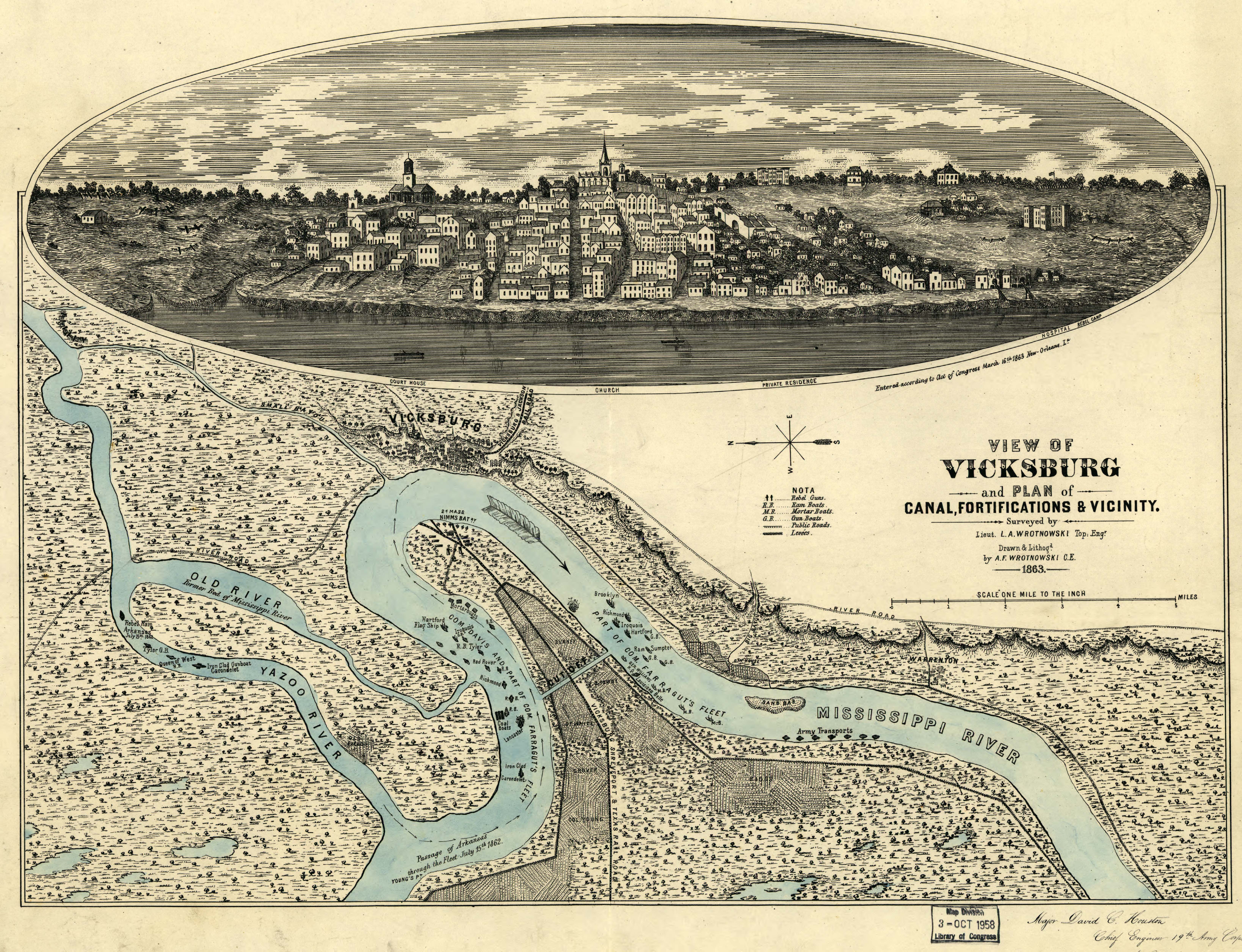
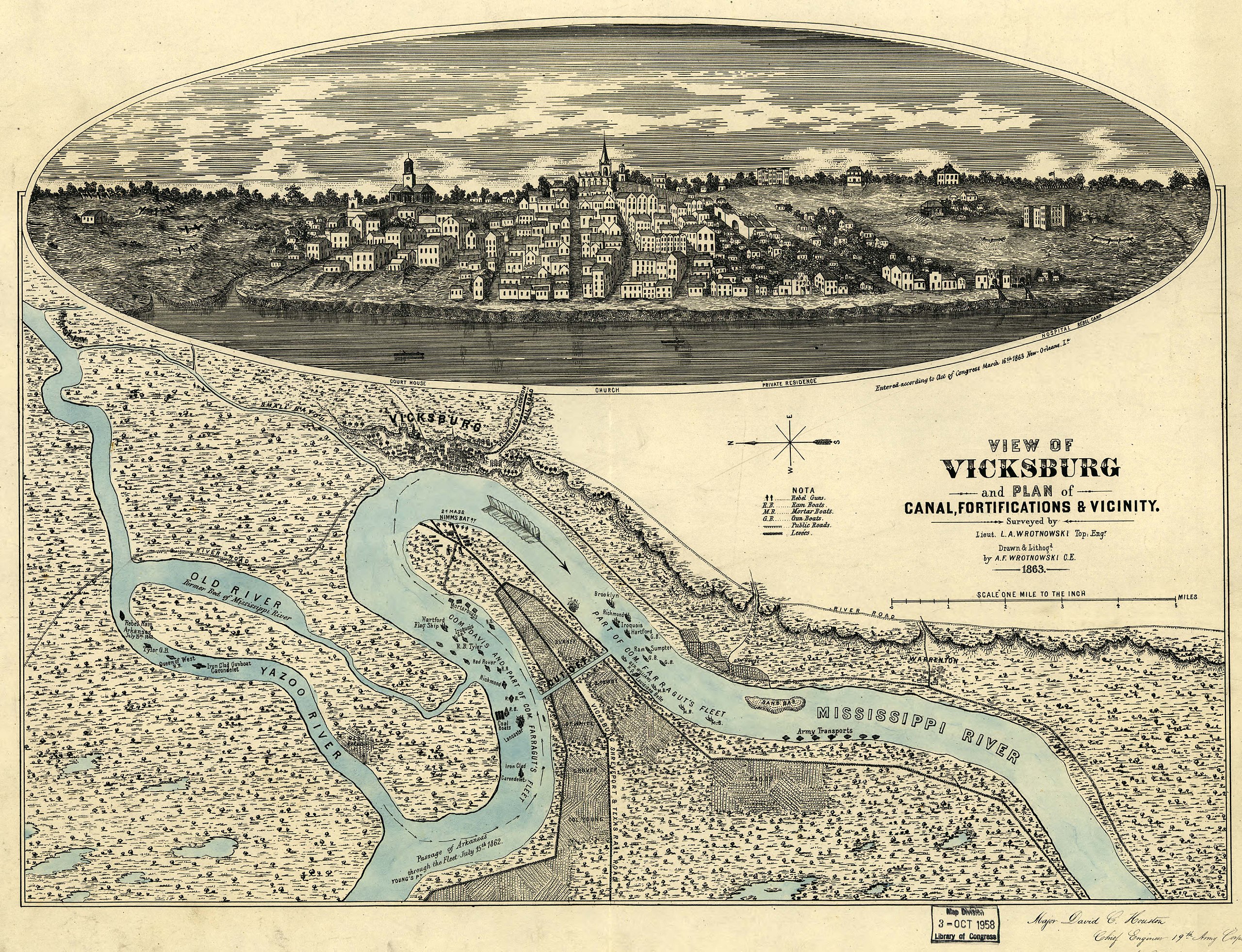
View of Vicksburg, Mississippi, 1863, during the American Civil War
Original work
View of Vicksburg and plan of the canal, fortifications & vicinity Surveyed by Lieut. L. A. Wrotnowski, Top: Engr. Drawn & lithogd. by A. F. Wrotnowski C.E.
Wrotnowski, L. A.
CREATED/PUBLISHED [S.l.], 1863.
NOTES Scale 1:63,360.
Reference: LC Civil War Maps (2nd ed.), 294
Indicates fortifications, location, type and names of boats, roads, railroads, levees, drainage, vegetation, and the names of a few residents.
Inset: [View of Vicksburg] 17 x 54 cm.
Inscribed in the lower right hand corner "Major David C. Houston, Chief Engineer, 19th Army Corps, with the compliments from the author."
Description derived from published bibliography.
SUBJECTS
Vicksburg (Miss.)--History--Civil War, 1861-1865--Maps.
United States--Mississippi--Vicksburg.
MEDIUM 1 view, col., 40 x 54 cm.
CALL NUMBER G3984.V8S5 1863 .W7 CW 294
REPOSITORY Library of Congress Geography and Map Division Washington, D.C. 20540-4650
DIGITAL ID g3984v cw0294000 http://hdl.loc.gov/loc.gmd/g3984v.cw0294000
Licentie
Deze afbeelding is een werk van een soldaat of werknemer van de U.S. Army, genomen of gemaakt tijdens de uitvoering van diens officiële taken. Als werk van de federale overheid van de Verenigde Staten bevindt deze afbeelding zich in het publiek domein.
|
 |
Bestandsgeschiedenis
Klik op een datum/tijd om het bestand te zien zoals het destijds was.
| Datum/tijd | Miniatuur | Afmetingen | Gebruiker | Opmerking | |
|---|---|---|---|---|---|
| huidige versie | 3 aug 2007 01:57 | | 6.552 × 5.024 (4,94 MB) | Kkmurray | ==Original work== [http://lcweb2.loc.gov/cgi-bin/query/r?ammem/aaodyssey,gmd,fmuever,mmorse,upboverbib:@field(NUMBER+@band(g3984v+cw0294000))] View of Vicksburg and plan of the canal, fortifications & vicinity Surveyed by Lieut. L. A. Wrotnowski, Top: E |
Bestandsgebruik
Dit bestand wordt op de volgende pagina gebruikt:
Globaal bestandsgebruik
De volgende andere wiki's gebruiken dit bestand:
- Gebruikt op azb.wikipedia.org
- Gebruikt op da.wikipedia.org
- Gebruikt op en.wikipedia.org
- Gebruikt op fa.wikipedia.org
- Gebruikt op fr.wikipedia.org
- Gebruikt op he.wikipedia.org
- Gebruikt op hu.wikipedia.org
- Gebruikt op ja.wikipedia.org
- Gebruikt op pl.wikipedia.org
- Gebruikt op sh.wikipedia.org
- Gebruikt op zh.wikipedia.org