
Bestand:Belgium - Location Map (2013) - BEL - UNOCHA.svg

Oorspronkelijk bestand (SVG-bestand, nominaal 254 × 254 pixels, bestandsgrootte: 905 kB)
| Dit is een bestand van Wikimedia Commons. Onderstaande beschrijving komt van de beschrijving van het bestand daar. |
_-_BEL_-_UNOCHA.svg)
Beschrijving
| Beschrijving |
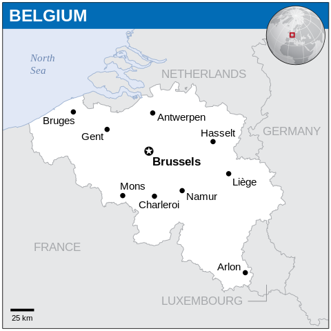
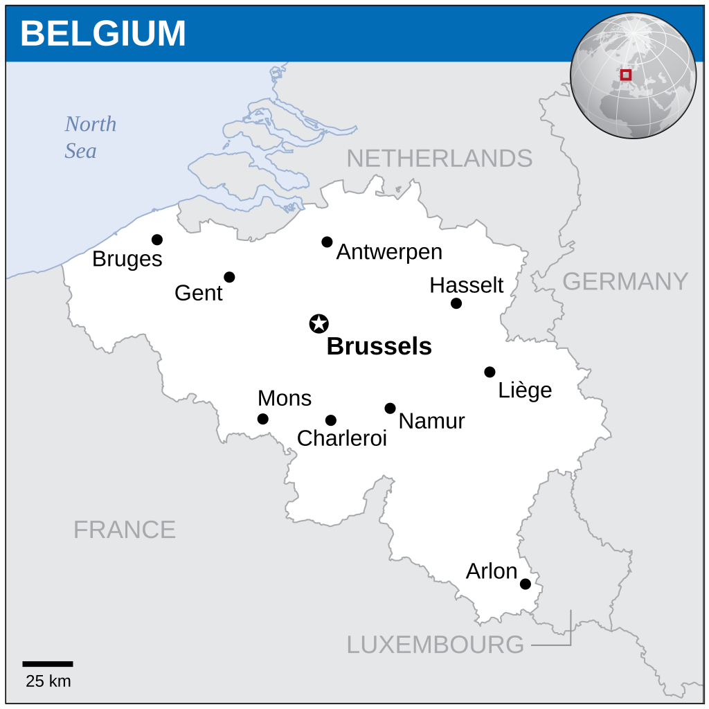
English: Locator map of Belgium. |
| Datum | |
| Bron |
English: Belgium Locator Map (ReliefWeb), ESRI, UNCS |
| Auteur | |
| SVG ontwikkeling | De broncode van dit SVG-bestand is deugdelijk. |
Licentie
- De gebruiker mag:
- Delen – het werk kopiëren, verspreiden en doorgeven
- Remixen – afgeleide werken maken
- Onder de volgende voorwaarden:
- naamsvermelding – U moet op een gepaste manier aan naamsvermelding doen, een link naar de licentie geven, en aangeven of er wijzigingen in het werk zijn aangebracht. U mag dit op elke redelijke manier doen, maar niet zodanig dat de indruk wordt gewekt dat de licentiegever instemt met uw werk of uw gebruik van zijn werk.
 This map is part of a collection of 216 free country maps, created by the UN Office for the Coordination of Humanitarian Affairs (OCHA), to be used in print, web or broadcast products.
The ReliefWeb Location Maps released here are maps that highlight a country, its capital, major populated places and the surrounding regions. Attribution Requirements
Using the map without modifications: ensure that the sources and the disclaimer are below the map. Credit as follows: "Credit: OCHA". For use with alteration: remove the OCHA logo and disclaimer following any modification to the map, but keep the data sources as mentioned below the map. Credit the modified map as follows: "Based on OCHA map". You are responsible for the content of your map. We are keen to receive your feedback and hear how you used OCHA's maps. We would be grateful if you would notify us by e-mail and share your work with us. UN Disclaimer
The designations employed and the presentation of material of this map do not imply the expression of any opinion whatsoever on the part of the Secretariat of the United Nations concerning the legal status of any country, territory, city or area or of its authorities or concerning the delimitation of its frontiers or boundaries. |
Bestandsgeschiedenis
Klik op een datum/tijd om het bestand te zien zoals het destijds was.
| Datum/tijd | Miniatuur | Afmetingen | Gebruiker | Opmerking | |
|---|---|---|---|---|---|
| huidige versie | 4 feb 2024 19:21 | | 254 × 254 (905 kB) | Illchy | File uploaded using svgtranslate tool (https://svgtranslate.toolforge.org/). Added translation for id. |
| 7 nov 2014 21:33 |  | 254 × 254 (904 kB) | GermanJoe | watermark removed | |
| 14 mrt 2014 00:26 |  | 254 × 254 (948 kB) | UN OCHA maps bot | == {{int:filedesc}} == {{Information |description={{en|1=Locator Map of Belgium. {{OCHA map}}}} |date=2013 |source=[http://reliefweb.int/map/belgium/belgium-location-map-2013 Belgium Locator Map (ReliefWeb)] |author=[[w:United Nations Off... |
Bestandsgebruik
Geen enkele pagina gebruikt dit bestand.
Globaal bestandsgebruik
De volgende andere wiki's gebruiken dit bestand:
- Gebruikt op az.wiktionary.org
- Gebruikt op ban.wikipedia.org
- Gebruikt op bh.wikipedia.org
- Gebruikt op csb.wikipedia.org
- Gebruikt op es.wikipedia.org
- Gebruikt op eu.wikipedia.org
- Gebruikt op fa.wikipedia.org
- Gebruikt op id.wikipedia.org
- Gebruikt op incubator.wikimedia.org
- Gebruikt op ka.wikipedia.org
- Gebruikt op min.wikipedia.org
- Gebruikt op mk.wikipedia.org
- Gebruikt op ml.wikipedia.org
- Gebruikt op mwl.wikipedia.org
- Gebruikt op sco.wikipedia.org
- Gebruikt op sh.wikipedia.org
- Gebruikt op simple.wikipedia.org
- Gebruikt op so.wikipedia.org
- Gebruikt op te.wikipedia.org
- Gebruikt op trv.wikipedia.org
- Gebruikt op ur.wikipedia.org
_-_BEL_-_UNOCHA.svg)