
Bestand:Periferia Ipirou.png

Grootte van deze voorvertoning: 706 × 599 pixels. Andere resoluties: 283 × 240 pixels | 566 × 480 pixels.
Oorspronkelijk bestand (800 × 679 pixels, bestandsgrootte: 92 kB, MIME-type: image/png)
| Dit is een bestand van Wikimedia Commons. Onderstaande beschrijving komt van de beschrijving van het bestand daar. |
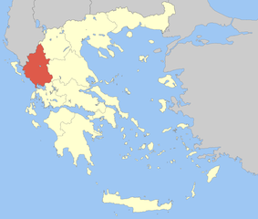
| Beschrijving | Locator Map of Epirus Periphery, Greece |
| Datum | |
| Bron | Eigen werk |
| Auteur | Pitichinaccio |
| Ik, de auteursrechthebbende van dit werk, geef dit werk vrij in het publieke domein. Dit is wereldwijd van toepassing. In sommige landen is dit wettelijk niet mogelijk; in die gevallen geldt: Ik sta iedereen toe dit werk voor eender welk doel te gebruiken, zonder enige voorwaarden, tenzij zulke voorwaarden door de wet worden voorgeschreven. |
Bestandsgeschiedenis
Klik op een datum/tijd om het bestand te zien zoals het destijds was.
| Datum/tijd | Miniatuur | Afmetingen | Gebruiker | Opmerking | |
|---|---|---|---|---|---|
| huidige versie | 5 apr 2008 13:47 | | 800 × 679 (92 kB) | Pitichinaccio | {{Information |Description=Locator Map of Epirus Periphery, Greece |Source=eigene Arbeit |Date=April 5, 2008 |Author= Pitichinaccio }} {{PD-self}} Category:Periphery maps of Greece |
Bestandsgebruik
Geen enkele pagina gebruikt dit bestand.
Globaal bestandsgebruik
De volgende andere wiki's gebruiken dit bestand:
- Gebruikt op ay.wikipedia.org
- Gebruikt op ceb.wikipedia.org
- Gebruikt op da.wikipedia.org
- Gebruikt op de.wikipedia.org
- Gebruikt op el.wikipedia.org
- Gebruikt op en.wikipedia.org
- Dodoni
- Arta (regional unit)
- Ioannina
- Preveza
- Thesprotia
- Metsovo
- Konitsa
- Parga
- Zagori
- Souli
- Ioannina (regional unit)
- Preveza (regional unit)
- Arta, Greece
- Igoumenitsa
- Epirus (region)
- Georgios Karaiskakis (municipality)
- Filiates
- Zitsa
- Template:Epirus Region
- North Tzoumerka
- Pogoni
- Central Tzoumerka
- Nikolaos Skoufas (municipality)
- Ziros, Preveza
- Gebruikt op fa.wikipedia.org
- Gebruikt op fr.wikipedia.org
Globaal gebruik van dit bestand bekijken.