
Bestand:Stielers Handatlas 1891 59.jpg
Oorspronkelijk bestand (5.050 × 4.250 pixels, bestandsgrootte: 7,62 MB, MIME-type: image/jpeg)
| Dit is een bestand van Wikimedia Commons. Onderstaande beschrijving komt van de beschrijving van het bestand daar. |
| Let op | Sommige browsers kunnen mogelijk problemen hebben om deze afbeelding op ware grootte weer te geven: Deze afbeelding heeft een ongebruikelijk hoog aantal pixels waardoor de browser de afbeelding mogelijk niet laadt of zelfs vastloopt. |
|---|
| Auteur |
|
||||||||||||||||||||||||||||||||||||||||||||||||||||||||||||||||||||||||||||||||||||||||||||||||||||||
| Beschrijving |
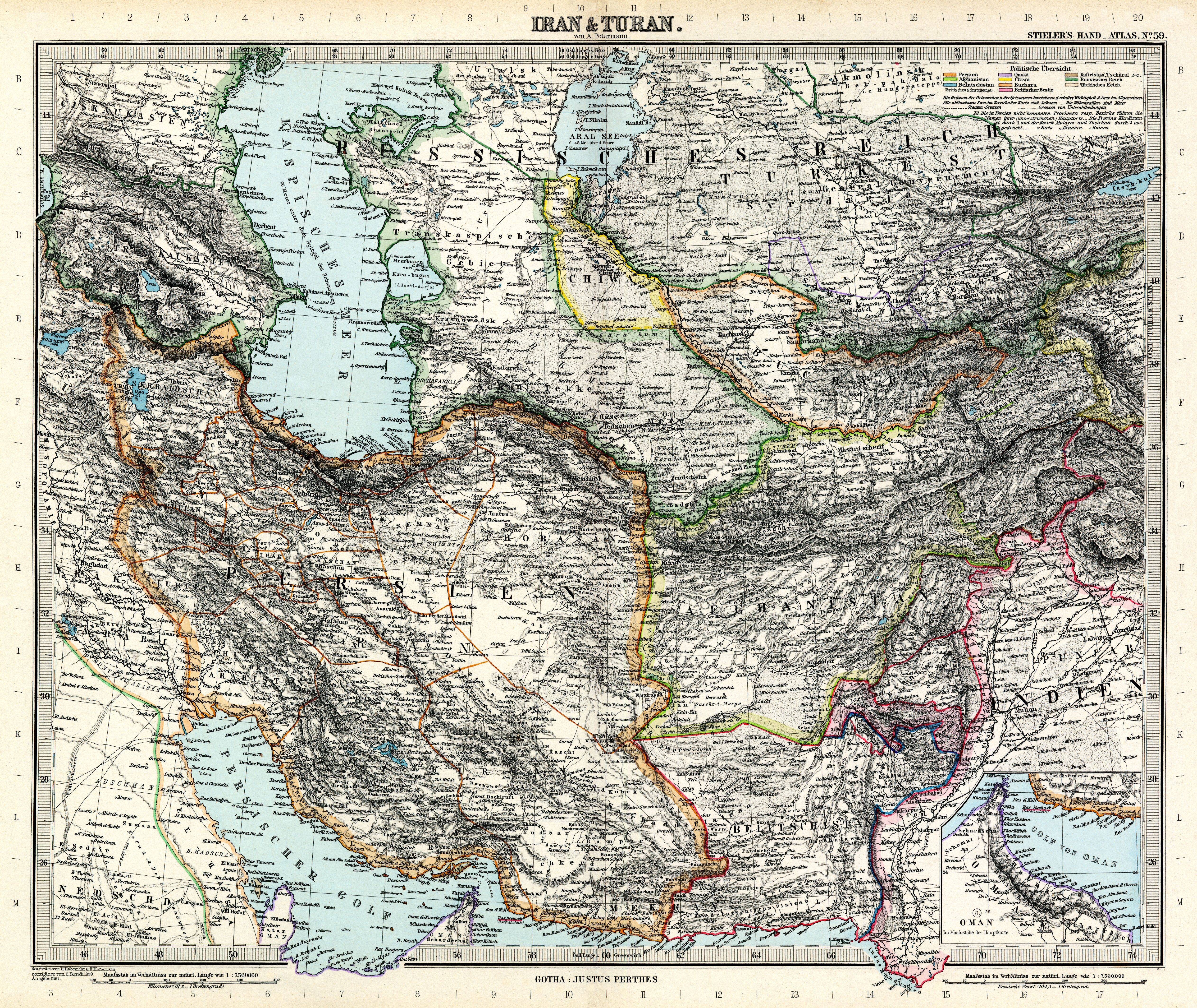
Deutsch: Iran & Turan
English: Iran & Turan |
||||||||||||||||||||||||||||||||||||||||||||||||||||||||||||||||||||||||||||||||||||||||||||||||||||||
| Datum van uitgave | 1891 | ||||||||||||||||||||||||||||||||||||||||||||||||||||||||||||||||||||||||||||||||||||||||||||||||||||||
| Bron | Adolf Stielers Handatlas | ||||||||||||||||||||||||||||||||||||||||||||||||||||||||||||||||||||||||||||||||||||||||||||||||||||||
| Toestemming (Hergebruik van dit bestand) |
|
||||||||||||||||||||||||||||||||||||||||||||||||||||||||||||||||||||||||||||||||||||||||||||||||||||||


.jpg)

Authors:
| Karl Barich
(1859–1931) |
|||
|---|---|---|---|
| Aliassen |
Karl Barich | ||
| Beschrijving | cartograaf | ||
| Geboorte- en sterfdatum |
15 april 1859 |
22 juli 1931 | |
| Geboorte- en sterfplaats | Gotha | ||
| Bibliografische informatie | |||


derivative works
Afgeleide werken van dit bestand:
- Stielers Handatlas 1891 59 Aral Sea.jpg
- Stielers Handatlas 1891 59 Caspian Sea 1.jpg
- Stielers Handatlas 1891 59 Caspian Sea.jpg
- Stielers Handatlas 1891 59 Caucasus.jpg
- Stielers Handatlas 1891 59 Georgia.jpg
- Stielers Handatlas 1891 59 Iran.jpg
|
Bestandsgeschiedenis
Klik op een datum/tijd om het bestand te zien zoals het destijds was.
| Datum/tijd | Miniatuur | Afmetingen | Gebruiker | Opmerking | |
|---|---|---|---|---|---|
| huidige versie | 13 mrt 2010 10:00 | | 5.050 × 4.250 (7,62 MB) | Kolossos | better quality |
| 13 mrt 2010 09:59 |  | 5.050 × 4.300 (6,87 MB) | Kolossos | better quality | |
| 21 nov 2006 19:43 |  | 3.788 × 3.188 (1,54 MB) | Poccil | {{Stielers Handatlas 1891|58|60|Iran & Turan|Iran & Turan}} |
Bestandsgebruik
Geen enkele pagina gebruikt dit bestand.
Globaal bestandsgebruik
De volgende andere wiki's gebruiken dit bestand:
- Gebruikt op azb.wikipedia.org
- Gebruikt op bn.wikipedia.org
- Gebruikt op bs.wikipedia.org
- Gebruikt op ckb.wikipedia.org
- Gebruikt op de.wikipedia.org
- Gebruikt op en.wikipedia.org
- Turan
- Stielers Handatlas
- Adolf Stieler
- Talk:Stielers Handatlas
- Wikipedia:Featured pictures/Diagrams, drawings, and maps/Maps
- Wikipedia:Featured pictures thumbs/53
- Wikipedia:Featured picture candidates/Stielers Handatlas 1891 59.jpg
- Wikipedia:Featured picture candidates/June-2015
- Wikipedia:Featured picture candidates/August-2015
- Wikipedia:Featured picture candidates/Stielers Handatlas 1891 59.jpg - 2nd
- Wikipedia:Wikipedia Signpost/2015-09-09/Featured content
- Wikipedia:Wikipedia Signpost/Single/2015-09-09
- User talk:Alborzagros/Archive 6
- Wikipedia:Picture of the day/May 2018
- Template:POTD/2018-05-21
- Wikipedia:Main Page history/2018 May 21
- Gebruikt op es.wikipedia.org
- Gebruikt op fa.wikipedia.org
- جغرافیای ایران
- تاریخ ایران
- توران
- بلوچستان
- تحریف نام خلیج فارس
- خرقان
- مرزهای ایران
- جغرافیای تاریخی ایران
- ویکیپدیا:نگارههای برگزیده/نقشه
- ویکیپدیا:گزیدن نگاره برگزیده/ژوئن-۲۰۱۲
- نامهای ایران
- نقشه ایران در دوره افشاریه
- نقشه جزیره هرمز، ۱۷۵۰ میلادی
- آدولف اشتیلر
- نقشه ایران و توران در دوره قاجاریه
- ویکیپدیا:گزیدن نگاره برگزیده/Stielers Handatlas 1891 59.jpg
- ویکیپدیا:نگاره روز/اکتبر ۲۰۱۲
- الگو:نر/2012-10-01
- الگو:نر محافظت شده/2012-10-01
- بحث کاربر:Alborzagros/بایگانی ۷
- نقشه خاورمیانه ساموئل آگوستوس میشل
- نقشه ایران در اواخر دوره صفویه
- الگو:نقشههای قدیمی ایران
- ویکیپدیا:نگاره روز/آوریل ۲۰۱۸
- ویکیپدیا:نگاره روز/آوریل ۲۰۲۰
- الگو:نر/2018-04-30
- الگو:نر محافظت شده/2018-04-30
Globaal gebruik van dit bestand bekijken.