
Bestand:TsunamiAftermathNorthofPhuket NASA.jpg

Grootte van deze voorvertoning: 647 × 599 pixels. Andere resoluties: 259 × 240 pixels | 518 × 480 pixels | 829 × 768 pixels | 1.106 × 1.024 pixels | 1.987 × 1.840 pixels.
Oorspronkelijk bestand (1.987 × 1.840 pixels, bestandsgrootte: 720 kB, MIME-type: image/jpeg)
| Dit is een bestand van Wikimedia Commons. Onderstaande beschrijving komt van de beschrijving van het bestand daar. |
Beschrijving
| Beschrijving |
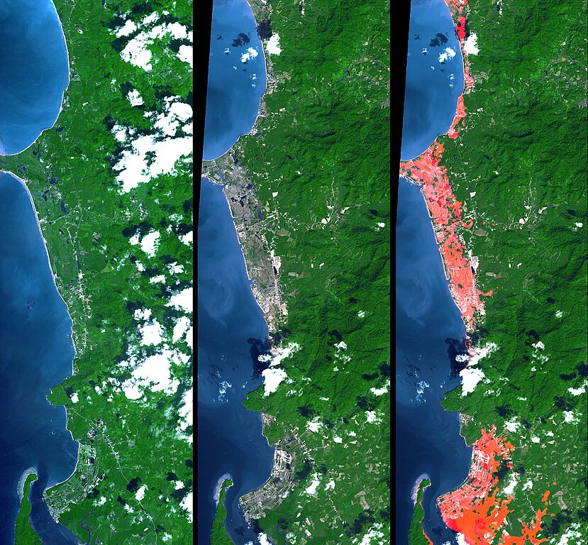
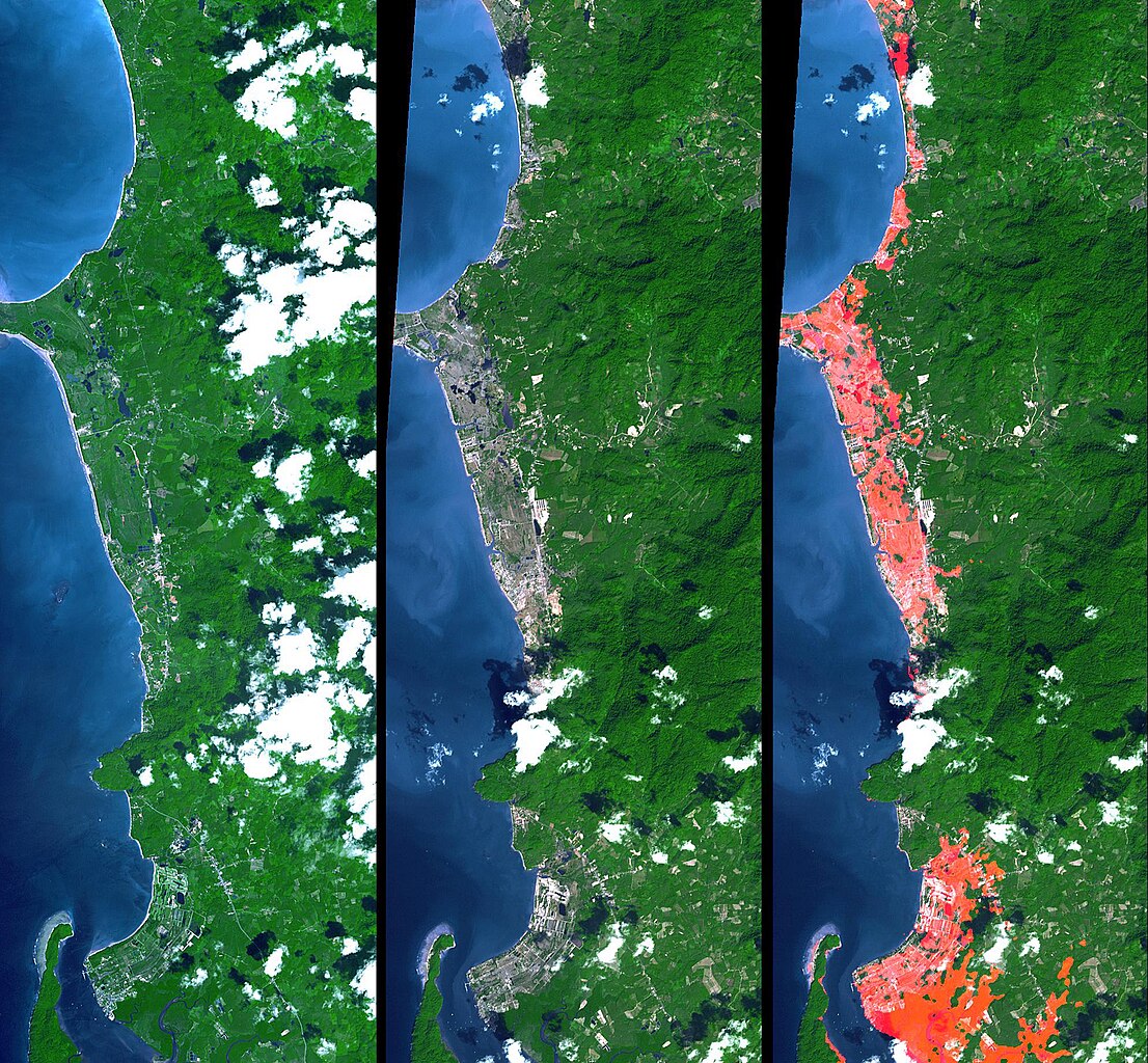
English: Simulated natural color images of a 27 kilometer long stretch of coast north of the Phuket Airport in the Khao Lak, Thailand on December 31 (middle) and two years earlier (left), showing changes to the coast caused by a tsunami. The image on the right is the image in the middle with red highlights of the changes. Additional details can be found at the source link. |
| Datum | November 15, 2002 and December 31, 2004 (ASTER), February 2000 (SRTM). See the source link for information about the individual photos |
| Bron | NASA Photojournal - http://photojournal.jpl.nasa.gov/catalog/PIA06671 |
| Auteur |
ASTER: NASA/GSFC/METI/ERSDAC/JAROS, and U.S./Japan ASTER Science Team |
Licentie
| Dit bestand bevindt zich in het publiek domein, omdat het gemaakt is door de NASA. In de reproductierichtlijnen van de NASA staat dat "NASA-materiaal niet beschermd wordt door auteursrecht, tenzij anders vermeld". | ||
 |
Waarschuwingen:
|
Oorspronkelijk uploadlogboek
De oorspronkelijke beschrijving van deze afbeelding stond hier. Alle volgende gebruikersnamen verwijzen naar en.wikipedia.
- 2005-04-16 17:22 SeanMack 1987×1840× (737390 bytes) PIA06671: Tsunami Inundation, North of Phuket, Thailand ASTER Images and SRTM Elevation Model NASA
Bestandsgeschiedenis
Klik op een datum/tijd om het bestand te zien zoals het destijds was.
| Datum/tijd | Miniatuur | Afmetingen | Gebruiker | Opmerking | |
|---|---|---|---|---|---|
| huidige versie | 2 jan 2012 03:43 | | 1.987 × 1.840 (720 kB) | File Upload Bot (Magnus Manske) | {{BotMoveToCommons|en.wikipedia|year={{subst:CURRENTYEAR}}|month={{subst:CURRENTMONTHNAME}}|day={{subst:CURRENTDAY}}}} {{Information |Description={{en|PIA06671: Tsunami Inundation, North of Phuket, Thailand ASTER Images and SRTM Elevation Model Source: |
Bestandsgebruik
Geen enkele pagina gebruikt dit bestand.
Globaal bestandsgebruik
De volgende andere wiki's gebruiken dit bestand:
- Gebruikt op de.wikipedia.org
- Gebruikt op el.wikipedia.org
- Gebruikt op en.wikipedia.org
- Gebruikt op eo.wikipedia.org
- Gebruikt op ko.wikipedia.org
- Gebruikt op ms.wikipedia.org
- Gebruikt op my.wikipedia.org
- Gebruikt op pt.wikipedia.org
- Gebruikt op tr.wikipedia.org
- Gebruikt op www.wikidata.org