
Bestand:US Court of Appeals and District Court map.svg

Afmetingen van deze voorvertoning van het type PNG van dit SVG-bestand: 620 × 402 pixels Andere resoluties: 320 × 207 pixels | 640 × 415 pixels | 1.024 × 664 pixels | 1.280 × 830 pixels | 2.560 × 1.660 pixels.
Oorspronkelijk bestand (SVG-bestand, nominaal 620 × 402 pixels, bestandsgrootte: 768 kB)
| Dit is een bestand van Wikimedia Commons. Onderstaande beschrijving komt van de beschrijving van het bestand daar. |
Beschrijving
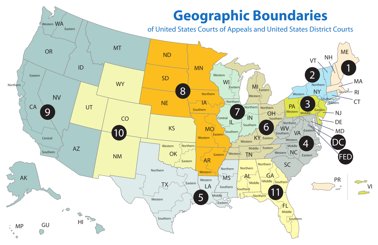
| Beschrijving | Map of the geographic boundaries of the various United States courts of appeals and United States district courts. |
| Datum | |
| Bron | http://www.uscourts.gov/uscourts/images/CircuitMap.pdf |
| Auteur | PDF by the US Government, converted using Texterity's FreeSVG, tweaked using en:Inkscape by Tintazul |
| Andere versies |
|


Licentie
This work is licensed by the creator under the following conditions:
Dit bestand is gelicenseerd onder de Creative Commons-licentie Naamsvermelding-Gelijk delen 2.5 Unported
- De gebruiker mag:
- Delen – het werk kopiëren, verspreiden en doorgeven
- Remixen – afgeleide werken maken
- Onder de volgende voorwaarden:
- naamsvermelding – U moet op een gepaste manier aan naamsvermelding doen, een link naar de licentie geven, en aangeven of er wijzigingen in het werk zijn aangebracht. U mag dit op elke redelijke manier doen, maar niet zodanig dat de indruk wordt gewekt dat de licentiegever instemt met uw werk of uw gebruik van zijn werk.
- Gelijk delen – Als u het werk heeft geremixt, veranderd, of erop heeft voortgebouwd, moet u het gewijzigde materiaal verspreiden onder dezelfde licentie als het oorspronkelijke werk, of een daarmee compatibele licentie.
The original work from which this is derived is in the public domain for the following reason:
This image is a work of a United States Department of Justice employee, taken or made as part of that person's official duties. As a work of the U.S. federal government, the image is in the public domain (17 U.S.C. § 101 and 105).
|
 |
Bestandsgeschiedenis
Klik op een datum/tijd om het bestand te zien zoals het destijds was.
| Datum/tijd | Miniatuur | Afmetingen | Gebruiker | Opmerking | |
|---|---|---|---|---|---|
| huidige versie | 17 apr 2018 20:58 | | 620 × 402 (768 kB) | BenbowInn | DC and FED are circuits too, added black circles to emphasize them, also converted to plain SVG |
| 11 jul 2006 09:48 |  | 620 × 402 (1,14 MB) | Tintazul | {{Tintazul |Description=Map of the geographic boundaries of the various United States Courts of Appeals and United States District Courts. |Source=[http://www.uscourts.gov/image |
Bestandsgebruik
Dit bestand wordt op de volgende pagina gebruikt:
Globaal bestandsgebruik
De volgende andere wiki's gebruiken dit bestand:
- Gebruikt op ar.wikipedia.org
- Gebruikt op bg.wikipedia.org
- Gebruikt op bn.wikipedia.org
- Gebruikt op ca.wikipedia.org
- Gebruikt op cs.wikipedia.org
- Gebruikt op da.wikipedia.org
- Gebruikt op de.wikipedia.org
- Gebruikt op en.wikipedia.org
- Federal jurisdiction (United States)
- United States courts of appeals
- United States district court
- United States federal judicial district
- United States Court of Appeals for the Ninth Circuit
- United States Court of Appeals for the Eighth Circuit
- Case citation
- List of regions of the United States
- United States Court of Appeals for the First Circuit
- United States Court of Appeals for the Second Circuit
- United States Court of Appeals for the Third Circuit
- United States Court of Appeals for the Fourth Circuit
- United States Court of Appeals for the Fifth Circuit
- United States Court of Appeals for the Sixth Circuit
- United States Court of Appeals for the Seventh Circuit
- United States Court of Appeals for the Tenth Circuit
- United States Court of Appeals for the Eleventh Circuit
- United States Attorney
- United States Court of Appeals for the District of Columbia Circuit
- Circuit court
- United States District Court for the Southern District of New York
- United States District Court for the Eastern District of Virginia
- United States District Court for the Eastern District of Pennsylvania
- United States District Court for the Central District of California
- List of former United States district courts
- United States District Court for the Western District of New York
- United States District Court for the Eastern District of New York
- United States District Court for the Northern District of New York
- United States District Court for the Middle District of Alabama
- United States District Court for the Southern District of Alabama
- United States District Court for the Northern District of Alabama
- United States District Court for the Southern District of California
- United States District Court for the Southern District of Florida
- United States District Court for the Northern District of California
- United States District Court for the Northern District of Oklahoma
Globaal gebruik van dit bestand bekijken.