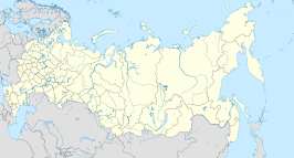
Nartkala
Uiterlijk
| Stad in Rusland | |||
|---|---|---|---|

| |||
| Nartkala | |||
| Locatie in Rusland | |||
| Kerngegevens | |||
| Autonome republiek | Kabardië-Balkarië | ||
| Coördinaten | 43° 33′ NB, 43° 51′ OL | ||
| Algemeen | |||
| Oppervlakte | 5 km² | ||
| Inwoners (volkstelling 2002) |
33.775 (6.755 inw./km²) | ||
| Hoogte centrum | 290 m | ||
| Gebeurtenissen en bestuur | |||
| Gesticht | 1913 | ||
| Stadstatus | 1955 | ||
| Eerdere namen | tot 1967: Doksjoekino | ||
| Hoofdplaats van | district Oervanski | ||
| Overig | |||
| Postcode(s) | 36133x | ||
| Netnummer(s) | (+7) 86635 | ||
| OKATO-code | 83240501 | ||
| Tijdzone | MSK (UTC+3) | ||
| |||
Nartkala (Russisch: Нарткала) is een stad in de Russische autonome republiek Kabardië-Balkarië. De stad ligt 25 km ten noordoosten van Naltsjik.
In 1913 werd Nartkala als het spoorwegstation Doksjoekino (Докшукино) gesticht. In 1955 verkreeg Doksjoekino stadsstatus. De stad werd hernoemd naar Nartkala in 1967.
| 1939 | 1959 | 1970 | 1979 | 1989 | 2002 |
|---|---|---|---|---|---|
| 5.400 | 13.100 | 19.000 | 23.400 | 28.171 | 33.775 |


