
Bestand:Map of Table Bay, Labrador.png
Grootte van deze voorvertoning: 800 × 513 pixels. Andere resoluties: 320 × 205 pixels | 640 × 411 pixels | 848 × 544 pixels.
Oorspronkelijk bestand (848 × 544 pixels, bestandsgrootte: 415 kB, MIME-type: image/png)
| Dit is een bestand van Wikimedia Commons. Onderstaande beschrijving komt van de beschrijving van het bestand daar. |
Beschrijving
| Beschrijving |
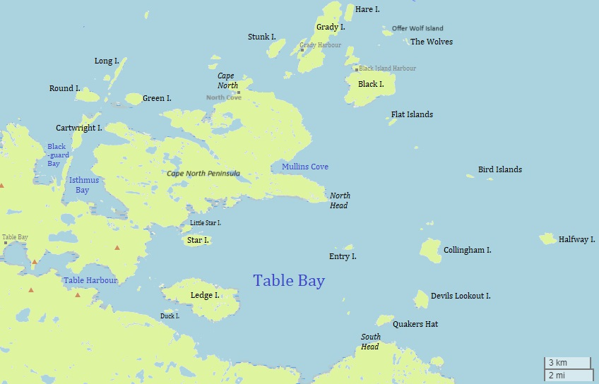
English: This is a map of Table Bay and surrounding area in Labrador, Canada. |
| Datum | |
| Bron | w:OpenStreetMap including additions by User:Ycleymans. |
| Auteur | © users of OpenStreetMap and User:Ycleymans. |
Licentie
Dit bestand is gelicenseerd onder de Creative Commons-licentie Naamsvermelding 2.5 Unported
- De gebruiker mag:
- Delen – het werk kopiëren, verspreiden en doorgeven
- Remixen – afgeleide werken maken
- Onder de volgende voorwaarden:
- naamsvermelding – U moet op een gepaste manier aan naamsvermelding doen, een link naar de licentie geven, en aangeven of er wijzigingen in het werk zijn aangebracht. U mag dit op elke redelijke manier doen, maar niet zodanig dat de indruk wordt gewekt dat de licentiegever instemt met uw werk of uw gebruik van zijn werk.
Bestandsgeschiedenis
Klik op een datum/tijd om het bestand te zien zoals het destijds was.
| Datum/tijd | Miniatuur | Afmetingen | Gebruiker | Opmerking | |
|---|---|---|---|---|---|
| huidige versie | 12 mei 2024 20:37 | | 848 × 544 (415 kB) | Ycleymans | Added Offer Wolf Island and Cape North Peninsula to the map and corrected location of North Cove |
| 15 jun 2022 22:38 |  | 848 × 544 (90 kB) | Ycleymans | Uploaded a work by © users of OpenStreetMap and User:Ycleymans. from w:OpenStreetMap including additions by User:Ycleymans. with UploadWizard |
Bestandsgebruik
Dit bestand wordt op de volgende 19 pagina's gebruikt:
- Bird Islands (Labrador)
- Black Island
- Cape North-schiereiland
- Collingham Island
- Devils Lookout Island
- Entry Island (Table Bay)
- Flat Islands (Labrador)
- Halfway Island (Newfoundland en Labrador)
- Ledge Island
- North Cove (Canada)
- Offer Wolf Island
- Quakers Hat
- South Road
- Star Island (Newfoundland en Labrador)
- Table Bay (baai in Canada)
- Table Bay (spookdorp)
- Table Harbour
- Table Hill (heuvel bij de Table Bay)
- The Wolves (Newfoundland en Labrador)
Globaal bestandsgebruik
De volgende andere wiki's gebruiken dit bestand:
- Gebruikt op en.wikipedia.org