
Bestand:Netherlands, Almelo, map of 1866.jpg
Grootte van deze voorvertoning: 706 × 600 pixels. Andere resoluties: 283 × 240 pixels | 565 × 480 pixels | 904 × 768 pixels | 1.205 × 1.024 pixels | 2.411 × 2.048 pixels | 3.296 × 2.800 pixels.
Oorspronkelijk bestand (3.296 × 2.800 pixels, bestandsgrootte: 5,59 MB, MIME-type: image/jpeg)
Dit is een bestand van Wikimedia Commons.
Onderstaande beschrijving komt van de beschrijving van het bestand daar.
Onderstaande beschrijving komt van de beschrijving van het bestand daar.
Beschrijving
| Beschrijving |
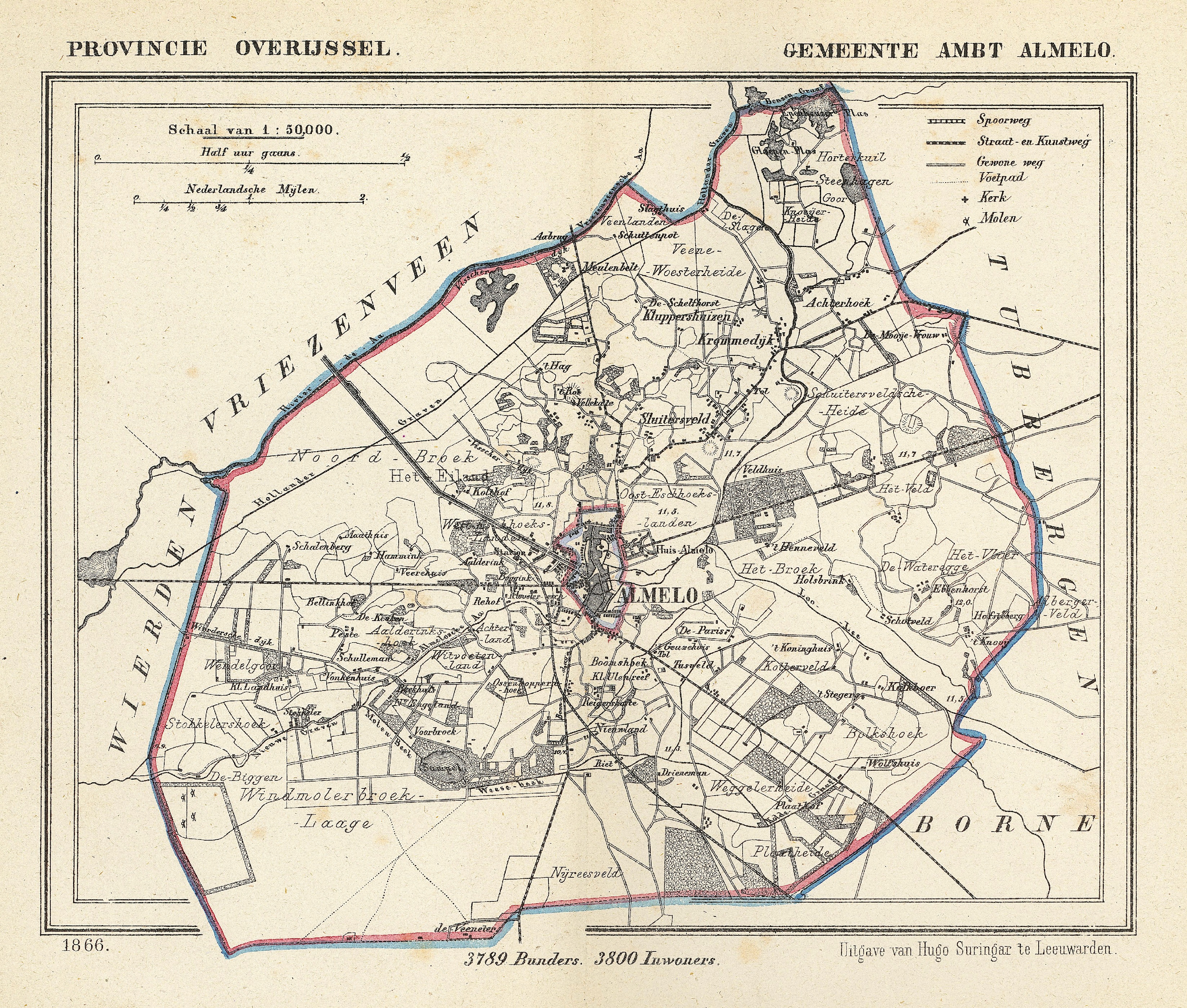
Nederlands: Tussen 1818 en 1914 was de gemeente Almelo opgesplitst in de gemeenten Stad Almelo en Ambt Almelo. Deze kaart uit 1866 toont het Ambt Almelo; de Stad Almelo ligt in het midden daarvan. Provincie Overijssel.
English: Between 1818 and 1914 the municipality of Almelo (Province Overijssel, Netherlands) was subdivided into two parts: the city itself, and the surrounding rural area called "ambt". In this map of 1866 the town of Almelo is shown as an 'island' in the centre of its "ambt". |
||||
| Datum | Published around 1870 as part of a series of provincial atlases of the Netherlands. | ||||
| Bron | Gemeente-atlas van Nederland naar officieele bronnen bewerkt. | ||||
| Auteur | J. Kuyper | ||||
| Toestemming (Hergebruik van dit bestand) |
This image is in the public domain. The author J. Kuyper died in 1908. [In the Netherlands copyright expires 70 years after the death of the author or 70 years after first publication in the case of anonymous or pseudonymous works or works published by a legal entity]. [Het auteursrecht in Nederland vervalt 70 jaar na de dood van de auteur of 70 jaar na de eerste openbaarmaking van het werk, indien het gaat om een anoniem of om een onder pseudoniem verschenen werk of werk van een rechtspersoon]. | ||||
| Andere versies |
The church in the centre of Almelo is at:
|
Licentie
|
Dit werk bevindt zich in het publiek domein in landen en gebieden waar de auteursrechttermijn het leven van de auteur plus 70 jaar of minder is. | |
| Van dit bestand is vastgesteld dat er geen bekende auteursrechtaanspraken op rusten, alle aanverwante en naburige rechten daarbij inbegrepen. | |
Bestandsgeschiedenis
Klik op een datum/tijd om het bestand te zien zoals het destijds was.
| Datum/tijd | Miniatuur | Afmetingen | Gebruiker | Opmerking | |
|---|---|---|---|---|---|
| huidige versie | 1 dec 2011 01:26 | | 3.296 × 2.800 (5,59 MB) | Loranchet | {{Information |Description ={{nl|1=Tussen 1818 en 1914 was de gemeente Almelo opgesplitst in de gemeenten Stad Almelo en Ambt Almelo. Deze kaart uit 1866 toont het Ambt Almelo; de Stad Almelo ligt in het midden daarvan. Provincie Overijssel.}} {{en|1=B |
Bestandsgebruik
Dit bestand wordt op de volgende 11 pagina's gebruikt: