
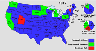
Bestand:1912 Electoral Map.png

Grootte van deze voorvertoning: 800 × 430 pixels. Andere resoluties: 320 × 172 pixels | 640 × 344 pixels | 1.182 × 635 pixels.
Oorspronkelijk bestand (1.182 × 635 pixels, bestandsgrootte: 86 kB, MIME-type: image/png)
| Dit is een bestand van Wikimedia Commons. Onderstaande beschrijving komt van de beschrijving van het bestand daar. |
| U.S. presidential election maps from the National Atlas of the United States |
| See also: SVG maps |
| 1789 · 1792 · 1796 · 1800 · 1804 · 1808 · 1812 · 1816 · 1820 · 1824 · 1828 · 1832 · 1836 · 1840 · 1844 · 1848 · 1852 · 1856 · 1860 · 1864 · 1868 · 1872 · 1876 · 1880 · 1884 · 1888 · 1892 · 1896 · 1900 · 1904 · 1908 · 1912 · 1916 · 1920 · 1924 · 1928 · 1932 · 1936 · 1940 · 1944 · 1948 · 1952 · 1956 · 1960 · 1964 · 1968 · 1972 · 1976 · 1980 · 1984 · 1988 · 1992 · 1996 · 2000 · 2004 |
Beschrijving
| Beschrijving | ||||
| Bron | https://nationalmap.gov/small_scale/printable/elections.html | |||
| Auteur | United States Geological Survey | |||
| Andere versies |
|


Licentie
This map was obtained from an edition of the National Atlas of the United States. Like almost all works of the U.S. federal government, works from the National Atlas are in the public domain in the United States.
Online access: NationalAtlas.gov | 1970 print edition: Library of Congress, Perry-Castañeda Library
|
Bestandsgeschiedenis
Klik op een datum/tijd om het bestand te zien zoals het destijds was.
| Datum/tijd | Miniatuur | Afmetingen | Gebruiker | Opmerking | |
|---|---|---|---|---|---|
| huidige versie | 12 feb 2009 03:43 | | 1.182 × 635 (86 kB) | Disposable.Heroes | pngcrush |
| 26 jun 2008 00:27 |  | 1.182 × 635 (179 kB) | Tallicfan20 | ||
| 26 mei 2008 01:35 |  | 1.182 × 635 (149 kB) | Tallicfan20 | distinguish the blue and green better, match bar under TR's face | |
| 25 mei 2008 06:50 |  | 1.182 × 635 (150 kB) | Tallicfan20 | better color | |
| 17 mei 2008 06:55 |  | 1.182 × 635 (103 kB) | Tallicfan20 | {{PD-USGov-Atlas}} |
Bestandsgebruik
Dit bestand wordt op de volgende pagina gebruikt:
Globaal bestandsgebruik
De volgende andere wiki's gebruiken dit bestand:
- Gebruikt op en.wikipedia.org
- Gebruikt op he.wikipedia.org
- Gebruikt op zh.wikipedia.org