
Bestand:Aldwych in 1900 (station location).png
Geen hogere resolutie beschikbaar.
Aldwych_in_1900_(station_location).png (409 × 295 pixels, bestandsgrootte: 284 kB, MIME-type: image/png)
| Dit is een bestand van Wikimedia Commons. Onderstaande beschrijving komt van de beschrijving van het bestand daar. |
.png)
| Beschrijving |
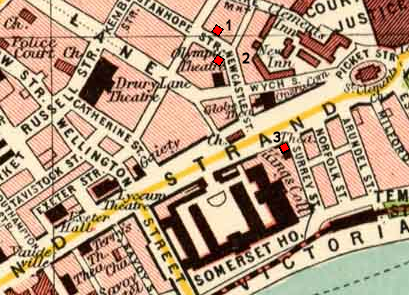
Map of Aldwych area of London circa 1900, annotated with the planned and final locations of Aldwych underground station: |
| Datum | |
| Bron |
Map taken from Plate 7 of "The Pocket Atlas & Guide to London" by John Bartholomew and Son. |
| Auteur | Base map by unknown artist, published by John Bartholomew and Son circa 1900. |
| Toestemming (Hergebruik van dit bestand) |
see below |
Dit bestand is gelicenseerd onder de Creative Commons-licentie Naamsvermelding 3.0 Unported
- De gebruiker mag:
- Delen – het werk kopiëren, verspreiden en doorgeven
- Remixen – afgeleide werken maken
- Onder de volgende voorwaarden:
- naamsvermelding – U moet op een gepaste manier aan naamsvermelding doen, een link naar de licentie geven, en aangeven of er wijzigingen in het werk zijn aangebracht. U mag dit op elke redelijke manier doen, maar niet zodanig dat de indruk wordt gewekt dat de licentiegever instemt met uw werk of uw gebruik van zijn werk.
Bestandsgeschiedenis
Klik op een datum/tijd om het bestand te zien zoals het destijds was.
| Datum/tijd | Miniatuur | Afmetingen | Gebruiker | Opmerking | |
|---|---|---|---|---|---|
| huidige versie | 26 jul 2011 17:38 | | 409 × 295 (284 kB) | McGeddon~commonswiki | scratch that - this loses the precise locations at the expense of thumbnail clarity, so probably isn't worth it |
| 26 jul 2011 17:35 |  | 409 × 295 (299 kB) | McGeddon~commonswiki | Indicating the three sites more prominently. | |
| 23 jul 2010 00:07 |  | 409 × 295 (284 kB) | DavidCane | smaller version | |
| 23 jul 2010 00:01 |  | 684 × 524 (785 kB) | DavidCane | {{Information |Description=Map of Aldwych area of London circa 1900, annotated with the planned and final locations of Aldwych underground station:<br> 1. Planned location; corner of Stanhope & Holles Street (not s |
Bestandsgebruik
Dit bestand wordt op de volgende pagina gebruikt:
Globaal bestandsgebruik
De volgende andere wiki's gebruiken dit bestand:
- Gebruikt op de.wikipedia.org
- Gebruikt op en.wikipedia.org
- Gebruikt op hu.wikipedia.org
- Gebruikt op it.wikipedia.org
- Gebruikt op zh.wikipedia.org
.png)