
Bestand:BANZSL map.png

Grootte van deze voorvertoning: 800 × 351 pixels. Andere resoluties: 320 × 140 pixels | 640 × 281 pixels | 1.425 × 625 pixels.
Oorspronkelijk bestand (1.425 × 625 pixels, bestandsgrootte: 36 kB, MIME-type: image/png)
| Dit is een bestand van Wikimedia Commons. Onderstaande beschrijving komt van de beschrijving van het bestand daar. |
| Beschrijving |
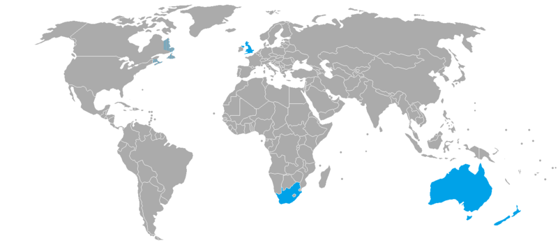
English: Countries where BANZSL is spoken. It is moribund in Canada. |
||
| Datum | kwami (talk)06:46, 15 April 2012 (UTC) | ||
| Bron | Eigen werk derived from BlankMap-World-v2.png | ||
| Auteur | Kwamikagami | ||
| Toestemming (Hergebruik van dit bestand) |
Kwamikagami op de Engelstalige Wikipedia, de auteursrechthebbende van dit werk, maakt het hierbij onder de volgende licenties beschikbaar:
Dit bestand is gelicenseerd onder de Creative Commons-licentie Naamsvermelding-Gelijk delen 3.0 Unported Naamsvermelding: Kwamikagami op de Engelstalige Wikipedia
U mag zelf één van de licenties kiezen. |


|
Deze kaartafbeelding zou opnieuw moeten worden aangemaakt als een SVG-bestand door vectorafbeeldingen te gebruiken. Dit heeft een aantal voordelen; zie Commons:Media for cleanup voor meer informatie. Als er een SVG-formaat van deze afbeelding bestaat, dan deze graag uploaden. Nadat u dit heeft gedaan, gelieve dit sjabloon te vervangen door het sjabloon {{vector version available|nieuwe bestandsnaam.svg}} op deze afbeeldingspagina.
|
Oorspronkelijk uploadlogboek
Verplaatst vanaf en.wikipedia naar Commons door ThomasPusch met behulp van CommonsHelper.
De oorspronkelijke beschrijving van deze afbeelding stond hier. Alle volgende gebruikersnamen verwijzen naar en.wikipedia.
- 2012-04-15 06:46 Kwamikagami 1425×625× (54171 bytes) Uploading a self-made file using [[Wikipedia:File_Upload_Wizard|File Upload Wizard]]
Bestandsgeschiedenis
Klik op een datum/tijd om het bestand te zien zoals het destijds was.
| Datum/tijd | Miniatuur | Afmetingen | Gebruiker | Opmerking | |
|---|---|---|---|---|---|
| huidige versie | 10 mrt 2022 13:28 | | 1.425 × 625 (36 kB) | Piperium | Fixed another SVG error on east coast of africa |
| 10 mrt 2022 13:25 |  | 1.425 × 625 (36 kB) | Piperium | Removed erroneous lines resultant of SVG errors. | |
| 18 jul 2020 08:53 |  | 1.425 × 625 (36 kB) | Maphobbyist | South Sudan border | |
| 9 jan 2013 22:58 |  | 1.425 × 625 (53 kB) | File Upload Bot (Magnus Manske) | Transfered from en.wikipedia by User:ThomasPusch using CommonsHelper |
Bestandsgebruik
Dit bestand wordt op de volgende pagina gebruikt:
Globaal bestandsgebruik
De volgende andere wiki's gebruiken dit bestand:
- Gebruikt op ca.wikipedia.org
- Gebruikt op en.wikipedia.org
- Gebruikt op eo.wikipedia.org
- Gebruikt op es.wikipedia.org
- Gebruikt op fa.wikipedia.org
- Gebruikt op fr.wikipedia.org
- Gebruikt op id.wikipedia.org
- Gebruikt op it.wikipedia.org
- Gebruikt op ja.wikipedia.org
- Gebruikt op ru.wikipedia.org
- Gebruikt op zh.wikipedia.org