Naar inhoud springen

Bestand:China map.png

Pagina-inhoud wordt niet ondersteund in andere talen.
Uit Wikipedia, de vrije encyclopedie

Oorspronkelijk bestand(705 × 705 pixels, bestandsgrootte: 135 kB, MIME-type: image/png)


Beschrijving

Bestand:China map.svg is een vectorversie van dit bestand. Indien niet van slechtere kwaliteit dient deze gebruikt te worden in plaats van deze rasterafbeelding.

File:China map.png → File:China map.svg

Zie Help:SVG voor meer informatie.

In andere talen
Alemannisch  Bahasa Indonesia  Bahasa Melayu  British English  català  čeština  dansk  Deutsch  eesti  English  español  Esperanto  euskara  français  Frysk  galego  hrvatski  Ido  italiano  lietuvių  magyar  Nederlands  norsk bokmål  norsk nynorsk  occitan  Plattdüütsch  polski  português  português do Brasil  română  Scots  sicilianu  slovenčina  slovenščina  suomi  svenska  Tiếng Việt  Türkçe  vèneto  Ελληνικά  беларуская (тарашкевіца)  български  македонски  нохчийн  русский  српски / srpski  татарча/tatarça  українська  ქართული  հայերեն  বাংলা  தமிழ்  മലയാളം  ไทย  한국어  日本語  简体中文  繁體中文  עברית  العربية  فارسی  +/−
SVG-bestand

Beschrijving
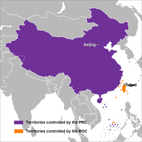
English: This is a map of the two states that officially use the name "China" in their names and depicts the actual "line of control" and not any claims that states often make. Key words: actual administration and actual maintaining of control of the territories.
中文(简体):这是一个关于两个都把“中华”用在自己的国名里的国家的地图,这个地图描绘了两国的实际“控制线”并跟两国通常声称的完全不是一回事。关键词:实际管辖和维持实际控制区域。
中文(繁體):這是一個關於兩個都把“中華”用在自己的國名裡的國家的地圖,這個地圖描繪了兩國的實際“控制線”並跟兩國通常聲稱的完全不是一回事。關鍵字:實際管轄和維持實際控制區域。
Datum 24 september 2007 (originele uploaddatum)
Bron Verplaatst vanaf en.wikipedia naar Commons door Sreejithk2000 met behulp van CommonsHelper.
Auteur Nat op de Engelstalige Wikipedia

Licentie

Nat op de Engelstalige Wikipedia, de auteursrechthebbende van dit werk, maakt het hierbij onder de volgende licenties beschikbaar:
GNU head Toestemming wordt verleend voor het kopiëren, verspreiden en/of wijzigen van dit document onder de voorwaarden van de GNU-licentie voor vrije documentatie, versie 1.2 of enige latere versie als gepubliceerd door de Free Software Foundation; zonder Invariant Sections, zonder Front-Cover Texts, en zonder Back-Cover Texts. Een kopie van de licentie is opgenomen in de sectie GNU-licentie voor vrije documentatie.
w:nl:Creative Commons
naamsvermelding
Dit bestand is gelicenseerd onder de Creative Commons-licentie Naamsvermelding 3.0 Unported
Naamsvermelding: Nat op de Engelstalige Wikipedia
De gebruiker mag:
  • Delen – het werk kopiëren, verspreiden en doorgeven
  • Remixen – afgeleide werken maken
Onder de volgende voorwaarden:
  • naamsvermelding – U moet op een gepaste manier aan naamsvermelding doen, een link naar de licentie geven, en aangeven of er wijzigingen in het werk zijn aangebracht. U mag dit op elke redelijke manier doen, maar niet zodanig dat de indruk wordt gewekt dat de licentiegever instemt met uw werk of uw gebruik van zijn werk.
U mag zelf één van de licenties kiezen.

Oorspronkelijk uploadlogboek

De oorspronkelijke beschrijving van deze afbeelding stond hier. Alle volgende gebruikersnamen verwijzen naar en.wikipedia.
  • 2008-05-29 22:44 Shibo77 705×705× (136871 bytes)
  • 2008-05-29 21:59 Shibo77 705×705× (135686 bytes)
  • 2008-05-29 21:53 Shibo77 705×705× (132630 bytes) Reverted to version as of 00:46, 16 May 2008
  • 2008-05-29 08:51 Sontung007 556×537× (31782 bytes) Reverted to the neutral version to avoid disputes and ambiguity
  • 2008-05-16 00:46 Taktser 705×705× (132630 bytes)
  • 2008-05-16 00:44 Taktser 705×705× (132710 bytes)
  • 2008-05-03 20:22 T-1000 705×705× (115888 bytes) Reverted to version as of 22:31, 4 April 2008
  • 2008-04-08 17:10 Heavyrain2408 705×705× (129360 bytes) Chinese people use tricky word "administration" to mislead readers to believe these islands belonging to them. Please stop these kinds of actions.
  • 2008-04-04 22:31 Taktser 705×705× (115888 bytes) Reverted to version as of 20:02, 27 March 2008 (administration is clearly stated, not the question of sovereignty over these territories, Arunachal Pradesh is excluded; Aksai Chin, the Spratly islands and some of the Paracel islands are included)
  • 2008-03-30 05:36 Heavyrain2408 705×705× (129360 bytes) Constroversary parts should not be included. This could result readers think that these parts belong to China.
  • 2008-03-27 20:02 Taktser 705×705× (115888 bytes) Reverted to version as of 20:31, 10 March 2008 It's clearly stated as administration not sovereignty
  • 2008-03-21 21:11 Sontung007 705×705× (129360 bytes) the previous map wrongly included unresolved disputed islands
  • 2008-03-10 20:31 Taktser 705×705× (115888 bytes) Reverted to version as of 16:33, 16 November 2007
  • 2008-01-24 15:26 Sinoevils 705×705× (129360 bytes) This is the real China Map
  • 2008-01-24 15:24 Sinoevils 705×705× (129360 bytes) This is the real China Map
  • 2007-11-16 16:33 Nat 705×705× (115888 bytes)
  • 2007-11-06 18:53 Nat 556×537× (30702 bytes)
  • 2007-11-05 22:48 Nat 556×537× (33377 bytes)
  • 2007-10-28 07:25 Jjhcap99 556×537× (31782 bytes) Added country names.
  • 2007-10-19 22:35 Jerrch 556×537× (30043 bytes) Capitalized the capitals
  • 2007-10-16 22:23 Nat 556×537× (30403 bytes) Reverted to version as of 19:37, 9 October 2007
  • 2007-10-16 20:34 Jerrch 556×537× (30411 bytes) Reverted to version as of 19:56, 29 September 2007
  • 2007-10-15 13:05 Jjhcap99 556×537× (33989 bytes)
  • 2007-10-09 19:37 Nat 556×537× (30403 bytes) This is the work of {{user|Nat}}
  • 2007-10-09 19:32 Nat 556×537× (32238 bytes) This is the work of {{User7|Nat}}.
  • 2007-09-29 19:56 Jerrch 556×537× (30411 bytes) changed color a little bit to make it just a little more neutral.
  • 2007-09-24 23:16 Nat 556×537× (30343 bytes)
  • 2007-09-24 01:44 Nat 1127×1069× (958918 bytes)
Aantekeningen
InfoField
Deze afbeelding is aangetekend: Bekijk de aantekeningen op Commons

Bijschriften

Beschrijf in één regel wat dit bestand voorstelt

Items getoond in dit bestand

beeldt af

image/png

a3914e0e367e3234152db8229f8c9413a6fc7c3e

138.578 byte

705 pixel

705 pixel

Bestandsgeschiedenis

Klik op een datum/tijd om het bestand te zien zoals het destijds was.

Datum/tijdMiniatuurAfmetingenGebruikerOpmerking
huidige versie15 dec 2014 08:14Miniatuurafbeelding voor de versie van 15 dec 2014 08:14705 × 705 (135 kB)Shibo77..
2 jun 2010 12:26Miniatuurafbeelding voor de versie van 2 jun 2010 12:26705 × 705 (134 kB)File Upload Bot (Magnus Manske) {{BotMoveToCommons|en.wikipedia|year={{subst:CURRENTYEAR}}|month={{subst:CURRENTMONTHNAME}}|day={{subst:CURRENTDAY}}}} {{Information |Description={{en|This is a map of the two states that officially use the name "China" in their names and depicts the act

Dit bestand wordt op de volgende pagina gebruikt:

Globaal bestandsgebruik

De volgende andere wiki's gebruiken dit bestand:

Globaal gebruik van dit bestand bekijken.

Metadata