
Bestand:EnglandCheshireEast.png
Geen hogere resolutie beschikbaar.
EnglandCheshireEast.png (200 × 247 pixels, bestandsgrootte: 25 kB, MIME-type: image/png)
| Dit is een bestand van Wikimedia Commons. Onderstaande beschrijving komt van de beschrijving van het bestand daar. |
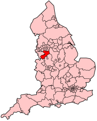
| Beschrijving | Map showing location of Cheshire East Unitary Authority (effective 1st April 2009) in England. |
| Datum | |
| Bron | Own work, derived from File:BlankMap-EnglandSubdivisions2009.png. |
| Auteur | Keith Edkins |
Licentie
| Dit bestand is gelicenseerd onder de Creative Commons-licentie Naamsvermelding-Gelijk delen 3.0 Unported Onderhevig aan disclaimers. | ||
| ||
| Deze licentietag is toegevoegd aan dit bestand in verband met de GFDL licentie-update. |

|
Toestemming wordt verleend voor het kopiëren, verspreiden en/of wijzigen van dit document onder de voorwaarden van de GNU-licentie voor vrije documentatie, versie 1.2 of enige latere versie als gepubliceerd door de Free Software Foundation; zonder Invariant Sections, zonder Front-Cover Texts, en zonder Back-Cover Texts. Een kopie van de licentie is opgenomen in de sectie GNU-licentie voor vrije documentatie. Onderhevig aan disclaimers. |
Bestandsgeschiedenis
Klik op een datum/tijd om het bestand te zien zoals het destijds was.
| Datum/tijd | Miniatuur | Afmetingen | Gebruiker | Opmerking | |
|---|---|---|---|---|---|
| huidige versie | 12 mrt 2009 11:39 | | 200 × 247 (25 kB) | Keith Edkins | {{Information |Description=Map showing location of Cheshire East Unitary Authority (effective 1st April 2009) in England. |Source=Own work, derived from File:BlankMap-EnglandSubdivisions2009.png. |Date=12 March 2009 |Author=[[User:Keith Edkins|Keith |
Bestandsgebruik
Dit bestand wordt op de volgende pagina gebruikt:
Globaal bestandsgebruik
De volgende andere wiki's gebruiken dit bestand:
- Gebruikt op ar.wikipedia.org
- Gebruikt op ceb.wikipedia.org
- Gebruikt op fr.wikipedia.org
- Gebruikt op sv.wikipedia.org
- Gebruikt op uk.wikipedia.org
- Gebruikt op www.wikidata.org
- Gebruikt op zh-min-nan.wikipedia.org