
Bestand:FalklandEconomicZone.png
Grootte van deze voorvertoning: 799 × 600 pixels. Andere resoluties: 320 × 240 pixels | 640 × 480 pixels | 938 × 704 pixels.
Oorspronkelijk bestand (938 × 704 pixels, bestandsgrootte: 807 kB, MIME-type: image/png)
| Dit is een bestand van Wikimedia Commons. Onderstaande beschrijving komt van de beschrijving van het bestand daar. |
Beschrijving
| Beschrijving |
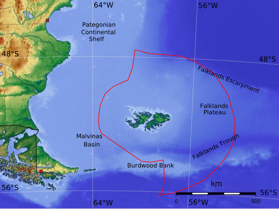
English: Map of the Falkland Islands maritime economic zone |
| Datum | |
| Bron | Eigen werk |
| Auteur | Martinvl |
This work used [Argentine_Topo_blank.jpg] as a start point.
Licentie
Ik, de auteursrechthebbende van dit werk, maak het hierbij onder de volgende licentie beschikbaar:
Dit bestand is gelicenseerd onder de Creative Commons-licentie Naamsvermelding 3.0 Unported
- De gebruiker mag:
- Delen – het werk kopiëren, verspreiden en doorgeven
- Remixen – afgeleide werken maken
- Onder de volgende voorwaarden:
- naamsvermelding – U moet op een gepaste manier aan naamsvermelding doen, een link naar de licentie geven, en aangeven of er wijzigingen in het werk zijn aangebracht. U mag dit op elke redelijke manier doen, maar niet zodanig dat de indruk wordt gewekt dat de licentiegever instemt met uw werk of uw gebruik van zijn werk.
Bestandsgeschiedenis
Klik op een datum/tijd om het bestand te zien zoals het destijds was.
| Datum/tijd | Miniatuur | Afmetingen | Gebruiker | Opmerking | |
|---|---|---|---|---|---|
| huidige versie | 2 apr 2016 14:12 | | 938 × 704 (807 kB) | Martinvl | "Burnwood" => "Burdwood" (correct file this time I hope!) |
| 2 apr 2016 14:10 |  | 938 × 704 (807 kB) | Martinvl | "Burnwood" => "Burdwood" | |
| 29 jun 2010 22:19 |  | 938 × 704 (736 kB) | Martinvl | {{Information |Description={{en|1=Map of the Falkland Islands maritime economic zone}} |Source={{own}} |Author=Martinvl |Date=2010-06-29 |Permission= |other_versions= }} This work used [Argentine_Topo_blank.jpg] as a start point. |
Bestandsgebruik
Dit bestand wordt op de volgende pagina gebruikt:
Globaal bestandsgebruik
De volgende andere wiki's gebruiken dit bestand:
- Gebruikt op en.wikipedia.org
- Gebruikt op es.wikipedia.org
- Gebruikt op ja.wikipedia.org
- Gebruikt op ru.wikipedia.org
- Gebruikt op uk.wikipedia.org