
Bestand:Isle of Man A3 road (OpenStreetMap).png
Geen hogere resolutie beschikbaar.
Isle_of_Man_A3_road_(OpenStreetMap).png (436 × 491 pixels, bestandsgrootte: 72 kB, MIME-type: image/png)
| Dit is een bestand van Wikimedia Commons. Onderstaande beschrijving komt van de beschrijving van het bestand daar. |
.png)

|
Deze kaartafbeelding zou opnieuw moeten worden aangemaakt als een SVG-bestand door vectorafbeeldingen te gebruiken. Dit heeft een aantal voordelen; zie Commons:Media for cleanup voor meer informatie. Als er een SVG-formaat van deze afbeelding bestaat, dan deze graag uploaden. Nadat u dit heeft gedaan, gelieve dit sjabloon te vervangen door het sjabloon {{vector version available|nieuwe bestandsnaam.svg}} op deze afbeeldingspagina.
|
| Beschrijving |
Deze kaart is gemaakt op basis van OpenStreetMap projectgegevens, verzameld door de gemeenschap. Deze kaart kan onvolledig zijn en fouten bevatten. Vertrouw er niet op voor navigatie. |
| Datum | (geschiedenis bestand) |
| Bron | U kunt een pagina vinden op de OpenStreetMap pagina voor Isle of Man |
| Maker |
OpenStreetMap bijdragers |
| Toestemming (Hergebruik van dit bestand) |
OpenStreetMap-gegevens en -kaarten zijn gelicentieerd onder de Creative Commons Attribution-ShareAlike 2.0-licentie (CC-BY-SA 2.0). Dit bestand is gelicenseerd onder de Creative Commons-licentie Naamsvermelding-Gelijk delen 2.0 Unported
|
| Georeferencing | If inappropriate please set warp_status = skip to hide. |
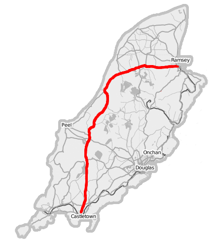
Overview map of the Isle of Man from OpenStreetMap project with the A3 Castletown to Ramsey road highlighted.
Source: Open Street Map of the Isle of Man
Bestandsgeschiedenis
Klik op een datum/tijd om het bestand te zien zoals het destijds was.
| Datum/tijd | Miniatuur | Afmetingen | Gebruiker | Opmerking | |
|---|---|---|---|---|---|
| huidige versie | 10 mei 2007 00:01 | | 436 × 491 (72 kB) | Dankarran | {{openstreetmap|name=Isle of Man}} Overview map of the Isle of Man from OpenStreetMap project with the A3 Castletown to Ramsey road highlighted. {{CC-BY-SA 2.0}} Source: [http://www.openstreetmap.org/index.html?lat=54.22907&lon=-4.44500&zoom=10 Ope |
| 9 mei 2007 23:58 |  | 436 × 491 (71 kB) | Dankarran | {{openstreetmap|name=Isle of Man}} Overview map of the Isle of Man from OpenStreetMap project with the A3 Castletown to Ramsey road highlighted. {{CC-BY-SA 2.0}} Source: [http://www.openstreetmap.org/index.html?lat=54.22907&lon=-4.44500&zoom=10 Ope |
Bestandsgebruik
Dit bestand wordt op de volgende 2 pagina's gebruikt:
Globaal bestandsgebruik
De volgende andere wiki's gebruiken dit bestand:
- Gebruikt op en.wikipedia.org
- Gebruikt op gv.wikipedia.org
- Gebruikt op www.wikidata.org
.png)