
Bestand:Map Staten Island Railway en.png
Grootte van deze voorvertoning: 651 × 600 pixels. Andere resoluties: 260 × 240 pixels | 521 × 480 pixels | 833 × 768 pixels | 1.111 × 1.024 pixels | 1.885 × 1.737 pixels.
Oorspronkelijk bestand (1.885 × 1.737 pixels, bestandsgrootte: 2,4 MB, MIME-type: image/png)
| Dit is een bestand van Wikimedia Commons. Onderstaande beschrijving komt van de beschrijving van het bestand daar. |
| Beschrijving |
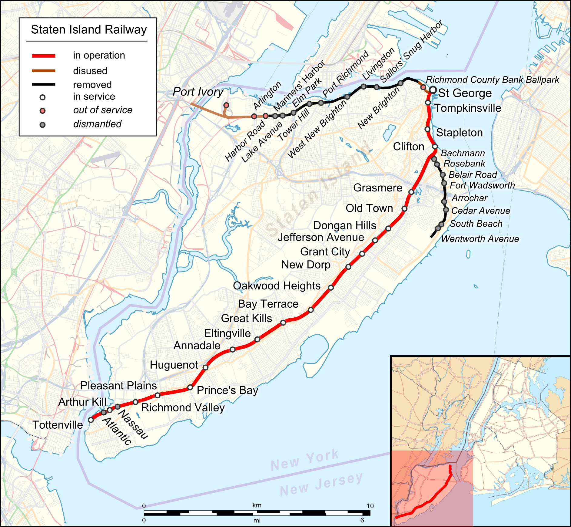
English: Location map of Staten Island Railway. English Index |
|||||||||
| Datum | ||||||||||
| Bron |
|
|||||||||
| Maker |
|
|||||||||
| Geotemporal data | ||||||||||
| Bounding box |
|
|||||||||
| Georeferencing | ||||||||||
| Andere versies |
 |
|||||||||
Ik, de auteursrechthebbende van dit werk, maak het hierbij onder de volgende licentie beschikbaar:
Dit bestand is gelicenseerd onder de Creative Commons-licentie Naamsvermelding 3.0 Unported
- De gebruiker mag:
- Delen – het werk kopiëren, verspreiden en doorgeven
- Remixen – afgeleide werken maken
- Onder de volgende voorwaarden:
- naamsvermelding – U moet op een gepaste manier aan naamsvermelding doen, een link naar de licentie geven, en aangeven of er wijzigingen in het werk zijn aangebracht. U mag dit op elke redelijke manier doen, maar niet zodanig dat de indruk wordt gewekt dat de licentiegever instemt met uw werk of uw gebruik van zijn werk.
| Dit werk is gelicenseerd onder de Open Database Licentie (samenvatting). |
Bestandsgeschiedenis
Klik op een datum/tijd om het bestand te zien zoals het destijds was.
| Datum/tijd | Miniatuur | Afmetingen | Gebruiker | Opmerking | |
|---|---|---|---|---|---|
| huidige versie | 17 aug 2023 21:22 | | 1.885 × 1.737 (2,4 MB) | DinoSoupCanada | Connected into NJ |
| 29 apr 2018 04:11 |  | 1.885 × 1.737 (2,25 MB) | Pechristener | korr: Atlantic and Nassau stops were demolished | |
| 29 apr 2018 03:55 |  | 1.885 × 1.737 (2,25 MB) | Pechristener | typos / Arthur Kill station | |
| 22 nov 2016 10:09 |  | 1.885 × 1.737 (1,57 MB) | Kopiersperre | optipng | |
| 22 nov 2016 05:41 |  | 1.885 × 1.737 (2,27 MB) | Pechristener | {{Map |Description={{en|1=Location map of {{w|Staten Island Railway}}. English Index}} |Source= * [http://www.openstreetmap.org/ Open Street Map] Data * {{f|USA_New_York_City_location_map.svg}} (for location map) |Author= * rendering with Maperitive,... |
Bestandsgebruik
Dit bestand wordt op de volgende pagina gebruikt:
Globaal bestandsgebruik
De volgende andere wiki's gebruiken dit bestand:
- Gebruikt op de.wikipedia.org
- Gebruikt op en.wikipedia.org
- Gebruikt op eo.wikipedia.org
- Gebruikt op ja.wikipedia.org
- Gebruikt op uz.wikipedia.org