
Bestand:Reichskanzlei-Vorbunker.png

Oorspronkelijk bestand (1.607 × 3.514 pixels, bestandsgrootte: 356 kB, MIME-type: image/png)
| Dit is een bestand van Wikimedia Commons. Onderstaande beschrijving komt van de beschrijving van het bestand daar. |
| Beschrijving |
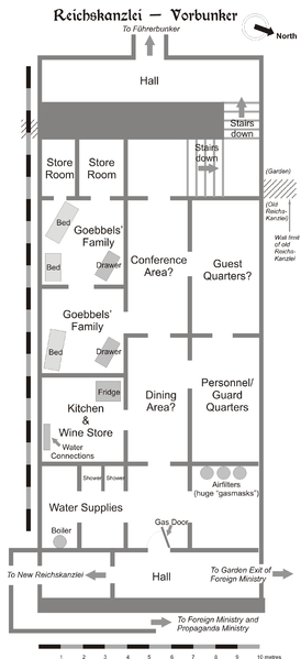
Map of the Vorbunker in Berlin, 1945. |
| Datum | |
| Bron | Eigen werk |
| Auteur | User:Dna-Dennis |
| Toestemming (Hergebruik van dit bestand) |
CC, see below. The map is completely unrestricted for any Wikipedia/Wikimedia project. |
Licentie
- De gebruiker mag:
- Delen – het werk kopiëren, verspreiden en doorgeven
- Remixen – afgeleide werken maken
- Onder de volgende voorwaarden:
- naamsvermelding – U moet op een gepaste manier aan naamsvermelding doen, een link naar de licentie geven, en aangeven of er wijzigingen in het werk zijn aangebracht. U mag dit op elke redelijke manier doen, maar niet zodanig dat de indruk wordt gewekt dat de licentiegever instemt met uw werk of uw gebruik van zijn werk.
Beschrijving
This is a map of the Vorbunker in Berlin, 1945 - the "antechamber" bunker of the famous Fuehrerbunker. The layout is not necessarily perfectly exact, but it is very probable. There were two bunkers which were connected - the Fuehrerbunker and the Vorbunker, and here is the link to my map of the Fuehrerbunker, and a link to my map showing the locations of the Fuehrerbunker and Vorbunker in Berlin, 1945.
Information about the details of the bunkers is rather scarce, which is not strange, since the bunkers were secret. This map is based on the excellent research of Tom Posch (see below), who visited and photographed the remains from inside in 1988. He concluded that the map of the bunker in Cornelius Ryan's The Last Battle was incorrect, and a new, hand-drawn map of the Vorbunker was produced by Tom Posch.
Location notes
The Fuehrerbunker, built in 1944, was located 8-17 meters beneath the Reichskanzlei garden, approx. 120 meters north of the new Reichskanzlei building, which had the address Vossstrasse 6. The Führerbunker was located somewhat lower than the Vorbunker and west (or rather west-west-south) of it. The two bunkers were connected via sets of stairs set at right angles (not spiral).
Layout notes
- Particularly uncertain items are marked with question marks.
- The exact position of water & ventilation facilites and showers are uncertain.
Construction data (approximates)
- Material: Concrete
- Protective Wall Width: 220 cm
- Protective Roof Height: 280 cm
- Wall Width (interior): 15-20 cm
- Door Heights: 180-200 cm
- Door Widths: 120 cm
- Room Heights: 2-3 m
- Room Sizes: Varying; 3-5 m
References
The map is based on the following sources:
- Ramsey, Winston G. (editor) & Posch, Tom (researcher), The Berlin Führerbunker: The Thirteenth Hole, After the Battle archief kopie op de Wayback Machine, No.61, Special Edition, Battle of Britain International Ltd, 1988, London
- Allied Intelligence Map of Key Buildings in Berlin (3rd edition, 1945)
- Ryan, Cornelius, The Last Battle (1966)
Regards,
Dennis Nilsson, Sweden.
If you wish to contact me, please leave a message on my talk page.

|
Deze architectuurafbeelding zou opnieuw moeten worden aangemaakt als een SVG-bestand door vectorafbeeldingen te gebruiken. Dit heeft een aantal voordelen; zie Commons:Media for cleanup voor meer informatie. Als er een SVG-formaat van deze afbeelding bestaat, dan deze graag uploaden. Nadat u dit heeft gedaan, gelieve dit sjabloon te vervangen door het sjabloon {{vector version available|nieuwe bestandsnaam.svg}} op deze afbeeldingspagina.
|
Bestandsgeschiedenis
Klik op een datum/tijd om het bestand te zien zoals het destijds was.
| Datum/tijd | Miniatuur | Afmetingen | Gebruiker | Opmerking | |
|---|---|---|---|---|---|
| huidige versie | 9 feb 2007 15:49 | | 1.607 × 3.514 (356 kB) | Dcoetzee | Remove license info and detailed description; these belong in the image description page or article; pngcrushed |
| 30 jan 2006 01:02 |  | 2.356 × 3.441 (757 kB) | Dna-webmaster~commonswiki | ||
| 30 jan 2006 00:27 |  | 2.357 × 3.441 (696 kB) | Dna-webmaster~commonswiki | == Licensing == {{self|cc-by-sa-2.5}} I hereby release this image with the following declaration: <i>Reproduction and distribution is allowed and encouraged as long as the author is acknowledged by name when this image is used.</i> == Description == T |
Bestandsgebruik
Dit bestand wordt op de volgende pagina gebruikt:
Globaal bestandsgebruik
De volgende andere wiki's gebruiken dit bestand:
- Gebruikt op ar.wikipedia.org
- Gebruikt op br.wikipedia.org
- Gebruikt op da.wikipedia.org
- Gebruikt op el.wikipedia.org
- Gebruikt op en.wikipedia.org
- Gebruikt op es.wikipedia.org
- Gebruikt op he.wikipedia.org
- Gebruikt op id.wikipedia.org
- Gebruikt op it.wikipedia.org
- Gebruikt op ja.wikipedia.org
- Gebruikt op ms.wikipedia.org
- Gebruikt op no.wikipedia.org
- Gebruikt op pt.wikipedia.org
- Gebruikt op ru.wikipedia.org
- Gebruikt op sv.wikipedia.org
- Gebruikt op tr.wikipedia.org
- Gebruikt op www.wikidata.org