
Bestand:Samaritan communities map.png
Geen hogere resolutie beschikbaar.
Samaritan_communities_map.png (500 × 333 pixels, bestandsgrootte: 16 kB, MIME-type: image/png)
| Dit is een bestand van Wikimedia Commons. Onderstaande beschrijving komt van de beschrijving van het bestand daar. |
Beschrijving
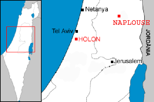
| Beschrijving | Localization of the two samaritan communities : Holon in Israel, and Nablus in the west bank. |
| Datum | |
| Bron | Image:Localització de Holon.png |
| Auteur | modified by Christophe cagé 09:54, 4 January 2007 (UTC) |
| Toestemming (Hergebruik van dit bestand) |
see license (Public domain) of original image |
| Andere versies | Image:Localització de Holon.png |
Licentie
| |
Dit bestand is door Rf op Wikimedia Commons, in het publieke domein geplaatst. Dit is wereldwijd van toepassing. In sommige landen is dit niet mogelijk; in die gevallen geldt: |
Bestandsgeschiedenis
Klik op een datum/tijd om het bestand te zien zoals het destijds was.
| Datum/tijd | Miniatuur | Afmetingen | Gebruiker | Opmerking | |
|---|---|---|---|---|---|
| huidige versie | 4 jan 2007 11:54 | | 500 × 333 (16 kB) | Christophe cagé | {{Information |Description=Localization of the two samaritan communities : Holon in Israel, and Nablus in the west bank. |Source=Image:Localització de Holon.png |Date=~~~~ |Author=modified by ~~~~ |Permission=see license (Public domain) of original |
Bestandsgebruik
Dit bestand wordt op de volgende 5 pagina's gebruikt:
Globaal bestandsgebruik
De volgende andere wiki's gebruiken dit bestand:
- Gebruikt op af.wikipedia.org
- Gebruikt op fr.wikipedia.org
- Gebruikt op it.wikipedia.org
- Gebruikt op pt.wikipedia.org