
Bestand:Tectonic map Europe.jpg
Grootte van deze voorvertoning: 505 × 599 pixels. Andere resoluties: 202 × 240 pixels | 404 × 480 pixels | 647 × 768 pixels | 1.270 × 1.507 pixels.
Oorspronkelijk bestand (1.270 × 1.507 pixels, bestandsgrootte: 757 kB, MIME-type: image/jpeg)
| Dit is een bestand van Wikimedia Commons. Onderstaande beschrijving komt van de beschrijving van het bestand daar. |
Beschrijving
| Beschrijving |
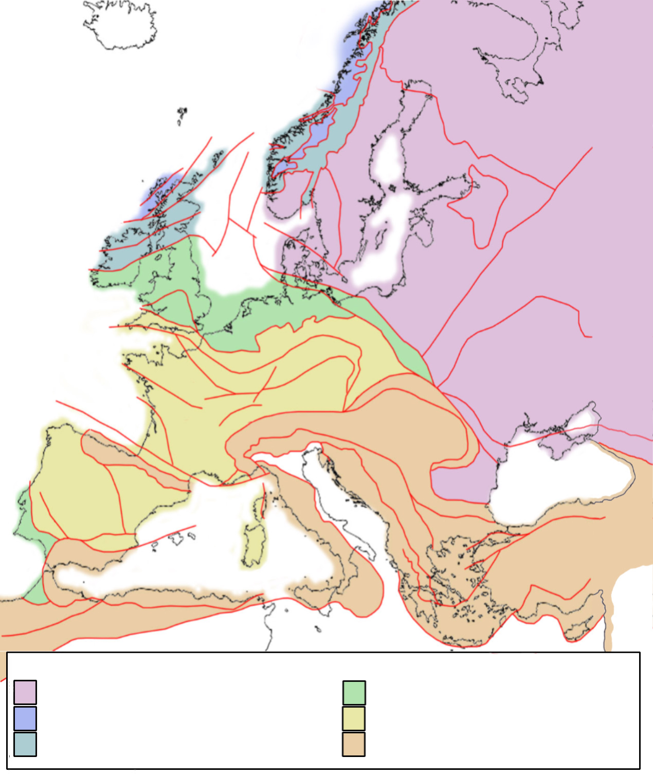
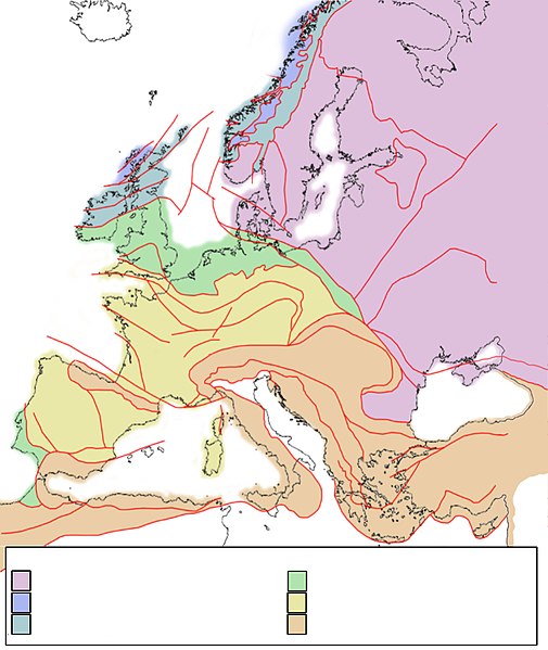
English: Tectonic framework map of Europe, showing the major tectonic provinces. Purple = Baltica crust; blue = Laurentia crust, deformed by Caledonian orogeny; greenblue = Baltica crust, deformed by Caledonian orogeny; green = Avalonia crust; yellow = terrains deformed by Hercynian/Variscan orogeny; orange = terrains deformed by Alpine orogeny. NOTE: see discussion page how to add text to this map. |
| Datum | |
| Bron | Eigen werk |
| Auteur | Woudloper |
| Andere versies | Afgeleide werken van dit bestand: Tectonic Map of Europe noleg.jpg |
Licentie
| Ik, de auteursrechthebbende van dit werk, geef dit werk vrij in het publieke domein. Dit is wereldwijd van toepassing. In sommige landen is dit wettelijk niet mogelijk; in die gevallen geldt: Ik sta iedereen toe dit werk voor eender welk doel te gebruiken, zonder enige voorwaarden, tenzij zulke voorwaarden door de wet worden voorgeschreven. |
Bestandsgeschiedenis
Klik op een datum/tijd om het bestand te zien zoals het destijds was.
| Datum/tijd | Miniatuur | Afmetingen | Gebruiker | Opmerking | |
|---|---|---|---|---|---|
| huidige versie | 18 sep 2022 13:27 | | 1.270 × 1.507 (757 kB) | Рагин1987 | Extended map |
| 30 jul 2008 13:58 |  | 1.270 × 1.506 (332 kB) | Woudloper | {{Information |Description={{en|1=Tectonic framework map of Europe, showing the major tectonic provinces. Purple = Baltica crust; blue = Laurentia crust, deformed by Caledonian orogeny; greenblue = Baltica crust, deformed by Caledonian orogeny; green = Av | |
| 30 jul 2008 12:50 |  | 1.270 × 1.506 (333 kB) | Woudloper | == Summary == {{Information |Description={{en|1=Tectonic framework map of Europe, showing the major tectonic provinces. Purple = Baltica crust; blue = Laurentia crust, deformed by Caledonian orogeny; greenblue = Baltica crust, deformed by Caledonian oroge | |
| 30 jul 2008 12:11 |  | 1.270 × 1.270 (360 kB) | Woudloper | {{Information |Description={{en|1=Tectonic framework map of Europe, showing the major tectonic provinces. Purple = Baltica crust; blue = Laurentia crust, deformed by Caledonian orogeny; greenblue = Baltica crust, deformed by Caledonian orogeny; green = Av |
Bestandsgebruik
Dit bestand wordt op de volgende 2 pagina's gebruikt:
Globaal bestandsgebruik
De volgende andere wiki's gebruiken dit bestand:
- Gebruikt op da.wikipedia.org
- Gebruikt op de.wikipedia.org
- Gebruikt op en.wikipedia.org
- Gebruikt op es.wikipedia.org
- Gebruikt op gl.wikipedia.org
- Gebruikt op it.wikipedia.org
- Gebruikt op ru.wikipedia.org
- Gebruikt op sv.wikipedia.org
- Gebruikt op uk.wikipedia.org