
Bestand:Two-point equidistant projection SW.jpg
Grootte van deze voorvertoning: 766 × 600 pixels. Andere resoluties: 307 × 240 pixels | 613 × 480 pixels | 981 × 768 pixels | 1.280 × 1.003 pixels | 2.044 × 1.601 pixels.
Oorspronkelijk bestand (2.044 × 1.601 pixels, bestandsgrootte: 1,07 MB, MIME-type: image/jpeg)
| Dit is een bestand van Wikimedia Commons. Onderstaande beschrijving komt van de beschrijving van het bestand daar. |
|
Beschrijving
| Beschrijving |
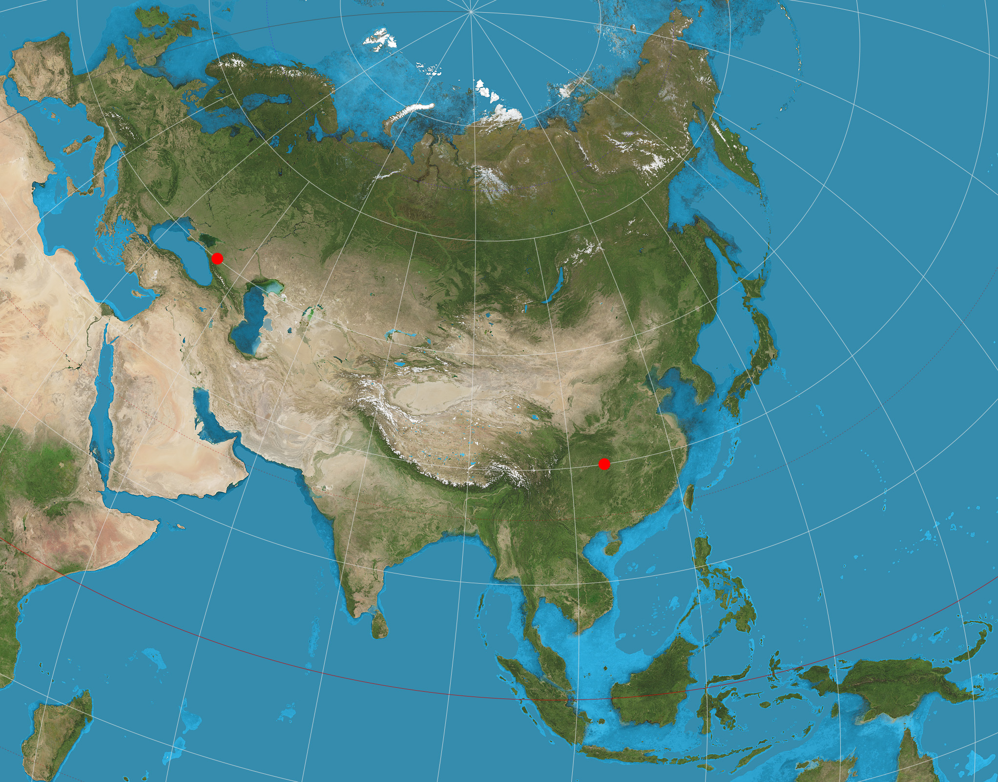
English: Eurasia on two-point equidistant projection. 15° graticule; two anchor points are (45°N, 40°E), (30°N, 110°E). Imagery is a derivative of NASA’s Blue Marble summer month composite with oceans lightened to enhance legibility and contrast. Image created with the Geocart map projection software. |
| Datum | |
| Bron | Eigen werk |
| Auteur | Strebe |
Licentie
Ik, de auteursrechthebbende van dit werk, maak het hierbij onder de volgende licentie beschikbaar:
Dit bestand is gelicenseerd onder de Creative Commons-licentie Naamsvermelding-Gelijk delen 3.0 Unported
- De gebruiker mag:
- Delen – het werk kopiëren, verspreiden en doorgeven
- Remixen – afgeleide werken maken
- Onder de volgende voorwaarden:
- naamsvermelding – U moet op een gepaste manier aan naamsvermelding doen, een link naar de licentie geven, en aangeven of er wijzigingen in het werk zijn aangebracht. U mag dit op elke redelijke manier doen, maar niet zodanig dat de indruk wordt gewekt dat de licentiegever instemt met uw werk of uw gebruik van zijn werk.
- Gelijk delen – Als u het werk heeft geremixt, veranderd, of erop heeft voortgebouwd, moet u het gewijzigde materiaal verspreiden onder dezelfde licentie als het oorspronkelijke werk, of een daarmee compatibele licentie.
Bestandsgeschiedenis
Klik op een datum/tijd om het bestand te zien zoals het destijds was.
| Datum/tijd | Miniatuur | Afmetingen | Gebruiker | Opmerking | |
|---|---|---|---|---|---|
| huidige versie | 21 nov 2021 02:49 | | 2.044 × 1.601 (1,07 MB) | Reseletti | cropped to the actual content, removing a few lines of whitespace borders |
| 19 aug 2011 05:27 |  | 2.058 × 1.616 (1,12 MB) | Strebe | Added anchor point symbols: the two points from which all distances are correct. | |
| 16 aug 2011 00:41 |  | 2.058 × 1.602 (1,1 MB) | Strebe |
Bestandsgebruik
Dit bestand wordt op de volgende pagina gebruikt:
Globaal bestandsgebruik
De volgende andere wiki's gebruiken dit bestand:
- Gebruikt op ar.wikipedia.org
- Gebruikt op de.wikipedia.org
- Gebruikt op en.wikipedia.org
- Map projection
- User talk:Strebe
- Two-point equidistant projection
- Talk:Two-point equidistant projection
- Wikipedia:Featured pictures/Diagrams, drawings, and maps/Maps
- List of map projections
- Wikipedia:Featured pictures thumbs/35
- Wikipedia:Featured picture candidates/June-2013
- Wikipedia:Featured picture candidates/Map Projections Set
- Wikipedia:Picture of the day/August 2014
- Template:POTD/2014-08-30
- Wikipedia:Main Page history/2014 August 30
- Portal:Geography/Selected picture
- Gebruikt op es.wikipedia.org
- Gebruikt op fr.wikipedia.org
- Gebruikt op hu.wikipedia.org
- Gebruikt op id.wikipedia.org
- Gebruikt op it.wikipedia.org
- Gebruikt op ru.wikipedia.org
- Gebruikt op uk.wikipedia.org
- Gebruikt op zh.wikipedia.org