
Bestand:2016 United States presidential election results map by county.svg

Afmetingen van deze voorvertoning van het type PNG van dit SVG-bestand: 555 × 352 pixels Andere resoluties: 320 × 203 pixels | 640 × 406 pixels | 1.024 × 649 pixels | 1.280 × 812 pixels | 2.560 × 1.624 pixels.
Oorspronkelijk bestand (SVG-bestand, nominaal 555 × 352 pixels, bestandsgrootte: 1,74 MB)
| Dit is een bestand van Wikimedia Commons. Onderstaande beschrijving komt van de beschrijving van het bestand daar. |
| Beschrijving |
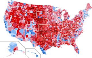
English: Results by county of the United States presidential election, 2016.
Clinton—80-90%
Clinton—70-80%
Clinton—60-70%
Clinton—50-60%
Clinton—40-50%
Clinton—<40%
Trump—<40%
Trump—40-50%
Trump—50-60%
Trump—60-70%
Trump—70-80%
Trump—80-90%
Trump—>90%
|
||||
| Datum | |||||
| Bron |
Dit bestand is afgeleid van: USA Counties.svg |
||||
| Auteur | Ali Zifan en Inqvisitor | ||||
| Toestemming (Hergebruik van dit bestand) |
|
||||
| Andere versies |
[]
|


.svg)
.svg)


Bestandsgeschiedenis
Klik op een datum/tijd om het bestand te zien zoals het destijds was.
| Datum/tijd | Miniatuur | Afmetingen | Gebruiker | Opmerking | |
|---|---|---|---|---|---|
| huidige versie | 4 mrt 2023 01:04 | | 555 × 352 (1,74 MB) | Gordfather69 | line width |
| 1 dec 2019 07:37 |  | 555 × 352 (1,73 MB) | SpeedMcCool | Fixed Tazewell County, Illinois | |
| 21 nov 2019 18:06 |  | 555 × 352 (1,73 MB) | SpeedMcCool | Updated McCone County Montana | |
| 11 okt 2019 03:13 |  | 555 × 352 (1,73 MB) | SpeedMcCool | Fixed Potter and Lehigh Counties PA | |
| 27 okt 2018 23:50 |  | 555 × 352 (1,73 MB) | Vartemp | Fixed shading for McDonald County, MO. | |
| 29 jul 2017 18:16 |  | 555 × 352 (1,73 MB) | Inqvisitor | Two county shading corrections | |
| 15 feb 2017 18:41 |  | 555 × 352 (1,74 MB) | Jayjay8990 | Reverted to version as of 05:49, 8 February 2017 (UTC) | |
| 15 feb 2017 03:50 |  | 990 × 627 (983 kB) | Kingofthedead | Reverted to version as of 05:41, 8 February 2017 (UTC) I disagree that the borders are too thin, and this map is much larger and clearer | |
| 8 feb 2017 07:49 |  | 555 × 352 (1,74 MB) | TL565 | Don't you falsely accuse me of sock puppetry! The map should match the previous county maps and yes the borders are way too thin. | |
| 8 feb 2017 07:41 |  | 990 × 627 (983 kB) | Oganesson007 | @TL565 Please stop reverting the map with the alternative accounts. Also, This map is half of the size of that with optimal border size and more clarification. In this map (unlike the map that you keep putting here) small counties are clearly visible. |
Bestandsgebruik
Dit bestand wordt op de volgende pagina gebruikt:
Globaal bestandsgebruik
De volgende andere wiki's gebruiken dit bestand:
- Gebruikt op ar.wikipedia.org
- Gebruikt op bg.wikipedia.org
- Gebruikt op ca.wikipedia.org
- Gebruikt op cs.wikipedia.org
- Gebruikt op de.wikipedia.org
- Gebruikt op en.wikipedia.org
- Gebruikt op fa.wikipedia.org
- Gebruikt op fr.wikipedia.org
- Gebruikt op hu.wikipedia.org
- Gebruikt op no.wikipedia.org
- Gebruikt op pa.wikipedia.org
- Gebruikt op zh.wikipedia.org