
Bestand:Yom Kippur War map-2.png

Grootte van deze voorvertoning: 399 × 600 pixels. Andere resoluties: 159 × 240 pixels | 401 × 603 pixels.
Oorspronkelijk bestand (401 × 603 pixels, bestandsgrootte: 65 kB, MIME-type: image/png)
| Dit is een bestand van Wikimedia Commons. Onderstaande beschrijving komt van de beschrijving van het bestand daar. |
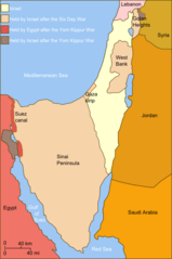
| Beschrijving | Self-made line drawing of a map Israel's ceasefire lines with its neighboring countries after its establishment (1949), after the Six Day War (June 1967) and the last front line after Yom Kippur War (late October 1973). After the latter. Author: User:Raul654 Source of line drawing: Now-deleted image Image:Jom kippur war.jpg, which was originally uploaded to the polish Wikipedia at http://pl.wikipedia.org/wiki/Grafika:Jom_kippur_war.jpg -- Ministerstwo Spraw Zagranicznych Izraela, za zgodÄ… Ambasady Izraela w Polsce. -- Ministry of Foreign Affairs of Israel, with the permission of Israel Embassy in Poland |
| Datum | (UTC) |
| Bron | |
| Auteur |
|
| Dit is een geretoucheerde foto, wat betekent dat de originele versie digitaal aangepast is. Aanpassingen: Israeli territory before the Six day war is the same as after. Het origineel kan hier bekeken worden: Yom Kippur War map.svg. Aanpassingen gedaan door Personal tools * Supreme Deliciousness.
|
Ik, de auteursrechthebbende van dit werk, maak het hierbij onder de volgende licentie beschikbaar:
Dit bestand is gelicenseerd onder de Creative Commons-licentie Naamsvermelding-Gelijk delen 2.5 Unported
- De gebruiker mag:
- Delen – het werk kopiëren, verspreiden en doorgeven
- Remixen – afgeleide werken maken
- Onder de volgende voorwaarden:
- naamsvermelding – U moet op een gepaste manier aan naamsvermelding doen, een link naar de licentie geven, en aangeven of er wijzigingen in het werk zijn aangebracht. U mag dit op elke redelijke manier doen, maar niet zodanig dat de indruk wordt gewekt dat de licentiegever instemt met uw werk of uw gebruik van zijn werk.
- Gelijk delen – Als u het werk heeft geremixt, veranderd, of erop heeft voortgebouwd, moet u het gewijzigde materiaal verspreiden onder dezelfde licentie als het oorspronkelijke werk, of een daarmee compatibele licentie.
Oorspronkelijk uploadlogboek
This image is a derivative work of the following images:
- File:Yom_Kippur_War_map.svg licensed with Cc-by-sa-2.5
- 2010-07-03T14:35:39Z ChrisO 400x602 (44519 Bytes)
- 2010-02-20T12:52:00Z Hohum 400x602 (44263 Bytes) Added border lines.
- 2009-05-31T13:42:58Z Hohum 400x602 (46716 Bytes) Fixed Golan Heights colour.
- 2009-05-31T13:39:18Z Hohum 400x602 (46739 Bytes) Adjusted colours to be less garish, more map-like.
- 2009-04-09T11:32:56Z Kordas 400x602 (46093 Bytes) colours fixed
- 2008-05-15T23:23:08Z Kordas 400x602 (46918 Bytes) Updated version (Added "West Bank" and seas names' in white)
- 2007-10-03T04:11:40Z Andrew Hampe 400x602 (47298 Bytes) Removed line referencing external jpeg image.
- 2007-10-03T03:58:34Z Raul654 400x602 (46347 Bytes) Standard svg
- 2007-10-03T03:55:12Z Raul654 400x602 (46347 Bytes) Self-made line drawing of a map of Israel's territories before and after the Yom Kippur War. Source of line drawing: Now-deleted image [[:Image:Jom kippur war.jpg]] {{cc-by-sa}}
Uploaded with derivativeFX
Bestandsgeschiedenis
Klik op een datum/tijd om het bestand te zien zoals het destijds was.
| Datum/tijd | Miniatuur | Afmetingen | Gebruiker | Opmerking | |
|---|---|---|---|---|---|
| huidige versie | 2 dec 2010 13:03 | | 401 × 603 (65 kB) | Supreme Deliciousness | {{Information |Description=Self-made line drawing of a map of Israel's territories before and after the Yom Kippur War. Author: User:Raul654 Source of line drawing: Now-deleted image Image:Jom kippur war.jpg, which was originally uploaded to the |
Bestandsgebruik
Dit bestand wordt op de volgende 2 pagina's gebruikt:
Globaal bestandsgebruik
De volgende andere wiki's gebruiken dit bestand:
- Gebruikt op ca.wikipedia.org
- Guerra del Yom Kippur
- Resolució 446 del Consell de Seguretat de les Nacions Unides
- Resolució 452 del Consell de Seguretat de les Nacions Unides
- Resolució 471 del Consell de Seguretat de les Nacions Unides
- Resolució 605 del Consell de Seguretat de les Nacions Unides
- Resolució 636 del Consell de Seguretat de les Nacions Unides
- Gebruikt op da.wikipedia.org
- Gebruikt op et.wikipedia.org
- Gebruikt op it.wikipedia.org
- Gebruikt op it.wikibooks.org
- Gebruikt op jv.wikipedia.org
- Gebruikt op pt.wikipedia.org
- Gebruikt op sh.wikipedia.org
- Gebruikt op vi.wikipedia.org
- Gebruikt op www.wikidata.org