
Charwelton
| Civil parish in Engeland | |||
|---|---|---|---|
.svg) | |||
| Situering | |||
| Regio | East Midlands | ||
| Graafschap | Northamptonshire | ||
| District | Daventry | ||
| Coördinaten | 52° 12' NB, 1° 13' WL | ||
| Algemeen | |||
| Oppervlakte | 17,1671 km² | ||
| Inwoners (2011) |
220 (13 inw./km²) | ||
| Overig | |||
| Postcode(s) | NN11 | ||
| Netnummer(s) | 01327 | ||
| Grid code | SP5355 | ||
| Post town | DAVENTRY | ||
| ONS-code | E04006646 | ||
| Foto's | |||

| |||
| Kerkstraat | |||
| |||
Charwelton is een civil parish in het bestuurlijke gebied Daventry, in het Engelse graafschap Northamptonshire met 220 inwoners.
-
 High Street
 -
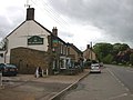 The Fox and Hounds


Geplaatst op:
4-8-2010 |
Dit artikel is een beginnetje over landen & volken. U wordt uitgenodigd om op bewerken te klikken om uw kennis aan dit artikel toe te voegen. |