Saline County (Missouri)
| County in de Verenigde Staten | |||
|---|---|---|---|

| |||
| Situering | |||
| Staat | Missouri | ||
| Coördinaten | 39°8'24"NB, 93°12'0"WL | ||
| Algemeen | |||
| Oppervlakte | 1.980 km² | ||
| - land | 1.957 km² | ||
| - water | 23 km² | ||
| Inwoners (2000) |
23.756 (12 inw./km²) | ||
| Overig | |||
| Zetel | Marshall | ||
| FIPS-code | 29195 | ||
| Opgericht | 1820 | ||
| Foto's | |||
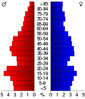
 Bevolkingspiramide Saline County | |||
| Statistieken volkstelling Saline County | |||
| |||
Saline County is een county in de Amerikaanse staat Missouri. Het bestuur van de county zetelt in Marshall. De county werd gesticht in 1820. De naam van de county verwijst naar de zoute bronnen die zich daar bevonden.
De county heeft een landoppervlakte van 1.957 km² en telt 23.756 inwoners (volkstelling 2000). De hoofdplaats is Marshall.
Bevolkingsontwikkeling[bewerken | brontekst bewerken]
| Historische inwonertallen | |||
|---|---|---|---|
| Jaar | Inwoners | % ± | |
| 1900 | 33.703 | ||
| 1910 | 29.448 | −12,6% | |
| 1920 | 28.826 | −2,1% | |
| 1930 | 30.598 | 6,1% | |
| 1940 | 29.416 | −3,9% | |
| 1950 | 26.694 | −9,3% | |
| 1960 | 25.148 | −5,8% | |
| 1970 | 24.633 | −2,0% | |
| 1980 | 24.919 | 1,2% | |
| 1990 | 23.523 | −5,6% | |
| 2000 | 23.756 | 1,0% | |
| Bron: (en) Historical Decennial Census Population | |||
